
8723-10 The Genoa River Valley
|
This information has been developed from the publications:
|
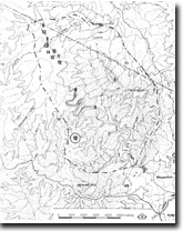
Location: | 087732 (N.S.W./ Victoria Border) to 180600. Genoa River north of Wangarabell | 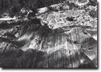 Genoa River. River channel in Ordovician sediments (sandstone, shale and chert). |
Abstract: | Exposures of Devonian Genoa River Beds and associated fossil deposits. Dip slopes, and varying valley and channel morphologies related to lithology. | |
Access: | Yambulla Peak Track off W.B. Line or by walking up the Genoa River from Wangarabell. | |
Ownership: | Crown Land (Coopracambra State Park). | |
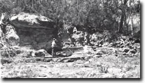
Geology: 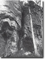 Mount Wakefield. Escarpment of Upper Devonian conglomerates. | Three principal geological units are represented in the Genoa River Valley between the N.S.W. border and Wangarabell. The oldest materials are Ordovician sandstones, slates and siltstones which strike generally north-south and that are steeply dipping, often near vertical (1). These sediments are strongly jointed and crossed with numerous quartz veins, some of which are associated with sulphide mineralisation. Lower Devonian granitic rocks intrude the Ordovician sediments and the contacts are well displayed in the Genoa River north of Wangarabell. The granites are strongly jointed and intruded by dykes. The dykes are predominantly aplitic although doleritic types were observed in the area north of Wangarabell (2). Small pipe cooling features were associated with these doleritic dykes. Of additional interest are the many large xenoliths included in the granite (3). The Ordovician sediments and granitic rocks are in unconformable or faulted contact with the overlying Devonian Genoa River Beds. The Genoa River Beds are composed of sandstone, shale, mudstone and conglomerates, which dip at approximately 7º to the west. Dips are steepened to approximately 15º in the vicinity of the western boundary fault, and the series of possible en echelon faults in the Yambulla Creek, Keyhole Creek and Watervine Creek. The latter site (4) shows that most marked disruption of bedding observed in the area. Minor faulting occurs South of Mount Wakefield where granite, Ordovician and Devonian sediments are in close proximity. Conglomerates predominate at the base of the Devonian sequence and are well exposed in the Genoa near Keyhole Creek and in a scarp, which runs from Mount Wakefield (5), north to Nungatta Mountain. Dip slopes extend from the scarp to the Genoa River and these are strongly dissected by the westward draining tributaries. Higher in the Devonian sedimentary sequence, sandstones and gritty sandstones are interbedded with red-purple mudstones and intraformational conglomerates in the Genoa River gorge sections. The sandstone beds are resisted to erosion and often form prominent cliff ledges and overhangs. The red-purple mudstones or “red beds” form the most conspicuous lithological unit and are well exposed in Key Hole Creek and at sites 8 and 11 in the Genoa River gorge. | |
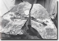
Palaeontology: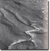 Eroded dip slopes on Devonian sediments between Mount Wakefiled and the Genoa River Gorge. | Of particular interest in the Genoa River gorge are the exposures of fossil bearing strata. Stem casts, and fragments of fern-like leaves (Archaeopteris howitti) occur in dark sandstone near the N.S.W border (6) and just north of Key Hole Creek (7). These fossils show signs of being transported for some distance. Poorly preserved fossil plants occur in several other localities. Small tetrapod footprints have been recorded in fine grained purple-red stone (8). These trackways consists of two columns 8 centimetres apart, the more obscure trail has an additional feature of a sinuous depression between the tracks thought to represent a tail mark. Numerous irregular depressions and small flakes about one centimetre in diameter forming purple-red limonitic areas mark the bedding of the footprint block. Larger depression, including some of the footprints are infilled with micaceous sandstone. The fine grained sandstone of the footprint block is underlain by massive sandstones which form a minor dipslope into the Genoa River. Part of the trackway has been removed and the remainder is obscured by sand accumulation and lichen growth. Fragmented fossils of boney fishes and possibly fish scales were noted at several localities in boulders in the Genoa River (9,10). An in-situ deposit of such material has been located in a lens of sandy conglomerate (11). The lens is overlain by massive, coarsely cross-bedded, medium to fine grained purple-red sandstone. Underlying the lens are green silty shales and purple silty sandstones, which have been differentially eroded leaving the fossil bone deposits, exposed on the underside of an overhang. The bone material of this deposit is thought to be derived from large boney fishes. It is commonly curved, platey and roughly ovoid in shape and the bone structure is well preserved. Other structures, thought to be fish scales also occur in this deposit. Of additional interest is secondary copper enrichment (malachite) occurring along joints and fractures associated with the fossil bone deposit. | |
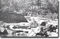
Geomorphology: 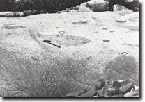 Genoa River, Xenoliths (arrowed), in granite of the Bega Batholith. 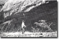 Genoa River Gorge. Sandy conglomerate overhand (arrowed), containing fish fossils (bones, plates and scales). | The most distinctive features of this region are the east-facing scarp extending from Mount Wakefield to Nungatta Mountain, the dissected dip slopes which extended from the scarp to the Genoa River and the gorge and channel of the Genoa River. The Genoa River above Wangarabell is a particularly good example of an eastern Victorian river system, which shows large fluctuations in river discharge. During periods of low discharge the river winds through boulder fields. And sand banks separated by large pools and divides into a braided stream in areas of extensive channel sand deposition. After heavy rain however, the stream transforms into a raging torrent moving large boulders, undercutting channel bank cliffs and scouring the channel sand and transporting it towards Mallacoota Inlet. The form of the river valley and composition of channel sediment are controlled by lithological variations. The Devonian sandstones, siltstones and conglomerates are relatively resistant to erosion and through these materials the Genoa River has cut a gorge which exposes more that 200 metres of the Devonian sedimentary sequence. Cliffs up to 50 metres high occur along the river valley. The stream channel here is generally boulder strewn, sand only occurring on those areas protected from excessive current scour. Of specific interest is an older gravel point bar deposit (12), which overlies a rock terrace, cut in Devonian sediments, and which has been exposed by river erosion. In several places sandstone beds have formed short dip slopes on the river channel edges and these show evidence of scour and exhibit particularly good examples of pothole development (13). Approximately one kilometre south of the Yambulla Peak Track is a series of hight level potholes in an undercut flat lying sandstone bed (14). These potholes are situated between 2 and 2.5 metres above the low discharge level of river, but are within the level reached by flood discharges. They contain pebbles and sand and would consequently still be actively forming during such discharges. Stream undercutting of channel side cliffs is common and wide ledges are formed in those areas of low dip and where more resistant sandstone and conglomerate overly the softer Genoa River Beds. A good example of stream undercutting and overhang formation occurs approximately 200 metres south of the Yambulla Peak Track where an intermittent stream enters the Genoa River (15). Several major waterfalls occur in the Genoa River and these are related to differential erosion of the Devonian sediments (16). At this locality, massive sandstones overly the Red Beds and these dip at approximately 7º to the west. The waterfalls have formed after river downcutting reached the resistant sandstone and erosion of the underlying siltstone continued. The resultant undercutting of the massive sandstones has led to block collapse and waterfall formation. Similar lithologically controlled waterfalls occur in Key Hole Creek where rapid downcutting, probably along a fault line, has exposed a good outcrop of the Genoa River Beds. In addition, this fault has influenced the orientation of the Genoa River producing a large entrenched meander. The granite and Ordovician sediment outcrops in the Genoa River valley are less resistant to erosion than the Devonian sediments and consequently in these areas channel side cliffs are replaced by steep vegetated slopes. The river channel is sandy with areas of boulder bars, where the channel crosses granitic and dyke rocks in the Wangarabell area. Where these rocks outcrop in the river channel good example of scour channels, elongated potholes and other differential erosion features are apparent. | |
Significance: | National and International. This area is of importance for the exposure of the Devonian Genoa River Beds and of particular significance for the fossil discoveries in recent years. The discovery of the tetrapod trackways, the oldest known vertebrate impression in the world, together with the bone deposits which appear to be in the same stratigraphic horizon as the footprints, may offer an opportunity to locate remains of early amphibians. Of geomorphological significance are the dissected dip slopes and gorges in the Devonian sediments together with the changes in valley shape and river channel characteristics associated with changing lithologies. The combination of these features, together with the prominent peaks of Mount Coopracambra and Mount Wakefield produce an area of significant scientific interest and spectacular scenic quality. | |
Management: | The area still retains a wilderness quality and any development should attempt to preserve this impression. Any proposed camping areas, walking tracks and roads should be located in such a way to minimise their visual impact. The fossil deposits are susceptible to degradation by uncontrolled collecting and consequently some form of access restriction is recommended. This could probably be accomplished by closing the Yambulla Peak Track to all vehicles except those for which permits have been issued. The significance of this site is dependent on the maintenance of the Genoa River gorge and quite clearly this would be destroyed by the construction of large reservoirs. Changes in the hydrological and sedimentological regime of the river would result if intensive forest operations were permitted on the steep slopes of the Genoa River catchment, specially between Mt. Merragunegin, Mt. Wakefield and Mealing Hill. A detailed review of the impact of these activities must be undertaken before any developments are approved. | |
References: | Warren, J.W. and Wakefield, N.A. 1972. 'Trackways of Tetrapod vertebrates frp tje Upper Devonian of Victoria, Australia', Nature, 238 :469-470. Douglas, J.G. 1974. 'Explanatory Notes of the Mallacoota 1:250,000 Geological Map', Geological Survey Report, No.1975/5, Mines Department, Victoria. Stainforth, B., Alston, A.J., Bennet, D.J., Camilleri, A. 1976. 'Upper Devonian bones near Genoa', Vict. Nat., 93(2) :56-61. | |
 Cast of fossilised plant stems in Devonian sediments. Genoa River Gorge. | 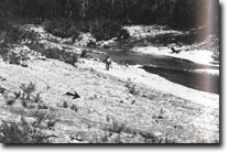 Dip slope, forming river channel, (arrow indicates direction of dip). Genoa River footprints site. |  Entrenched meanders forming the Genoa River Gorge. | |
 Genoa River. Alluvium of gravels and boulders (A), infilling channel excavated in bedrock. | 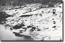 Genoa River Gorge. Pot holes in Devonian sediments. |  Genoa River. Base if high level pothole (arrowed) drilled through sandstone bed. | 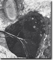 Genoa river. View down high level pothole. |
 Massive sandstone bed, forming nickpoint and waterfall in Genoa River gorge. Figure (arrowed) gives scale. | 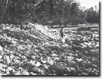 Gravel and boulder bar in Genoa River, downstream from gorge. | 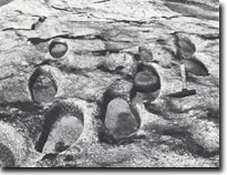 Genoa river. Elongated potholes. |
© State of Victoria (Agriculture Victoria) 1996 - .

This work, Victorian Resources Online, is licensed under a Creative Commons Attribution 4.0 licence. You are free to re-use the work under that licence, on the condition that you credit the State of Victoria (Agriculture Victoria) as author, indicate if changes were made and comply with the other licence terms.
The licence does not apply to ‘branding’ or some ‘images or photographs’ that may be owned by third parties. We ask you to seek prior approval to use images using the VRO feedback form. Access to higher quality images can also be provided on request.
This page was last updated on .