
8722-2 (part on 8822) Wingan Inlet
|
This information has been developed from the publications:
|
Location: | 202200. Approximately 22 kilometres south of the Princess Highway. | 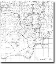 Sites 8722 1, 2, 3 |
Abstract: | Estuary of Wingan River | |
Access: | West Wingan Road from Princess Highway | |
Ownership: | Crown Land (Croajingolong National Park). | |
Geology: | The lower reaches of the Wingan Inlet are incised into granitic racks of the Bega Batholith. The granite outcrops in cliffs and forms rapids and small waterfalls I the river above the inlet (1). Mylonized granite produced along the Elusive Lake Fault is exposed in the upper estuary (2). At Wingan Point on the eastern side of the entrance and at The Skerries (3), a group of rocks 700 metres offshore, are further exposures of the granite which differs from the typical Maramingo Granite in that it contains pink feldspars and may be closely related to the Genoa Peak Granite (8822-12). A feature of the Wingan granitic rocks are the widespread fine grained black sandstone inclusions often closely spaced and up to 10 cms long (4). These are particularly prominent on the eastern side of the entrance channel at Wingan Point. Overlying the granite at Wingan Point is a thin capping of unconsolidated Tertiary sands. | |
Geomorphology: | Wingan Inlet is a compound estuary and consists of two units – a deep, narrow drowned river valley (5) incised into granitic rocks during Pleistocene low sea level times and a broader, generally shallower, barrier enclosed estuarine lagoon (6), with restricted opening to the sea against Wingan Point. The estuary is tidal for a distance of 7 kilometres, the limit of tidal penetration determined by outcrops of granite over which the Wingan River forms a series of rapids and small waterfalls. Above the estuary, the river is confined in an impressive, narrow and possibly fault controlled gorge. The main area of river deposition occurs not at the head of the tidal section, but at a point approximately 3.5 kilometres downstream, where a river delta and river mouth bar are extending into the estuarine lagoon (7). This delta zone and the lagoon shores are fringed by Juncus maritimus marsh (8), or by broad areas of bare inter-tidal mudflat and sandflat (9). An extensive sandy threshold or flood tide delta encumbers the entrance of Wingan Inlet and this is crossed by shifting network of ebb and flood tidal channels (10). The barrier spit that encloses Wingan Inlet extends from the granite headland of Rame Head towards Wingan Point and is capped by vegetated dune ridges. Of particular interest is the development of a low foredune terrace that undergoes progradation for several years but is periodically cut back by storm waves (11). The entrance to the inlet is maintained by tidal and river flow at the eastern side of the barrier spit against Wingan Point in the lee of the Skerries. | |
Significance: | State. Wingan Inlet is classical estuary displaying the characteristics of a small semi-enclosed body of tidal water mixed with substantial river inflow. Its inclusion in the National Park system in Victoria since 1900 has allowed it to remain in a relatively unmodified state and its constitutes a major site for research and teaching on estuarine geomorphology and hydrology. | |
Management: | Power boating should be prohibited so as to reduce both pollution of the inlet and the rate of shoreline erosion. This would greatly enhance the value of the site for studies of water chemistry, turbulence and rates of sediment accumulation. Further increase in the visitor sensitive shoreline features particularly the tidal marshes and mudflats. | |
© State of Victoria (Agriculture Victoria) 1996 - .

This work, Victorian Resources Online, is licensed under a Creative Commons Attribution 4.0 licence. You are free to re-use the work under that licence, on the condition that you credit the State of Victoria (Agriculture Victoria) as author, indicate if changes were made and comply with the other licence terms.
The licence does not apply to ‘branding’ or some ‘images or photographs’ that may be owned by third parties. We ask you to seek prior approval to use images using the VRO feedback form. Access to higher quality images can also be provided on request.
This page was last updated on .