
8622-7 Snowy River Entrance
This information has been developed from the publications:
|
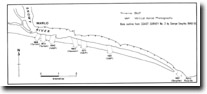
Location: | 340150 to 420145. Outlet of Snowy River – Marlo to Point Ricardo. | 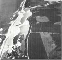 Lagoons and spits at Snowy River entrance, Frenchs Narrows (A). Pre-flood entrance (arrowed). |
Abstract: | Sand barriers, spits, lagoons and tidal entrance to Snowy River. | |
Access: | Boat across Snowy River from Marlo. Footbridge at Frenchs Narrows. Corringle Road to the Splits Backwater. | |
Ownership: | Crown Land. | |
Geology/Geomorphology: | East from Marlo the Snowy River enters and elongated shallow lagoon complex separated from the sea by a low partly vegetated sand barrier. The outlet from this lagoon to Bass Strait is recorded as occupying positions varying from as far as east as Point Ricardo to directly opposite Marlo. On rare instances, this outlet is completely blocked by sand deposition. During floods, the position of the outlet may be rapidly altered – usually a new channel is cut through the barrier near to Marlo and for a time there may be two openings although the former entrance to the east is rapidly closed. The entrance than migrates slowly eastward being deflected by longshore drift but the pattern of spit growth across the entrance indicates movement of material from both east and west. Sand washed through the entrance by flood tides contributes to spit growth in the lagoons and forms an unstable and migrating sandy threshold or submerged tidal delta. The lagoon complex at the Snowy River mouth includes typical estuarine areas with variable salinity due to tidal and river inflow and smaller brackish and fresh water lakes enclosed by spits and transgressive dunes. | |
Significance: | State. The Snowy is the largest river (in terms of discharge) on the Victorian coast and the variable nature of the flow regime maintains a state of continual geomorphological change at the mouth. This provides a major opportunity to study short term changes associated with floods and the longer term patterns of entrance migration and sedimentation. | |
Management: | The value of the site would be seriously reduced if training walls or other engineering structures were built to maintain an artificial entrance into the Snowy River. | |
References: | Rosengren, N. J. 1978. The Physiography of Coastal Dunes, East Gippsland, Victoria. M. A. Thesis (Unpub.), University of Melbourne | |
 Sites 8622 7 to 16 |
© State of Victoria (Agriculture Victoria) 1996 - .

This work, Victorian Resources Online, is licensed under a Creative Commons Attribution 4.0 licence. You are free to re-use the work under that licence, on the condition that you credit the State of Victoria (Agriculture Victoria) as author, indicate if changes were made and comply with the other licence terms.
The licence does not apply to ‘branding’ or some ‘images or photographs’ that may be owned by third parties. We ask you to seek prior approval to use images using the VRO feedback form. Access to higher quality images can also be provided on request.
This page was last updated on .