
8622-2 Dock Inlet
|
This information has been developed from the publications:
|
Location: | 620166. 11 kilometres west of Bemm township. | 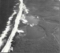 Dock Inlet. River delta (A). Spit (A). |
Abstract: | Freshwater coastal lagoon. | |
Access: | Unformed track from Bemm River or Cape Conran. | |
Ownership: | Crown Land. | |
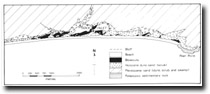
Geology: | Quaternary dune sands and swamp deposits. | |
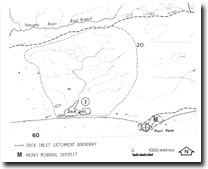
Geomorphology: | Dock Inlet is a freshwater lagoon fed by a small stream system that drains heath and woodland south of the old Coast Road. The lagoon occupies a former embayment which has been enclosed by accumulation of barrier and dune sands and is completely isolated from the sea. The former sea cliff that is now a bluff marking the inner edge of Dock Inlet is cut in consolidated Pleistocene sands which is exposed along the channel of the main inflowing stream. This sinuous channel is in places only two metres wide but is three to four metres deep. Even though the catchment area is small, the holding capacity must be high due to the sandy substrate and the dense cover of swampy heath and stream flow is permanently maintained. The lake water is fresh with salinity below 5 parts per thousand. Shorelines are fringed by Eleocharis sphacelata and Triglochin procera. The lake averages two metres depth but deepens to 3.5 metres on the western side. It is gradually shallowing by encroachment of the fringing swamp vegetation and by addition of dune sands that are blown over the coastal barrier. At low water level the lake is separated into two basins by a sand bar and spit extending from the southern shoreline. The main body of Dock Inlet had no overflow channel to the sea although an area of swamp and low dunes that extend to the west probably mark the site of a former tidal inlet. A small reed and sedge-filled former lagoon one kilometre east of Dock Inlet represents a further stage in the swamp reclamation of a similar fresh water system. | |
Significance: | State. Dock Inlet is a classic example of a fresh water lagoon separated from the sea by only a low sand barrier but rarely subject to wave washover. Of particular interest are the deep river channel that feed the lake, the exposures of older dune materials in the shoreline bluff and the varied shoreline morphology. | |
Management: | Because it is completely enclosed Dock Inlet can be rapidly degraded by over-intensive use – particularly power boating, and this should be prohibited. The catchment area, being small, should be protected in full from logging or land clearing. Development of visitor or camping facilities would be incompatible with maintaining the pollution free lake environment which is necessary to retain the aquatic vegetation. | |
 Sites 8622 1 2 |
© State of Victoria (Agriculture Victoria) 1996 - .

This work, Victorian Resources Online, is licensed under a Creative Commons Attribution 4.0 licence. You are free to re-use the work under that licence, on the condition that you credit the State of Victoria (Agriculture Victoria) as author, indicate if changes were made and comply with the other licence terms.
The licence does not apply to ‘branding’ or some ‘images or photographs’ that may be owned by third parties. We ask you to seek prior approval to use images using the VRO feedback form. Access to higher quality images can also be provided on request.
This page was last updated on .