
8622 (Part 8522)-10 Lake Corringle
|
This information has been developed from the publications:
|
Location: | 320180 to 340190. Three kilometres north-west of Marlo. | 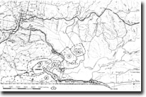 Sites 8622 7 to 16 |
Abstract: | Tidal lagoon. | |
Access: | Boat via Snowy River from Marlo, Corringle Road. | |
Ownership: | Crown Land, partly enclosed by Private Land. | |
Geology/Geomorphology: | Lake Corringle is a shallow lagoon subject to highly variable tidal and river inflow. The lake is connected to the Snowy River by a wide shallow channel encumbered by several vegetated islands and tidal sand and mud flats. It also receives drainage from Ewings Marsh and several small creeks that are incised into the low bluff that borders Lake Corringle to the north. The shorelines are fringed by reed and sedge swamp which is most extensive to the west but has been reduced by clearing and drainage works to the south and east. Lake Corringle is a feature of compound origin – in part it is a large backswamp confined between the low levee of the Snowy River and the bluff to the north but it is also a remnant of a former larger estuarine lagoon of the Snowy and Brodribb Rivers that has been largely isolated by deltaic and flood plain accretion in the Snowy Valley. | |
Significance: | Regional. These are no true tidal delta islands and their mode of origin is not clear. The rainforest on Second island is of special interest. Regional. The morphology and the hydrological and sedimentary processes of Lake Corringle form an integral part of the study of evolution and dynamics of the lower Snowy Valley. The lake also acts as a flood basin during high flow periods in the Snowy River. | |
Management: | No facilities that would encourage greater access to the islands are necessary as this would lead to deterioration of interesting aspects of geomorphology and ecology.The extension of drainage and land reclamation works should be prohibited as this will alter the salinity patterns in Lake Corringle which may have further impact on water circulation and exchange between the lake and the Snowy River. This may result in rapid changes in the ecology of the lower part of the Snowy River estuary. | |
© State of Victoria (Agriculture Victoria) 1996 - .

This work, Victorian Resources Online, is licensed under a Creative Commons Attribution 4.0 licence. You are free to re-use the work under that licence, on the condition that you credit the State of Victoria (Agriculture Victoria) as author, indicate if changes were made and comply with the other licence terms.
The licence does not apply to ‘branding’ or some ‘images or photographs’ that may be owned by third parties. We ask you to seek prior approval to use images using the VRO feedback form. Access to higher quality images can also be provided on request.
This page was last updated on .