
8524-10 Amphitheatre - Mt Cobberas
|
This information has been developed from the publications:
|
Location: | 032200. Eastern slopes of Mount Cobberas No. 1 and Middle Peak. | 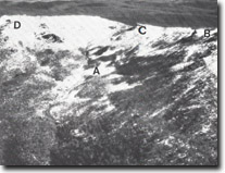 Mount Cobberas. Amphitheatre and vegetated periglacial rock rivers, (A). Cleft peak (B). Middle Peak (C). Mount Cobberas No. 1 (D). |
Abstract: | Large valley-head amphitheatre, rock rivers, stepped valley profile. | |
Access: | Walk from The Playgrounds. | |
Ownership: | Crown Land. | |
Geology/Geomorphology: | The largest of the several valley-head amphitheatres in the Cobberas area lies on the eastern side of the main ridge between Mt Cobberas No 1 and Cleft Peak. This large erosional basin has the general dimensions of a large cirque, and glacial activity has been invoked in some earlier studies to account for its occurrence. There is however, little supporting evidence of Pleistocene glacial activity in the area, as no indisputably glacial relict features such as moraines, faceted boulders or striated surface have been identified. The slopes and floor of the amphitheatre are complex and contain large volumes of loose boulders generally covered by small trees and shrubs, and this fact, together with the degree of weathering of the boulders, indicated they have been inactive for a long period. Three distinct groups of loose boulders are identified on the floor of amphitheatre: a) a relatively small volume of talus from contemporary weathering of cliffs of the Cobberas Range; b) rock rivers, now inactive and consisting of large joint blocks originally derived under preglacial weathering conditions from the strongly jointed outcrops at Middle Peak and Cleft Peak. c) Boulder cascades of smaller rocks arranged as low terrace across the amphitheatre, sometimes with boggy surfaces, and separated by low ramparts of jumbled boulders 2 to 8 metres high. The rock river occupy the steeper side slopes of the amphitheatre (20º to 27º) while the boulder terraces are developed on slopes of 3º to 4º in the lower or central section of the amphitheatre. Similar cirque-like basins occur in the Cobberas at the head of Moscow Creek and Native Dog Creek, and on several of the tributaries of James Creek on the slopes of the Rams Head Range. It appears probable that the amphitheatres and the large boulder accumulations are the result of long periods of weathering- including intensive freeze- thaw action during periglacial climatic regions. | |
Significance: | State. The origin of the amphitheatre is still open to some doubt. However, they represent a major highland relief feature that contributes to the question of the climatic regime that prevailed in South Eastern Australia during Pleistocene times. | |
Management: | Excavations, eg. For road works, which exposed vertical sections in the unconsolidated material would contribute to analysis of the deposits in the amphitheatre. However, the production of artificial rock rubble from such works and disturbance to the steeper slopes may produce local mass movements in the rock rivers that would disrupt their fabric and reduce the validity of analytical studies. Any road widening programs should be preceded by a detailed geomorphological study to determine the exact location of rock rivers. Road alignments should avoid cutting across the largest rock rivers on Mt. Wombargo. | |
References: | Costin, A.B. 1957. 'Further evidence of Pleistocene glaciation in the Victorian Alps', Proc. Linn. Soc. N.S.W., 82 :233-238. Talent,J.A. 1965a 'Geomorphic forms and processes in the Highlands of Eastern Victoria', Proc. R. Soc. Vict., 87(1) :119-134. Talent, J.A. 1969. 'The geology of East Gippsland', Proc. R. Soc. Vict. 82(1) :37-60. | |
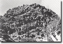 Middle Peak, Mount Cobberas. Jointing in Snowy River Volcanics. Scale given in figure left of white line. | 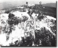 Cleft Peak (A). Moscow Peak (B). Mount Cobberas No. 2 (C). |
© State of Victoria (Agriculture Victoria) 1996 - .

This work, Victorian Resources Online, is licensed under a Creative Commons Attribution 4.0 licence. You are free to re-use the work under that licence, on the condition that you credit the State of Victoria (Agriculture Victoria) as author, indicate if changes were made and comply with the other licence terms.
The licence does not apply to ‘branding’ or some ‘images or photographs’ that may be owned by third parties. We ask you to seek prior approval to use images using the VRO feedback form. Access to higher quality images can also be provided on request.
This page was last updated on .