
8523-9 Gillingall
|
This information has been developed from the publications:
|
Location: | 015680. 11 kilometres north-west of Murrindal. | 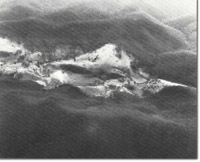 Gillingall. Dolines (arrowed). |
Abstract: | Exposures of Buchan Caves Limestone. Poorly investigated Karst topography. | |
Access: | Gillingall Station Road. | |
Ownership: | Private land. | |
Geology: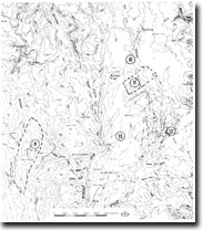 Sites 8523 9 to 13 | Palaeontological studies have revealed that the numerous small outliers of limestone widely distributed over the Snowy River Volcanics can be assigned to a specific stratigraphic section of the main body of carbonate rocks, extending from south of Buchan to Murrindal. The central portion of the Gillingall area consists of an elongate N-S trending outlier of Buchan Caves Limestone, with outcrop dimensions of 7 x 1 km. The limestone is dipping gently to the east, reaching a thickness of approximately 100 m. The outcrop has been extensively cleared and good exposure is afforded both on dipslopes and escarpments. At least 250 m of crystal ingnimbritic rhyodacite forms the basal Snowy River Volcanic unit at Gillingall. Terrestrial dacitic-rhyolitic ignimbrites, pyroclastic and intercalated sediments occur extensively around the margins of the limestone outlier. The volcanics reach a thickness of at least 240 m and have been sub-divided into four main units, into the uppermost formation occurs regularly as a thin margin at the base and margins of the carbonate outlier and is best exposed in a maximum thickness of 15 m and grades upwards into the carbonate sequence. The Bairnsdale 1:250,000 Geology map, shows erroneously, a fault along the western margin of the Snowy River Volcanics, near Gillingall which has been re-interpreted as a non-conformable contact. The Snowy River Volcanics and underlying Upper Silurian sediments and granodiorite have been subjected to epeirogenic block faulting and planation prior to deposition of the Buchan Group. The general sequence observed at Gillingall represents a transition from terrestrial volcanism, through fluviatile volcanic-derived sedimentation to marine carbonate deposition. Much of the volcanics appears of local origin and of restricted extent. The carbonate rocks have been preserved within shallow and apparently conformable or faulted relationships with the volcanics or combinations of the two. The limestones comprise a basal sequence of impure micro-sparrites, which grade up through dolomites and calcarenites to a uniform massive unit of fossiliferous intramicrosparrites. These subunits can be correlated exactly between limestone outliers, suggesting that carbonate sedimentation occurred uniformly over a wide region. The transition from a terrestrial to a marine environment, occurred rapidly after some degree of planation, although some volcanism and associated tectonic activity persisted into times of early carbonate deposition. The structure of the carbonates on a regional scale is simple, with beds generally dipping E at 10 - 20 degrees and shallowly folded about N-S trending fold axes. Relationships between the limestone sub-units at Gillingal are complex. The lower units are locally lentoid, discontinuous or absent, features attributed to small scale faulting during deposition can be observed in Woolshed Creek. Widespread at Gillingall is a thin cherty unit, outcropping as hard, resistant band, which resists weathering and on steep slopes forms a small, pronounced ridge. The fossil assemblage in the limestone at Gillingall is representative of the middle portion of the Buchan Caves Limestone and includes a rich shelly and coral fauna. Large fossil logs similar to the Maramingo Creek deposit have been collected in the Gillingall area, however the extent and precise location of the site are unknown. | |
Geomorphology: | Karst topography is well developed at Gillingall, sinkholes occur near a tributary to Woolshed Creek running east from Dick Hill, and several limestone caves, as yet unexplored, have been reported in the area. The major cave known if Gaping Gilling all (unnumbered), a 40 m deep cave in a unusually elevated position. The area represents a classic Karst barree and is considered to of major speleological significance by the Victorian Speleological Association. Alluvial deposits, and a river terrace occur in Woolshed Creek, north of the Homestead. | |
Significance: | State. The site provides extensive exposures of a major outlier of Buchan Caves Limestone. The Karst features of the area have been poorly investigated and further study may reveal important cave systems. | |
Management: | Access to the area has been severely limited by previous landowners and negotiations with the present owners are necessary to formalize access to the sites. Until a more detailed assessment is made of the significance of the site, it is recommended that only minimum disturbance be permitted on the limestone terrain. | |
References: | Lenard, M. 1976, The Geology of the Gillingal and W Tree Areas, East Gippsland. Honours Thesis (unpub.) Department of Geology, Monash University. Vandeberg, A.H.M., Bolger, P., O'Shea, P.J. (in press) 'Geology and Mineral Exploration of the Limestone Creek-Reedy Creek Area, North-East Victoria', Geol. Surv. Vict. | |
© State of Victoria (Agriculture Victoria) 1996 - .

This work, Victorian Resources Online, is licensed under a Creative Commons Attribution 4.0 licence. You are free to re-use the work under that licence, on the condition that you credit the State of Victoria (Agriculture Victoria) as author, indicate if changes were made and comply with the other licence terms.
The licence does not apply to ‘branding’ or some ‘images or photographs’ that may be owned by third parties. We ask you to seek prior approval to use images using the VRO feedback form. Access to higher quality images can also be provided on request.
This page was last updated on .