
8523-4 Upper Buchan River
|
This information has been developed from the publications:
|
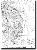
Location: | 030995. Buchan River Valley between Never Never Creek and Lake Creek. | 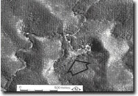 Entrenched meander of Buchan River (arrowed), near Honeysuckle Creek. |
Abstract: | Exposures of Silurian and Ordovician sediments, faulted contacts, fossil sites and complex entrenched meander. | |
Access: | Sugar Loaf Track. | |
Ownership: | Crown land. | |
Geology: | Ordovician and Silurian sediments outcrop in the valley of the Buchan River. These sediments have been faulted and intruded by acid and granitic dykes (1). The fault boundaries are marked either by zones of mineralization boudinage structures or sheared sediments. The Ordovician sediments consist of spotted phyllites, quartzites and occasionally black slates. Exposures of black slates on Reedy Track have yielded poorly preserved Upper Ordovician graptolites (2). The Ordovician sediments are separated from the Silurian sediments (Tawonga Sandstone) by the Reedy Creek Fault, the location of which is indicated by sheared meta sediments in the Buchan River near its junction with Lake Creek (3). A limestone lens with the Tawonga Sandstone is exposed along the Reedy Creek Fault between the Buchan River and Cave Creek (4). This limestone is known as the Lobelia Member and contains the fossils Phaulactis, Heliolites, Favosites and Hindeodella equi dentata, the latter fossil suggesting an age for this member similar to that of the Cowombat Siltstone. Further to the south, near the junction of Reedy Creek and the Buchan River, Ordovician sediments are faulted against the Silurian Gibsons Folly Formation. This formation consists of interbedded acid volcanics, siltstone, slate and minor tuff. The fualt is indicated by boudinage sandstone in Reedy Creek (5). Further downstream in the Buchan River, near Limestone Creek, the Gibsons Folly Formation is faulted against Tawonga Sandstone, and this fault is marked by a band of massive, fine grained pyrite, which contains a few remnants of limestone and quartz reef (6). In addition two limestone lenses (an un-named member (7) and the Caladenia Limestone Member (8)) of the Tawonga Sandstone outcrop in this area. These contain macro-fossils. | |
Geomorphology: | Of particular significance geomorphologically is the complex entrenched occurring on the Buchan River near to the junction with the Honeysuckle Creek (9). The straight eastern side of the meander indicates some form of geological structural control. | |
Significance: | State. This area contains several stratigraphically important elements of the Silurian sedimentary sequence together with good exposures of the faulted contacts between the Ordovician sediments, Tawonga Sandstone and Gibsons Folly Formation. | |
Management: | The value of this site depends on the maintenance of the geological exposures. Land use which is inconsistent with this general principle (ie those that would remove major features or obscure them from view by flooding) should not be approved. | |
© State of Victoria (Agriculture Victoria) 1996 - .

This work, Victorian Resources Online, is licensed under a Creative Commons Attribution 4.0 licence. You are free to re-use the work under that licence, on the condition that you credit the State of Victoria (Agriculture Victoria) as author, indicate if changes were made and comply with the other licence terms.
The licence does not apply to ‘branding’ or some ‘images or photographs’ that may be owned by third parties. We ask you to seek prior approval to use images using the VRO feedback form. Access to higher quality images can also be provided on request.
This page was last updated on .