
8523 (8522)-24 The Thrust Fault Area
Sites 8523 (8522) 16 to 30 - The Buchan/Murrindal Limestone Basin
This information has been developed from the publications:
|
Location: | 075480. Tara Creek, Buchan River to Wilson Cave Reserve. | 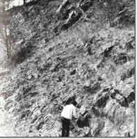 East Buchan. Spring Creek Member of Buchan Caves Limestone. |
Abstract: | Exposures of East Buchan Thrust fault, the Spring Creek Member and several important caves and other karst features. | |
Access: | Buchan - Orbost Road. | |
Ownership: | Private land with small Crown land reserve. | |
Geology: | The area is of particular importance for its exposures of the lithology which separates the Snowy River Volcanics from the limestones of the Buchan Caves Limestone (Spring Creek Member). The East Buchan thrust fault is also clearly displayed. On the Buchan - Orbost Road, just north of the bridge over the Buchan River, the road cutting exposes ash beds, tuffs and coarse sandstones interbedded with three distinct bands of limestone. These sediments and volcanics have been thrust over middle Buchan Caves massive limestone. Fault movement has resulted in crushing of the massive limestone while the softer overlying sediments are folded and also crushed. The best exposure of the thrust fault occurs on the south side of the Buchan River approximately 0.5 kilometres upstream from the Buchan - Orbost Road bridge. At this locality blocks of the lower part of the Buchan Cave Limestone have been thrust over middle to upper limestone of the same formation. The younger bedded limestone are intensely folded and other minor features such as slickensides are associated with the thrust zone. Several caves also occur in the thrust zone (e.g Cloggs Cave EB-2). The thrust fault is comparatively small, having a throw of approximately 85 m and a total displacement of less than 150 m. To the south of the fault a belt approximately 1 kilometre wide is closely folded, the fold axes being parallel to the thrust fault. These fold are well exposed on the hilltop to the south of the thrust fault cliff. Of additional geological interest in this area is the deposit of biohermal limestone in the vicinity of Wilsons Cave (EB-4). Such biohermal deposits are uncommon in the Buchan Caves Limestone and are here composed of the coral Favosites bryani and stromatoporoids. | |
Geomorphology: | 8 major caves are associated with the thrust fault zone, the most important being Cloggs Cave. The cave is formed in an anticline and is of particular significance as it contains a stratified and undisturbed human occupation deposit which includes bone and stone tools and a rich faunal assemblage. Studies have established occupation to 17,720 840 BP and have yielded important contributions in palae-environments and palaeo-climatology. Wilsons Cave system (EB-4) though suffering from vandalism is still recognized as an important cave. These caves being in a blind valley and consists of a series of lofty chambers which extend for approximately 200 m. Wilsons Cave is one of the few through-caves known in the Buchan area. In addition, the surrounding hillslopes show good examples of collapsed sinkholes, solution dolines and rillenkarren. The relict course of Tara Creek is of importance geomorphologically. The Buchan River by erosion of a meander edge captured the lower part of the Tara Creek and diverted it, leaving an abandoned valley. This is the best example of stream capture and consequent stream diversion in the Buchan region. | |
Significance: | State. Best exposure of a thrust fault in Victoria together with representative and accessible examples of the Spring Creek Member. Several caves in the area are of significance while the process of stream capture and diversion is well displayed in Tara Creek. | |
Management: | The range and quality of features occurring in this area make it a valuable resource and any actions which may alter the accessibility or the quality of the display of the features should be avoided. Specifically actions which would lead to the removal or obscuring of the thrust fault or Spring Creek Member exposures would seriously reduce the value of this site. Deterioration of the Wilsons Cave system has occurred due to overuse and many features have been vandalised. This highlights the need for a detailed cave resource assessment so that a comprehensive management prescription can be formulated for the Buchan area as a whole. Action such as that taken at Cloggs Cave, whereby access is controlled by the Victorian Speleological Association, by means of a locked gate, may be necessary at other localities. Until such studies are completed, it is recommended that the general management considerations outlined be applied to this area. | |
References: | Kitson, A.E. 1907. 'Proposed reservation of limestone caves in the Buchan District, Eastern Gippland', Rec. geol. Surv. Vict., II(I) :37-44. Tiechert, C. and Talent, J.A. 1958. 'Geology of the Buchan area, East Gippsland', Mem. geol. Surv. Vict., 21: 1-56. Matthews, P.G. (ed) 1968. Speleological Handbook. Victorian Speleological Association. Flood, 1973. White, N.J. and Davey, A. 1977. 'Pollution of Moons Cave, Buchan, Victoria : A Case Study in Cave Reserve Management', Proc. 11th Biennial Conference, Australian Speleological Federation. Canberra, 1976. | |
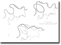
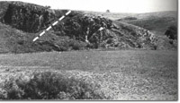 East Buchan Thrust, (dotted line indicates fault plane). | 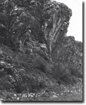 East buchan Thrust Fault. Detail of folding. | 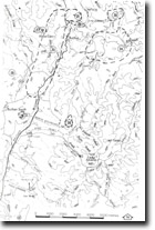 8523 (8522)-20 to 8523-21, 23-24, 26-31 |
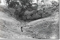 Blind Valleu leading to Wilson Cave (EB-4). | 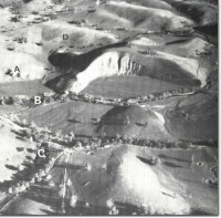 East Buchan Thrust Fault area. Thrust Fault (A), Buchan River (B). Blind valley (C). Folds (D). Old course of Tara Creek (dotted). |
© State of Victoria (Agriculture Victoria) 1996 - .

This work, Victorian Resources Online, is licensed under a Creative Commons Attribution 4.0 licence. You are free to re-use the work under that licence, on the condition that you credit the State of Victoria (Agriculture Victoria) as author, indicate if changes were made and comply with the other licence terms.
The licence does not apply to ‘branding’ or some ‘images or photographs’ that may be owned by third parties. We ask you to seek prior approval to use images using the VRO feedback form. Access to higher quality images can also be provided on request.
This page was last updated on .