
8523-17 Scrubby Creek Area
Sites 8523 (8522) 16 to 30 - The Buchan/Murrindal Limestone Basin
This information has been developed from the publications:
|
Location: | 044556. Scrubby Creek to Dicksons Caves (M-30). | 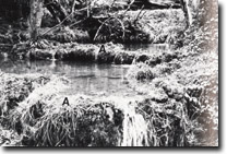 Tufa terraces (A) on Scrubby Creek cave system (M-49). |
Abstract: | Sediments and karst landforms. | |
Access: | Old Buchan - Murrindal Road. | |
Ownership: | Predominantly private land - small public land reserve around Dicksons Caves. | |
Geology: | Thickly bedded and massive biohermal limestones of the Rocky Camp Member outcrop on the eastern slopes of Scrubby Creek. These limestones comprise a strongly coralline facies of the Murrindal Limestone which is in this area downthrown against Buchan Caves Limestone. Exposures are generally poor except near the southern end of the area and where recent landslides have exposed the underlying rock. | |
Geomorphology: | This area exhibit’s a range of surface karst features. These include blind valleys, pot holes, tufa terraces and most importantly a permanent outflow cave. This cave is presumed to be hydrologically connected to a large number of other caves in the area. The major caves are, Scrubby Creek (M-49), Storm Water Tunnel (M-43), SSS Cave (M-44), Dicksons Caves (M-30) and The Canyons (M-18). Scrubby Creek Cave (M-49) is a long stream passage type cave with small offshoots which are well decorated. Calcite rafts and speleothems are notable features. The main passage way, greater than 1 kilometre in length, is blocked by permanent water filled sumps and is drained by a major outflow stream. This stream is highly charged with carbonates and deposition of this material around pool edges outside the cave has resulted in an impressive series of tufa terraces. These features are being damaged at the present time by cattle trampling. Scrubby Creek Cave (M-49) is probably fed by the intermittent inflow cave, Storm Water Tunnel (M-43). This stream passage cave originates in a blind valley and receives significant amounts of surface runoff during wet periods. Additionally, it is thought that The Canyons (M-18) and Caves M-19, M-20 and M-21 all intermittently feed Scrubby Creek Cave. The most important of these, The Canyons, is characterized by an extensive ramifying joint-plan system which leads down to a stream passage. A large number of dolines occur in the Dicksons Caves area and together with the adjacent Potholes Area provide the best example of this type of karst topography in Victoria. The larges of Dicksons Caves consist of small pitches which connect three separate cave levels. Some of the chambers are quite imposing although only sparsely decorated with massive stalactital forms. The quality of these caves has been degraded by vandalism and the dumping of rubbish. The final cave of particular importance is the SSS Cave (M-44). A narrow 18 m entrance in a pothole, isolated from the main pothole area. A narrow 18 m entrance shaft leads to a series of well decorated chambers and a fissure with a large quantity of old bat guano. There is no record of recent bat habitation. This cave is particularly notable for its false floors and flowstone canopy. | |
Significance: | National. The area provides excellent examples of a permanent outflow cave, tufa terraces, potholes, blind valleys, ramifying joint planes and stream channel caves and cave decoration. | |
Management: | Insufficient information on cave hydrology is available to formulate a detailed management prescription for this cave area. However, deterioration of some caves through vandalism and the dumping of rubbish has already occurred. Scrubby Creek Cave is presently gated and access is controlled by the Victorian Speleological Association. This cave is particularly dangerous and easily degraded by overuse, and the VSA policy of limiting access to well qualified personnel is endorsed. In general, the management consideration outlined apply to this discussion and any proposed land use changes must be preceded by a thorough study of environmental effects. The tufa terraces are presently being destroyed by cattle trampling. The fragility and significance of this feature warrant protective fencing. | |
References: | Stirling, J. 1887. 'The physiography of the Tambo Valley', Ibid, 1(2) :37-66. Kitson, A.E. 1907. 'Proposed reservation of limestone caves in the Buchan District, Eastern Gippland', Rec. geol. Surv. Vict., II(I) :37-44. Tiechert, C. and Talent, J.A. 1958. 'Geology of the Buchan area, East Gippsland', Mem. geol. Surv. Vict., 21: 1-56. Sweeting, M.M. 1960. 'The caves of the Buchan area, Victoria, Australia', Z. Geomorph. Suppl., 2 :81-89. Talent, J.A. 1958. 'Devonian Brachiopods and Pelecypods of the Buchan Caves Limestone, Victoria'. Proc. R. Soc. Vict., 68-70 :1-61. Matthews, P.G. (ed) 1968. Speleological Handbook. Victorian Speleological Association. Matthews, P.G. (ed) 1979. Checklist of Australian Caves and Karst. Australian Speleological federation. Nicoll R.S. and Brush, J.B. 1976. Guidebook to the caves of South Eastern N.S.W. and Eastern Victoria. A.S.F. Guidebook No.1. White, N.J. and Davey, A. 1977. 'Pollution of Moons Cave, Buchan, Victoria : A Case Study in Cave Reserve Management', Proc. 11th Biennial Conference, Australian Speleological Federation. Canberra, 1976. Victorian Speleological Association 1979. 'The Potholes Area, Murrindal, Victoria. V.S.A., Melbourne. | |
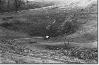 Blind valley leading to Stormwater Tunnel Cave (M-43). |
© State of Victoria (Agriculture Victoria) 1996 - .

This work, Victorian Resources Online, is licensed under a Creative Commons Attribution 4.0 licence. You are free to re-use the work under that licence, on the condition that you credit the State of Victoria (Agriculture Victoria) as author, indicate if changes were made and comply with the other licence terms.
The licence does not apply to ‘branding’ or some ‘images or photographs’ that may be owned by third parties. We ask you to seek prior approval to use images using the VRO feedback form. Access to higher quality images can also be provided on request.
This page was last updated on .