
8523-1 Reedy Creek Chasm
|
This information has been developed from the publications:
|
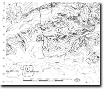
Location: | 973003. 9 kilometres north-east of Mt Nunniong. | 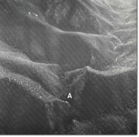 Reedy Creek Chasm (A). |
Abstract: | The area displays exposures of the contact between Upper Devonian Forlorn Hope Granodiorite and Silurian Tawonga Sandstone, a faulted contact between the latter and Ordovician sediments, an eroded fault controlled scarp, and fault controlled stream channel and river gorge. | |
Access: | Reedy Track and Brumby Point Track. | |
Ownership: | Crown land. | |
Geology: | Medium to coarse-grained grey Forlorn Hope Granodiorite has intruded Silurian Tawonga Sandstone producing hornfels in the contact zone. The Tawonga Sandstone consists of fine-grained sandstones, quartzites and mudstones which are in this area interbedded with thin flows of acid volcanics. The Tawonga Sandstone in the area of Reedy Creek Gorge is faulted against Ordovician quartzites, phyllite and slate. These sediments are well exposed on the souther slopes of the gorge. The fault line is indicated by sheared quartzites in the Channel of Reedy Creek. Along this fault line, The Farquhar Limestone Member of the Tawonga Sandstone is exposed in Farquhar Creek. This limestone contains Propora, Heliolites and the conodonts, Czarkodina and Hindeodella, the latter suggesting an age close to that of the Cowombat Siltstone, and may indicate contemporaneous deposition of the lower parts of the Tawonga Sandstone and the Cowombat Siltstone. | |
Geomorpholgy: | The Forlorn Hope Granodiorite forms a plateau to the north of the Reedy Creek Fault and the low gradients and consequent irregular drainage has produced high altitude swamps in this area. Streams draining the plateau plunge over an escarpment which falls more than 200 m in less than 1 km. As a consequence falls, rapids and minor gorges occur on these streams. Reedy Creek has excavated a major gorge largely in sheared Ordovician sediments, associated with the Reedy Creek Fault. Cliffs over 100 m high have formed and are prominent in the area known as the Reedy Creek Chasm. Evidence of Pleistocene periglacial weathering occurs in the form of minor rock rivers and scree slopes. Of major significance is a very distinctive vegetation pattern which displays a series of parallel stripes on the slopes on the southern side of the Reedy Creek Chasm, and across ride crests traversed by the Brumby Point Track, similar slopes occur on Digger Hole Spur, to the south of Little Reedy Creek. The origins of this pattern, and its relationship to lithology, structure and weathering processes is unknown and appears to be unique in Victoria. Compare also site (8223-5 The Big Plain). | |
Significance: | State. Rating of at least State significance level is warranted for the array of geological and geomorphological features. The area may be of national significance if the striped vegetation pattern is related to a unique periglacial weathering process. | |
Management: | The quality of the site is dependent upon preservation of the outcrops, fossil sites and geological structures and particularly on the maintenance of the geomorphological context (i.e. the Chasmand related deep valleys) in which these are displayed. The distinctive striped vegetation pattern should not be disturbed in any way until the phenomena is thoroughly investigated. | |
References: | Vandenberg, A.H.M. and O’Shea, P.J. 1980. 'Explanatory Notes on the Bairnsdale 1:250,00 geological map', Rep. geol. Surv. Vict., No.65. | |
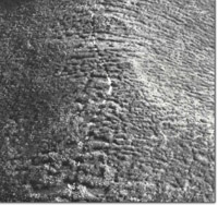 Reedy Creek Chasm. Vegetation stripes across ridge crests |
© State of Victoria (Agriculture Victoria) 1996 - .

This work, Victorian Resources Online, is licensed under a Creative Commons Attribution 4.0 licence. You are free to re-use the work under that licence, on the condition that you credit the State of Victoria (Agriculture Victoria) as author, indicate if changes were made and comply with the other licence terms.
The licence does not apply to ‘branding’ or some ‘images or photographs’ that may be owned by third parties. We ask you to seek prior approval to use images using the VRO feedback form. Access to higher quality images can also be provided on request.
This page was last updated on .