
8522-5 Lake Tyers
|
This information has been developed from the publications:
|
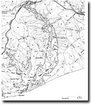
Location: | 960100. Lake Tyers. | 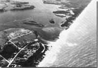 Tidal delta - Lake Tyers. |
Abstract: | Drowned river valley estuary, tidal delta, outcrops of Tertiary limestone. | |
Ownership: | Crown land, some private land. | |
Geology: | Tertiary calcareous sediments crop out along the shoreline of Lake Tyers, particularly the upper reaches of the Nowa Nowa Arm where they occur in cliffs to 30 metres high. The sections have not been described in detail but are of Middle to Late Miocene age and probably include beds of Gippsland Limestone, Bairnsdale Limestone Member and Tambo River Formation. | |
Geomorpholgy: | Lake Tyers was formed by submergence of the valleys of Boggy Creek and Stony Creek by the Holocene marine transgression. It is similar in many respects to Mallacoota Inlet though the barrier-enclosed lower lake basin is smaller. The Nowa Nowa Arm reaches almost to the Princes Highway and is a deep, narrow and branching inlet. Many tributary valleys and spurs have been submerged along this and the Toorloo Arm giving rise to long reaches of sheltered waterway. The walls of the Inlet rise steeply 20 to 40 metres giving a gorge-like appearance along parts of the Nowa Nowa Arm and the floor generally plunges steeply to four to seven metres depth. The lake floor is generally flat rather than “V” shaped giving the impression of a submerged flood plain. Two deep holes (Devils Hole) up to 20 metres deep in the upper section of the Nowa Nowa Arm, are due possibly to the collapse of caves or solution pipies in the limestone. Several of the drowned spurs terminate as small sandy and shelly spits which extend across the mouths of the small adjacent embayments. The outlet to the sea is typically closed by a barrier beach. | |
Significance: | Regional. This is the second largest ria (submerged branching valley) on the Gippsland coast. | |
Management: | Frequent artificial opening of the entrance will lower the water level and increase the salinity of the lake causing die back of fringing reed swamp and initiating shoreline erosion. It is recommended that the natural cycle of entrance opening and closure be allowed to continue. | |
© State of Victoria (Agriculture Victoria) 1996 - .

This work, Victorian Resources Online, is licensed under a Creative Commons Attribution 4.0 licence. You are free to re-use the work under that licence, on the condition that you credit the State of Victoria (Agriculture Victoria) as author, indicate if changes were made and comply with the other licence terms.
The licence does not apply to ‘branding’ or some ‘images or photographs’ that may be owned by third parties. We ask you to seek prior approval to use images using the VRO feedback form. Access to higher quality images can also be provided on request.
This page was last updated on .