
8522-4 Ewing Marsh at Simpson Creek
8522-3, 4 Ewings Marsh (Barrier and Lagoon)
This information has been developed from the publications:
|
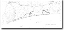
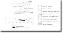
Introduction: | A dune capped sand barrier formation extends for over 50 kilometres between Red Bluff near Lake Tyers and Point Ricardo east of Marlo, enclosing a complex of swamps and lagoons and blocking or diverting the mouth of several streams including the Snowy River. Behind the lagoon is a clearly defined bluff, a former sea cliff which marks the edge of a coastal terrace eroded in Tertiary marls, limestones and sandstones. In broad detail the barrier-lagoon-bluff system is analogous with that of the Ninety Mile Beach and lakes of the Gippsland Lakes region. | |
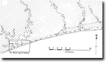
The dune-capped barrier averages 80 to 100 metres wide and is fronted by a narrow and steeply sloping beach. Near Red Bluff the barrier lies at the base of the marginal bluff and extends as a beach across the mouth of Lake Tyers. East of Lake Tyers, the barrier initially lies against the bluff, it stands 200 to 300 metres seaward of the bluff and encloses Ewing Marsh, a swamp-filled former lagoon. None of the streams entering Ewing Marsh are of sufficient discharge to maintain an opening across the vegetated barrier and apart from Hospital Creek, all have swamp-filled and alleviated valleys with only small areas of open channel. The barrier for the most part is a single high scrub-covered dune ridge with a low grassy foredune. Near Lake Tyers is a short section where there are from two to four low parallel rear-dune ridges. The high ridge has been extensively modified by the formation of blow-outs and short parabolic dunes, many of which extend across the barrier and deliver sand into Ewing Marsh. The blow-outs are longer and the ridges become higher as the trend of the coastline becomes more east-west near Marlo. On the inner edge of Ewing Marsh are remnants of low ridges of deeply leached sand which suggest the existence of at least one Pleistocene sand barrier emplaced against the base of the marginal bluff. | ||
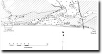
Location: | 210160. 6 kilometres south of Princes Highway between Lake Tyers and Marlo. | 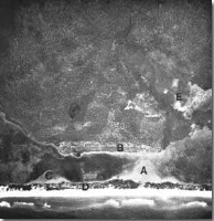 Ewing Marsh near Simpson Creek. Washover fan (A). Older barrier (B). Relict lake-shore spit (C). Outer barrier (D). Infilled former estuary of Simpson Creek (E). (Source RAAF 1940). |
Abstract: | Older barrier sands, relict washover fan, peat and swamp deposits. | |
Access: | Beach Road from Princes Highway. | |
Ownership: | Crown land. | |
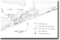
Geology: | The 20 metre coastal terrace cut in Tertiary sediments ends in a low coastal bluff on the northern side of Ewing Marsh. In places the bluff is distinct with an abrupt break of slope forming the inner margin of the marsh but in several places there are low, broad sandy ridges that lie against the base of the bluff. The sands are deeply leeched ad include a well cemented humate horizon which indicates they are remnants of a Pleistocene beach and barrier system formed adjacent to the marginal bluff. The barriers have been dissected by the outflowing streams during glacial low sea level phases. Several cuspate and lobate sand bodies extend into Ewing Marsh from the outer barrier and overlap onto the peats and organic muds that fill the former Ewing Marsh lagoon. These mark the position of washovers across the barrier before it was built to its present heights. The elongate shape of some of these suggest they have been reworked as lagoon shore spits. | |
Significance: | Regional. The features described are of major importance in displaying aspects of the late Quaternary evolution of the Ewing Marsh lagoon and barrier system. They can be usefully compared with similar physiographic features in the Gippsland Lakes. | |
Management: | Land use that removed or obscured the older barrier sands would need to be evaluated in terms of its specific impact on the site. It is important that substantial sections of the barrier sands remain undisturbed. | |
References: | Rosengren, N.J. 1978. The Physiography of Coastal Dunes, East Gippsland, Victoria. M.A. Thesis (unpub.), University of Melbourne. | |
© State of Victoria (Agriculture Victoria) 1996 - .

This work, Victorian Resources Online, is licensed under a Creative Commons Attribution 4.0 licence. You are free to re-use the work under that licence, on the condition that you credit the State of Victoria (Agriculture Victoria) as author, indicate if changes were made and comply with the other licence terms.
The licence does not apply to ‘branding’ or some ‘images or photographs’ that may be owned by third parties. We ask you to seek prior approval to use images using the VRO feedback form. Access to higher quality images can also be provided on request.
This page was last updated on .