
8522-1 Snowy River - Wood Point to Jarrahmond
|
This information has been developed from the publications:
|
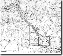
Location: | 165330 to 240255. Snowy River Valley 5 to 12 kilometres north-west of Orbost (Jarrahmond, Bete Bolong and Wood Point). | 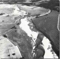 Snowy River floodplain, with large flood crevasse (A), at Bete Bolong. |
Abstract: | Contrasting valley forms of Snowy River. | |
Access: | Orbost - Buchan Road, Black Break Track. | |
Ownership: | Crown land at Wood Point, private land on the Jarrahmond and Bete Bolong flats. | |
Geology: | Steeply dipping Ordovician sandstones and slates outcrop along the narrow Snowy Valley from Wood Point to Bete Bolong. South of Bete Bolong the valley is flanked by Tertiary sediments (sandstones and limestones) and flood plain sands, silts and gravels. | |
Geomorpholgy: | For much of its length in Victoria, the Snowy River is confined in an impressive gorge in Palaeozoic sedimentary and volcanic rocks and there is limited flood plain development. The valley from Wood Point to Bete Bolong is steep and narrow with Wood Point being an elongated, probably structurally controlled meander spur. At Stony Creek, the Ordovician rocks pass below Tertiary sandstones and limestones and in these softer rocks the valley widens abruptly and the Snowy River has developed a well defined flood plain subject to rapid and large scale flooding. The valley fill processes are a combination of alluvial fan formation and flood plain aggradation. These are well demonstrated by the large flood crevasse and sand splay that occurs at Jarrahmond and the broad black swamp and abandoned channel south-west of Bete Bolong. | |
Significance: | Regional. The area displays clearly the major geomorphologic processes related to stream erosion and deposition at mountain front. | |
Management: | Recurrent flooding leading to rapid bank erosion and overbank deposition is inherent at this location. Detailed evaluation of property damage against the dynamic interest of the site needs to be undertaken before further engineering works for flood protection are implemented. | |
© State of Victoria (Agriculture Victoria) 1996 - .

This work, Victorian Resources Online, is licensed under a Creative Commons Attribution 4.0 licence. You are free to re-use the work under that licence, on the condition that you credit the State of Victoria (Agriculture Victoria) as author, indicate if changes were made and comply with the other licence terms.
The licence does not apply to ‘branding’ or some ‘images or photographs’ that may be owned by third parties. We ask you to seek prior approval to use images using the VRO feedback form. Access to higher quality images can also be provided on request.
This page was last updated on .