
8424-6 Morass Creek
|
This information has been developed from the publications:
|
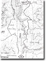
Location: | 625245. Morass Creek between the junctions of Deep Creek and Stony Creek, 13 kilometres north of Benambra. | 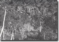 Morass Creek Gorge. Cliff of multiple flows of basalt, (newer Volcanics). Lower flow displays strong columnar jointing contributing to talus slope. Dotted line indicates contact between two flows. |
Abstract: | Exposures of Newer Volcanics, Triassic quartz porphyry and Wombat Creek Group sediments. Short river gorge, drainage modification by basalt flows. | |
Access: | Benambra- Corryong Road | |
Ownership: | Crown Land with a small enclave of Private Land at the junction of Deep Creek and Morass Creek. | |
Geology/Geomorphology: | Newer Basalts are restricted in extent in Eastern Victoria, occurring only near Frasers Tableland. These flows have occupied the valleys of Moras Creek and the Mitta Mitta River and attain a maximum thickness of between 130 and 140 metres in Moras Creek. Approximately 250 metres downstream from the junction of Deep Creek, the Moras Creek has cut a gorge in the basalt with cliffs reaching 100 metres in height. These expose a number of flows, some of which display prominent columnar jointing and large screes of basalt boulders have developed at the cliff base. The damming of Moras Creek behind these flows has given rise to the extensive alluvial deposits north and east of Benambra. The basalt overlies Triassic quartz-porphyry, which is poorly exposed in Morass Creek. However, highly weathered sections are displayed in road cuttings on the Benambra-Corryong road. The Silurian Wombat Creek Group sediments are down faulted against Ordovician sediments in Morass Creek. The exposures are mainly obscured by a dense growth of blackberries, however, the position of the fault is indicated by large boulders of breccia. | |
Significance: | State. The youngest basalt flows known in Eastern Victoria are well displayed in the Morass Creek gorge. | |
Management: | Because of the size of the area covered by the site, the value of the significant geological/ geomorphological features is unlikely to be seriously reduced by localised land disturbance. However, large scale construction works and/or flooding of the gorge section through the construction of reservoirs would significantly degrade the site. | |
References: | Crohn, P.W. 1950. 'The geology, petrology and physiography of the Omeo District, North-Eastern Victoria', Proc. R. Soc. Vict., 62 :1-70. | |
Site 8424-6
© State of Victoria (Agriculture Victoria) 1996 - .

This work, Victorian Resources Online, is licensed under a Creative Commons Attribution 4.0 licence. You are free to re-use the work under that licence, on the condition that you credit the State of Victoria (Agriculture Victoria) as author, indicate if changes were made and comply with the other licence terms.
The licence does not apply to ‘branding’ or some ‘images or photographs’ that may be owned by third parties. We ask you to seek prior approval to use images using the VRO feedback form. Access to higher quality images can also be provided on request.
This page was last updated on .