
8424-3 Buenba Creek
|
This information has been developed from the publications:
|
Location: | 785375. 14 kilometres north-east of Pendergast Lookout. | 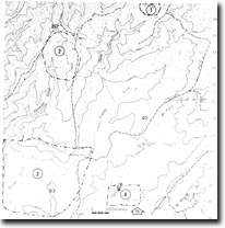 Sites 8424 1-4 |
Abstract: | River gorge, entrenched meander, pocket alluvium and a major fault lineament. | |
Access: | Tom Groggin Track. | |
Ownership: | Crown Land | |
Geology/Geomorphology: | Movements on the Buenba Fault have markedly affected the landforms in the area. A scarp cut in Ordovician sediments forms a prominent lineament trending north-east, while to the west of the scarp, Buenba Creek has cut a gorge distinctive for its entrenched meanders. Drainage disruption by the fault has resulted in the formation of pockets of alluvium, separated by area of greater stream gradient and steeper valley side slopes. | |
Significance: | Local. Area provides a further example of faulting which is prominent in the Eastern Highlands of Victoria. | |
Management: | Because of the area covered by the site, the value of the significant geological/ geomorphological features is unlikely to be seriously reduced by localised land disturbance. | |
© State of Victoria (Agriculture Victoria) 1996 - .

This work, Victorian Resources Online, is licensed under a Creative Commons Attribution 4.0 licence. You are free to re-use the work under that licence, on the condition that you credit the State of Victoria (Agriculture Victoria) as author, indicate if changes were made and comply with the other licence terms.
The licence does not apply to ‘branding’ or some ‘images or photographs’ that may be owned by third parties. We ask you to seek prior approval to use images using the VRO feedback form. Access to higher quality images can also be provided on request.
This page was last updated on .