
8424-14 Tea Pot Creek Track
|
This information has been developed from the publications:
|
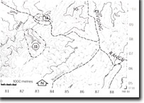
Location: | 835092. 21 kilometres east of Benambra. | |
Abstract: | Exposures of mylonitizied Marengo Granodiorite and minor gold and copper mineralisation. | |
Access: | Tea Pot Creek Track. | |
Ownership: | Crown Land | |
Geology: | Poorly exposed outcrops of mylonitized Marengo Granodiorite occur on the eastern fall into the Tambo River along the Tea Pot Creek Track. Mylonitization has occurred in association with movements on the Indi Fault. Minor gold and copper mineralisation is associated with the fault zone while low-grade cassiterite mineralisation occurs in the Marengo Granodiorite massif. | |
Significance: | Local. This site provides further evidence of the nature and intensity of movement associated with the Indi Fault. | |
Management: | Access to the site should be maintained. | |
References: | Talent, 1973. McAndrew, J. and Marsden, M.A.H. (eds) 1973. Regional guide to Victorian Geology. Second Edition, School of Geology, Uuniversity of Melbourne. | |
© State of Victoria (Agriculture Victoria) 1996 - .

This work, Victorian Resources Online, is licensed under a Creative Commons Attribution 4.0 licence. You are free to re-use the work under that licence, on the condition that you credit the State of Victoria (Agriculture Victoria) as author, indicate if changes were made and comply with the other licence terms.
The licence does not apply to ‘branding’ or some ‘images or photographs’ that may be owned by third parties. We ask you to seek prior approval to use images using the VRO feedback form. Access to higher quality images can also be provided on request.
This page was last updated on .