
8423-20 Mount Elizabeth - Tambo Crossing
|
This information has been developed from the publications:
|
Location: | 823504 to 740595. 13 kilometres south of Ensay. | 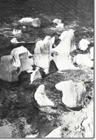 Tambo River. Coalesced potholes in Ordovician sediments. |
Abstract: | Exposure of Snowy River Volcanics and Tambo Crossing and Mount Elizabeth Granodiorite. | |
Access: | Omeo Highway and Collins Road. | |
Ownership: | Crown land in the Mount Elizabeth area, and Private land around Tambo Crossing. | |
Geology: | In the Mount Elizabeth area, Ordovician sediments and Tambo Crossing and Mount Elizabeth Granodiorites have been intruded by east-west trending rhyolite dykes, probably during a very early phase in the explosive eruption of the Snowy River Volcanics and contemporaneous emplacement of the Tambo Crossing and Timbarra Granodiorites. The dykes are exposed in road cuttings on the Omeo Highway and Collins Road. Mount Elizabeth represents the most westerly outlier of the Snowy River Volcanics. The outlier is essentially flat-lying and consists of 530 m of rhyolite and rhyodacite lignimbrite with a 5 m thick ashfall tuff, overlying 15 m of breccia derived mostly from the Ordovician rocks. Recent literature contends that the western boundary of the Mount Elizabeth outlier is not a fault, as is shown on the Bairnsdale 1:250,000 Geological Map Sheet. At approximately the same time as the intrusion of the Tambo Crossing Granodiorite, the Mt Elizabeth Granodiorite, (not shown on the Bairnsdale 1:250,000 map), was intruded into a depression caused by a caldera collapse at Mt Elizabeth. The Mt Elizabeth Granodiorite is the largest intrusion into the Snowy River Volcanics. It is impossible to accurately predict its stratigraphic relationship with the Tambo Crossing Granodiorite, but is probably that they are of the same Lower Devonian age. | |
Geomorphology: | Marked changes in the valley profile of the Tambo River are the prominent physiographic features of this site. The river is confined in a gorge cut in Ordovician sediments north of Tambo Crossing, but the valley broadens in the area of the Tambo Crossing Granodiorite. The granodiorite is evidently less resistant to erosion and its topographic extent is marked by an undulating erosion basin. North of the Tambo Crossing, the Ordovician metasediments strike obliquely across the river channel and erosion along the bedding planes and joint lines has produced a series of coalesced potholes. | |
Significance: | Regional. Mt Elizabeth is the most westerly occurrence of the Snowy River Volcanics. The dyke swarms associated with the intrusion of the granodiorites are of considerable geological interest as their sequence of emplacement is not clear. The site provides an easily accessible example of the varying effects of lithology on stream valley profiles. | |
Management: | Because of the area covered by the site, the value of the significant geological/geomorphological features is unlikely to be seriously affected by localized land disturbance. The sites quality would be enhanced by the maintenance of clear faces on the road cuttings through the Tambo Crossing and Mt Elizabeth Granodiorites. | |
References: | Kok , 1976 Vandenberg, A.H.M., and O’Shea, P.J. 1980. 'Explanatory Notes on the Bairnsdale 1:250,000 geological map'. Rep. geol. Surv. Vict., No.65. | |
Sites 8423 - 20
© State of Victoria (Agriculture Victoria) 1996 - .

This work, Victorian Resources Online, is licensed under a Creative Commons Attribution 4.0 licence. You are free to re-use the work under that licence, on the condition that you credit the State of Victoria (Agriculture Victoria) as author, indicate if changes were made and comply with the other licence terms.
The licence does not apply to ‘branding’ or some ‘images or photographs’ that may be owned by third parties. We ask you to seek prior approval to use images using the VRO feedback form. Access to higher quality images can also be provided on request.
This page was last updated on .