
8423-16 Lake Hill and the Nunniong Plains
|
This information has been developed from the publications:
|
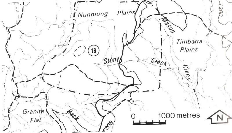
Location: | 830872. 12 kilometres east-south-east of Bindi. | |
Abstract: | Lake and stepped topography on Tertiary Older Basalts. | |
Access: | Lake Hill Track and Nunniong Road. | |
Ownership: | Crown land. | |
Geology/Geomorphology: | Outstanding examples of stepped topography in basalt occur on the slopes of the mesa-like Lake Hill and on the Nunniong Plains. Large scale terraces together with smaller scale features are encountered in all directions on the descent from Lake Hill to the Nunniong Plains. These terraces are in part related to differential erosion along basalt flow boundaries or of softer intervening tuffs, and in part related to frost prising of the steepened inter-terrace slopes. Lake Hill is so named for the lake occurring on its flat lying summit which occupies a primary depression in the basaltic land surface. It is less than 0.7 m deep and the basin is approximately 120 m in length along the longest axis. | |
Significance: | State. Outstanding examples of basalt stepped topography occur in the area. Additionally, lakes formed on Tertiary Older Basalt are uncommon. The nameless lake on Lake Hill is the best example of such a feature in Eastern Victoria. | |
Management: | The stepped topography covers a large area and the geomorphological significance of the site is unlikely to be decreased by localised land disturbance which may result from road construction or extractive industries. The nameless lake on Lake Hill should not be artificially drained and its small catchment should be protected from forestry operations. | |
References: | Talent, J.A. 1965(b). 'The Stratigraphic and diastrophic evolution of Central and Eastern Victoria in Middle Palaeozoic Times', Ibid, 79(1) :179-195. | |
© State of Victoria (Agriculture Victoria) 1996 - .

This work, Victorian Resources Online, is licensed under a Creative Commons Attribution 4.0 licence. You are free to re-use the work under that licence, on the condition that you credit the State of Victoria (Agriculture Victoria) as author, indicate if changes were made and comply with the other licence terms.
The licence does not apply to ‘branding’ or some ‘images or photographs’ that may be owned by third parties. We ask you to seek prior approval to use images using the VRO feedback form. Access to higher quality images can also be provided on request.
This page was last updated on .