
8423-10 Tributary of Old Paddock Creek
|
This information has been developed from the publications:
|
Location: | 745960. 4 kilometres north-east of Bindi. | 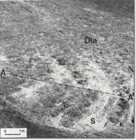 Unconformity (A-A'), between Silurian sediments (S) and Buchan Caves Limestone, (Dla) at Old Paddock Creek tributary. |
Abstract: | Angular unconformity between Buchan Caves Limestone and Silurian sediments. | |
Access: | Walk from Old Hut Creek Track. | |
Ownership: | Private land. | |
Geology: | An angular conformity between Buchan Caves Limestone and Silurian sediments is exposed at this site, where thick, bedded, dark grey Buchan Caves Limestone overlies thinly bedded Silurian siltstone and shales of the Cowombat Siltstone. Towards Mt Walterson, a conglomerate lens in the Cowombat Siltstone is exposed in the creek bed. Two caves are known on the ridge to the north and a breached doline on the spur south of the creek. | |
Significance: | Regional. The relationship between the Buchan Caves Limestone and the Silurian sediments is well displayed at this site. The caves may prove to be more extensive. | |
Management: | Land use which would obscure the outcrop should be prohibited. Small-scale quarrying in the area of the contact would enhance the site by increasing the quality of the display. The management principles outlined for limestone regions apply to this area. | |
References: | Talent, J.A. 1963. 'The Devonian of the Mitchell and Wentworth Rivers', Geol. Surv. Vict., Memoir 24. Vandenberg, A.M.H., Bolger, P., and O’Shea, P.J. 1980. (in press) 'Geology and Mineral Exploration of the Limestone Creek-Reedy Creek Area, North-East Victoria', Geolo. Surv. Vict. | |
Site 8423-6 to 8423-12
© State of Victoria (Agriculture Victoria) 1996 - .

This work, Victorian Resources Online, is licensed under a Creative Commons Attribution 4.0 licence. You are free to re-use the work under that licence, on the condition that you credit the State of Victoria (Agriculture Victoria) as author, indicate if changes were made and comply with the other licence terms.
The licence does not apply to ‘branding’ or some ‘images or photographs’ that may be owned by third parties. We ask you to seek prior approval to use images using the VRO feedback form. Access to higher quality images can also be provided on request.
This page was last updated on .