
8422-12 Bellevue
|
This information has been developed from the publications:
|
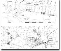
Location: | 530170. 1.5 kilometres north-west of Bairnsdale on northern side of Mitchell River. | |
Geology: | A cliff section in an abandoned quarry displays a gravely shelly and calcareous silt containing well rounded and sorted quartz granules. The gravely material does not occur on the south side of the valley at Pound Swamp and is taken to be a basal gravely facies of the Tambo River Formation named the Wy Yung Gravel Member. | |
Geomorphology: | The pattern of river meandering in the Mitchell Valley is of interest in determining the limit of Holocene marine submergence here. Upstream from Bairnsdale the pattern is intricate, the meanders of low amplitude, and the flood plain contains numerous abandoned channels, ox-bow lakes and point bars. The levees that border the river are low, and irregular and there is only minor back swamp development. By contrast, the channel below Bairnsdale has long, straight or gently curving reaches bordered by high and wide natural levees with a broad back swamp zone. This section of the valley probably represents the extent of former estuarine submergence, the valley fill achieved by deltaic growth of silt jetties rather than by fluvial aggradation. | |
References: | Douglas, J.G. and Ferguson, J.A. (eds) 1976. Geology of Victoria. Geological Society of Australia, Special Publication No.5. Hocking, J.B. 1976. 'Definition and revision of Tertiary Stratigraphic units, onshore Gippsland Basin', Rep. geol. Surv. Vict. No.1976/1. Parker, W. 1978. The Bairnsdale Limestone. Honours Thesis (unpub.) Department of Geology, University of Melbourne. Wilkins, R.W. 1962. Stratigraphy, Sedimentation and Weathering of Tertiary rocks along the northern margin of the Gippsland Basin. M.Sc. Thesis, (unpub.), University of Melbourne. | |
© State of Victoria (Agriculture Victoria) 1996 - .

This work, Victorian Resources Online, is licensed under a Creative Commons Attribution 4.0 licence. You are free to re-use the work under that licence, on the condition that you credit the State of Victoria (Agriculture Victoria) as author, indicate if changes were made and comply with the other licence terms.
The licence does not apply to ‘branding’ or some ‘images or photographs’ that may be owned by third parties. We ask you to seek prior approval to use images using the VRO feedback form. Access to higher quality images can also be provided on request.
This page was last updated on .