
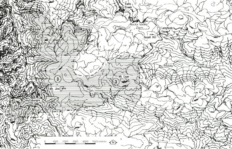
8324-3 Bogong High Plains South
8324-1 to 3 Bogong High Plains
Page top
This information has been developed from the publications:
|
Location: | Eastings 130 to 290, Northings 090 to 200. Includes the areas of Mount Cape, Mount Jim, Cobungra Gap and Mount Loch. | 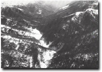 Cobungra Gap (foreground), located in the West Kiewa Thrust Fault crush zone. |
Abstract: | Exposure of High Plains Gneiss and Bogong Volcanics, landforms related to; differential erosion along fault lines, periglacial processes. | |
Access: | Walk from Falls Creek-Omeo Road or from Alpine Road, Mount Hotham. | |
Ownership: | Crown Land. | |
Geology: 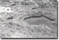 Alpine bog and pool, Bogong High Plains south of Mount Cope. Outcrop of gneissic pegmatite (A) | High plains Gneiss, a “permeation gneiss”, is widespread in the southern High Plains and is characterised by banding and the frequent occurrence of biotite-rich lenses and pegmatite quartz- potash feldspar nodules up to 50 cm long. These rock types are well exposed on Mount Cope. The gneiss of the Mount Cope area contains xenolith, moderately foliated due to a parallelism of biotite flakes. High Plains Gneiss is faulted against Upper Ordovician sediments in the west of the area. These are well exposed on the ridge extending from Mount Loch to Red Robin Mine and consist of steeply dipping quartz sandstones, grey wacks and slates. The dips associated with the Kiewa Thrust Fault. The fault line is marked by a major lineament occupied by the West Kiewa and Upper Cobungra Rivers, which have excavated valleys in a mylonite zone which is up to 1.5 kilometres in outcrop width. These rivers are separated by the low divide of the Cobungra Gap, where shattered chlorotic slates pass into low-grade schists and then into mylonites. The Ordovician sediments and High Plain Gneiss are overlain by Tertiary Older Volcanics (Bogong Volcanics). The basalt of this formation are interbedded with sands, clays, tuffs, and thin bands of lignite, the sediments often contain abundant fossilised plant remains. Basalts are exposed on the Mount Jim- Bundarra Plateau and at Mount Lock. At Mount Jim, seven flows, each separated by tuffs and/or sediments have been recognised. The basal flow is of distinctive composition, consisting of limburgite, which outcrops around the margin of Mount Jim and is best exposed in the northern on the Niggerhead Spur and at Dibbins Lookout. The six overlying flows are olivine basalts. Differential erosion of the softer interbedded tuffs and sediments has produced a “stepped” topography around the margin of the basalt outlier. The basalt at Mount Loch is similar in composition to the upper flows at Mount Jim and displays well developed columnar jointing. Pre-basaltic sediments are exposed in the High Plains Creek and in cuttings on the Cope West Aqueduct, east of Mount Jim. These are lacustrine in type and highly fossiliferous, they consist of partially consolidated sandy clays and shales with intervening thin bands of lignite. Fossil leaf-beds and occasional stumps occur in association with the lower sandy clays, while plant fossils are also common in several of the shale beds. Fossils recorded from the sediments include the gymnosperms phyllocladus, Agathis, and Arancarcia. | |
Geomorphology:  Mount Loch capped by basalt (Older Volcanics). Bogong High Plains in upper left background. | The gently undulating and stepped topography of the High Plain south is in marked contrast with the surrounding deeply dissected areas. The High Plains are characterised by a series of broad alluviated stream valleys, which give way to deeper and narrower valleys of greatly increased gradient down stream from the High Plains margins. This variation is well displayed in the headwaters of High Plain Creek, which drains the basalt-capped Mount Jim Plateau. The Valley sided of this stream and the plateau is marked by stepped topography, which has resulted from differential erosion of the softer tuffs and sediments interbedded with the basalt. The Mount Jim Plateau is separated from the flattened high plain spurs of the Mount Loch- Mount Hotham area by the deep dissected valleys of the Upper Cobungra and West Kiewa Rivers. These river valleys are structurally controlled, having developed along the mylonite crush zone associated with the West Kiewa Thrust. The two rivers are separated by the low drainage divide, Cobungra Gap, resulting from the capture of the West Kiewa Rivers headwaters by the Cobungra River. Landforms occurring on Mount Cope and in the headwaters of Middle Creek have been cited as providing evidence of glacial action on the High Plains. The stream valley heads of this area are marked by shallow cirque-like depressions, which, in some cases, are much wider than the lower stream valleys. A glacial origin has also been inferred to account for the short sections of straight and steep-sided valleys occurring downstream from the depressions. However, the evidence for glaciation is doubtful, features similar to these occurring elsewhere in the High Plains can also be attributed to periglacial processes and stream erosion activity acting upon variations in structure and lithology. More detailed investigations of the High Plains landforms, including detailed geological investigations, are necessary to assess the origin and processes involved in their formation. Periglacial landforms are apparent in the High Plains. Near Mount Jim, arrangements of stone as polygons or rings have accumulated on gentler slopes, these are elongated on the steeper slopes where down slope movements has, on occasion, produced stone stripes. Block streams and glacis together with large rock screes, are a prominent feature of the Cobungra Valley below Mount Loch, while in a shallow depression in the headwaters of Middle Creek, there are small, relict, solifluction lobes. These lobes consists of an accumulation of rocks and regolith derived from high grade schist and gneiss. The long axes of the boulders tend to be oriented down slope, lichen growth on the boulders is limited, suggesting relatively recent movement of the lobes. Sphagnum moss bogs occur in the base of the depressions in this area. Compaction and artificial drainage of the bogs has resulted from trampling, eg. by stock and in place of the thick peaty base there is now gravelly surface. In contrast to the relatively undisturbed bogs occurring on the south-western sides of Mount Cope the area near the Cope West Aqueduct illustrates the instability of the alpine High Plains environment, and indicates that management strategies adopted for the area must take into consideration the potentially destructive effects of various land uses. | |
Significance: | As indicated in the Introduction to the Bogong Map sheet, management strategies should be oriented towards the preservation of vegetation. Vegetation cover is the major factor, which preserves many of the features of significance, and in consequence, any land use that may damage vegetation will degrade the quality and significance of these sites. Features of special interest, such as the stone rings at Mount Jim, the solifluction lobes at Middle Creek and the fossils sites in High Plains Creek, could be easily destroyed by inappropriate siting or roads, walking tracks or extractive industries. The fossil sites at present receive some measure of protection because, although close to a road, motor vehicle access to the area of the site is restricted by the S.E.C. | |
Management: | National. This area includes the best example of High Plains occurring in Victoria, and represents a substantial part of one of the major alpine and sub-alpine environments of continental Australia. Distinctive types of High Plains Gneiss are exposed on Mount Cope, while in the Mount Him and Mount Lock areas the Bogong Volcanics, together with the intercalated and pre-volcanic sediments are exposed. Landforms related to differential erosion along fault lines and consequent stream capture occur at Cobungra Gap, while well developed stepped topography, occurs in the Mount Jim and in the head of Middle Creek, while bog-peat environments of importance occur throughout the area, particularly on Mount Cope. | |
References: | Crohn, P.W. 1950. 'The geology, petrology and physiography of the Omeo District, North-Eastern Victoria', Proc. R. Soc. Vict., 62 :1-70. Carr, S.G.M. and Costin, A.B. 1955. 'Pleistocene glaciation in the Victorian Alps', Proc.Linn. Soc. N.S.W., 80 :217-228. Beavis, F.C. 1959. 'Pleistocene glaciation on the Bogong High Plains', Aust. J. Sci. 21 :192. Beavis, F.C. 1962. 'The geology of the Kiewa area', Proc. R. Soc. Vict. 75 :349-510. Costin, A.D. 1957. 'Further evidence of Pleistocene glaciation in the Victorian Alps', Proc. Linn. Soc. N.S.W., 82 :233-238. Peterson, J.A. 1971. 'The equivocal extent of glaciation in the southeastern uplands of Australia', Proc. R. Soc. Vict., 84 :207-211. | |
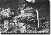 Pre-basaltic sandstones, mudstones and lignites (A) exposed in the Cope West Aqueduct. | 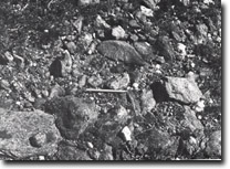 Detail of material comprising lobes. | 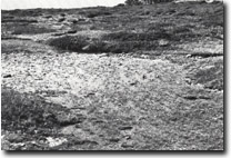 Severely disturbed alpine bog, north of Mount Cope. |
© State of Victoria (Agriculture Victoria) 1996 - .

This work, Victorian Resources Online, is licensed under a Creative Commons Attribution 4.0 licence. You are free to re-use the work under that licence, on the condition that you credit the State of Victoria (Agriculture Victoria) as author, indicate if changes were made and comply with the other licence terms.
The licence does not apply to ‘branding’ or some ‘images or photographs’ that may be owned by third parties. We ask you to seek prior approval to use images using the VRO feedback form. Access to higher quality images can also be provided on request.
This page was last updated on .