
8322-7 Tabberabbera
|
This information has been developed from the publications:
|
Location: | 305430. Lower Reaches of Swamp Creek, Wentworth River and the Mitchell River between Bull Point and the junction of Sydney Creek. | 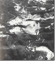 Mitchell and Wentworth rivers at Tabberabbera. Cut-off meander (A) |
Abstract: | Exposures displaying the lithology, structure and fossil assemblages of the Wentworth Gorge and Ordovician sediment. Alluvial terraces, and cutoff meander. | |
Access: | Tabberabbera Road. | |
Ownership: | Private land around Scrubby Creek, Crown land (some private land acquired by State Rivers and Water Supply Commission) on Mitchell River. | |
Geology: | Ordovician sediments surround the Wentworth group in the Tabberabbera Area. The lithology of the sediments ranges in composition from medium grained quartz sandstones, silty sandstones, sand siltstones and silty claystones. These sediments are generally unfossiliferous although graptolites have been recorded at several localities in association with clayey siltstones, silty claystones and cherty black siltstones. Graptolites collected from a road cutting exposure in cherty Ordovician sediments, approximately 500 metres west of Tabberabbera Road crossing over the Wentworth River (F) includes species of Climacograptus, Crytograptus, Dicellograptus, Diplograptus, Glossograptus and Leptograptus which are indicative of Lower Gisbornian age. Wentworth Group Sediments are exposed in Swamp Creek, in cuttings on a private road connecting Tabberabbera Road with the Lower Dargo - Tabberabbera Road in Hundred Acre Creek and in the Mitchell River. Conglomerates and coarse quartz sandstones of the Wild Horse Formation are exposed in road cuttings towards the ridge top west of Swamp Creek on the above named track. These unconformably overlie Ordovician sediments and pass into the coarse basal sandstones of the Kilgower member closer to Scrubby Creek. Fine and coarse sandstones, and mudstones of the Kilgower Member are exposed in the channel of Swamp Creek while siltstones and claystones interbedded with banks of impure limestone are exposed on slopes to the east of Scrubby Creek and in a road section on the ridge top. These sediments contain Hysterolites, Bucanathryis, and occasional Tentaculites (F). The Kilgower Member overlies the Dead Bull Member, and this sequence is displayed in Hundred Acre Creek and its tributary, Gap Gully. The Dead Bull Member at this locality consists of poorly bedded clayey siltstones and silty claystones with local development of calcareous siltstones and marls. Outcrops of this member are very poor with only small exposures occurring in the creek channel. The lower sandstone unit of the Kilgower Member is exposed in the upper reaches of Hundred Acre Creek. These are similar to those described in Sandy Creek, although they include several prominent limestone beds, seamed by dykes, but which display little noticeable metamorphism. The dykes have been contaminated to varying degrees with calcite. The lower sandstone unit gives way to finer grained sediments and these are relatively well exposed in an old cutting just north of Hundred Acre Creek, on the east side of the Mitchell River. At this locality, lower sandstones are succeeded by fossiliferous siltstones and claystones, (F), which then pass into the upper sandstone unit. Sediments of the overlying Roaring Mag Member are well exposed in cliffs on the northern side of Horseshoe Bend and in the Mitchell River, north to Hundred Acre Creek. At these localities, fossiliferous claystones and siltstones, (F), with minor intercalations of dark limestone are exposed. In the vicinity of the junction of the Wentworth and Mitchell Rivers, the gently southward pitch of the Mitchell Syncline abruptly steepens. Associated with this abrupt increase in pitch is considerable structural complexity. There are a few exposures which display the complex structural relationships, the most instructive exposure occurs opposite Horseshoe Bend. At this locality, faulted Ordovician sediments are exposed. The overlying Wild Horse Formation is overturned and is extensively faulted and fractured. The adjacent outcrops of the Kilgower Member are also sheared and faulted for approximately 140 metres upstream. The Wentworth Group sediments are intruded by a series of dykes. The most prominent are of quartz diorite, hornblende porphyrite and quartz feldspar porphyrite composition. The largest of these, the Angusvale Diorite is exposed in cliffs of the Mitchell River to the north of Horsehoe Bend. To the north of the Angusvale Diorite, volcanics and sediments of the Avon River Group predominate. Wellington Rhyolite is well exposed in the bed of the Mitchell River at Slalom Rapids, (A). These beds dip at approximately 5 degrees to the south and are characterized by abundant geodes, many of which contain chalcedony and clusters of well developed, small, quartz crystals. These rhyolites are overlain by Mount Kent Conglomerate that contact being clearly visible in the stream-side cliffs. | |
Geomorphology: | Lithological variations have markedly affected the valley profiles of the Mitchell River in this area. The valley sections in Ordovician sediments are characterised by entrenched meanders with steep, vegetated slopes and discontinuous cliffed sections. The valley shape changes abruptly on entering the less resistant Wentworth Group sediments where it is characterised by relatively gently sloping valley sides with the deposition of pockets of alluvium. This gently undulating terrain gives way to gorge topography in the south where the Mitchell crosses the sediments and volcanics of the Avon River Group. Within the area of Wentworth Group, pocket alluvium and a high level alluvial terrace are prominent. An abandoned, spurred meander occurs north of the junction of the Wentworth and Mitchell Rivers. This meanders was once occupied by the Mitchell River, subsequent erosion has truncated the meander neck, diverting the river and isolating the meander. A similar spurred meander occurs at Horseshoe Bend, although meander neck erosion has not, as yet, truncated the feature. | |
Significance: | State. This site displays representative exposures of the Wild Horse Formation sediments and the Dead Bull Member sediments of the Tabberabbera Formation. The lithology of the Kilgower and Roaring Mag Members of the Tabberabbera Formation are well exposed and contain several important fossil sites. Of particular significance are the exposures of the Wentworth Group at Horseshoe Bend, which display the structural complexity arising from the rapid increase in pitch of the Mitchell Syncline. The site also includes the largest representative of the Tabberabbera Dyke Swarm, the Angusvale Diorite. The variations in valley shape related to varying lithologies, the abandoned spurred meander and the as yet unbreached Horseshoe Bend spurred meander provide an interesting geomorphologic contrast. | |
Management: | The proposed Mitchell River Dam pondage will obscure all the low-lying areas upstream from the Angusvale Diorite. As a consequence, the structurally important section of Horseshoe Bend, several fossil sites the geomorphologic ally significant river valley forms will be obscured. | |
References: | Talent, M.M. 1963. 'The Devonian Brachiopods and Pelecypods of the Buchan Caves Limestone, Victoria', Proc. R. Soc. Vict., 68-70 :1-61. | |
8322 4-7
© State of Victoria (Agriculture Victoria) 1996 - .

This work, Victorian Resources Online, is licensed under a Creative Commons Attribution 4.0 licence. You are free to re-use the work under that licence, on the condition that you credit the State of Victoria (Agriculture Victoria) as author, indicate if changes were made and comply with the other licence terms.
The licence does not apply to ‘branding’ or some ‘images or photographs’ that may be owned by third parties. We ask you to seek prior approval to use images using the VRO feedback form. Access to higher quality images can also be provided on request.
This page was last updated on .