
8322-4 Mitchell River Gorge
|
This information has been developed from the publications:
|
Location: | 310325 - 329235. The Mitchell River Valley between the junctions of Cobbannah River and Raymond Creek. | 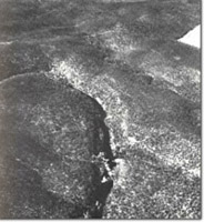 Mitchell River Gorge near Glenaladale |
Abstract: | River gorge and exposures of the upper units of the Avon River Group. | |
Access: | Mitchell Road, Billy Goat Bend Road or Adam Track. | |
Ownership: | Crown land. | |
Geology: | Between Cobbannah River and Raymond Creek the Mitchell River flows through a gorge cut predominantly in Upper Devonian - Lower Carboniferous sediments. However, at the junction of Pat Kellys Creek and the Mitchell, an inlier of Middle Devonian sediments outcrops in the river and in channel-side cliffs. The cliffs display tightly contorted dark fossiliferous slates, grits and shales which are overlain by brecciated conglomerates of the Upper Devonian Mount Kent Conglomerate. Downstream from this locality, cliff sections demonstrate the current bedded nature of the Upper Devonian-Lower Carboniferous strata which consist of siliceous sandstones and conglomerates with minor beds of shale and red or purplish mudstones. These are well exposed in the lower section of the gorge between the old Glenaladale weir and Raymond Creek where finer grained sediments are characteristic of the Snowy Plains Formation. The Upper Devonian - Lower Carboniferous sedimentary sequence exposed in the gorge dips gently, (less than 5o), to the south or south west. Adjacent to the old Glenaladale weir, shales and mudstones are exposed in cliffs and occur as boulders and fragments of Lepidodendron occur in brown-grey mudstones while Archaeopteris sp. has been recorded from the carbonaceous shales. Pleistocene high level alluvium caps the Devonian sedimentary sequence at Billy Goat Bend and between Rosevale Creek and Raymond Creek. These consist of coarse gravels and sand with occasional remnants of silicified wood. | |
Geomorphology: | The prominent physiographic feature of this area is the cliff lined gorge of the Mitchell River. The gorge has formed rapid down cutting through conglomerates and sandstones of the Avon River Group and is contrasted with the undulating relatively gently sloping and wider valley sections cut in less resistant Middle Devonian sediments to the north, and the broad alluvial plains cut in Tertiary and Pleistocene unconsolidated sediments to the south. The gorge is characterized by large entrenched meanders which concentrate flood discharges and rapidly remove weathered debris maintaining undercut river side cliffs and steep valley side slopes. Large landslides are consequently prominent. Particularly good examples occur in the area of Pat Kelly Creek where a small quartz feldspar intrusion is observed by a large landslide. The toe of another landslide, 30 - 40 hectares in extent, has diverted the Mitchell River into the opposite bank resulting in an over steepened cliff approximately 150 metres in height. The cliffs are characterized by ledges and small caverns highlighting the effects of differential weathering and erosion while the deeply incised tributary streams are characterized by waterfalls and gorges which contain a rainforest flora distinctive in this part of Victoria. The rugged relief of the Mitchell River Gorge and associated tributary gorges produced a topography of spectacular scenic quality. | |
Significance: | State. The Mitchell River Gorge is an easily accessible and prominent feature which displays the characteristic incised nature of the major south flowing river of Central-East Victoria. It provides one of the best exposures of the upper units of the Avon River Group and contains several fossil sites. The rugged topography and associated floral characteristics have a high recreational value, as evidenced by the large numbers of canoeists and walkers who use the area annually. | |
Management: | The scientific and scenic quality is dependent on the maintenance of the Mitchell River Gorge and tributary gorges. Construction of large reservoirs which would flood the gorge and obscure outcrop would seriously degrade the significance of the site. The spectacular scenic qualities could be seriously degraded by the removal of vegetation or the construction of artificial structures which would impinge upon the visual landscape of the area. | |
References: | Easton, J.G. 1938. 'The geology and physiography of the Mitchell River Gorge', Min. geol. J. Vict., 1(3) :73-75. | |
8322 4-7
© State of Victoria (Agriculture Victoria) 1996 - .

This work, Victorian Resources Online, is licensed under a Creative Commons Attribution 4.0 licence. You are free to re-use the work under that licence, on the condition that you credit the State of Victoria (Agriculture Victoria) as author, indicate if changes were made and comply with the other licence terms.
The licence does not apply to ‘branding’ or some ‘images or photographs’ that may be owned by third parties. We ask you to seek prior approval to use images using the VRO feedback form. Access to higher quality images can also be provided on request.
This page was last updated on .