
8322-2 Avon River - Stratford
|
This information has been developed from the publications:
|
Location: | 060980. Avon River channel from Stratford to four kilometres north-west of the Avon Bridge at Stratford. | 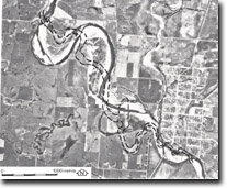 Course changes of the Avon river at Stratford. Dotted line shows survey course 1850-1860. |
Abstract: | Changes in channel form of the Avon River. | |
Access: | Walk south from Stratford/Bushy Park Road. | |
Ownership: | Private land, some Crown land. | |
Geomorphology: | The Avon River valley at Stratford is entrenched into earlier alluvial deposits of sands and silts with minor gravel lenses. These deposits are up to 20 metres thick near Stratford, the upper section exposed in river cliffs commonly being a red-brown colour. Comparison of recent aerial photos with maps made between 1850 - 1860 indicate there has been extensive change in the position and nature of the river channel. From a narrow stream with steep forested banks in the mid 19th century, the Avon has become shallow, gravely and conspicuously braided with sweeping meander curves. Undercut banks alternate with wide, sandy and gravely point bars and frequent shifts in the position of the main channel occur. | |
Significance: | Regional. The extensive erosion of the Avon flood plain over the last 100 years is related to intensive clearing and settlement of the area. It demonstrates the impact of man on river systems. | |
Management: | Limited removal of gravels from the channel would not detract from the interest of the site. | |
References: | Jenkin, J.J., 1968. 'The geomorphology and Upper Cainozoic geology of Southeast Gippsland, Victoria', Geol. Surv. Vict. Memoir 27. | |
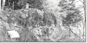 Gravels (A). Avon River cliffs, north of Stratford. (Source: Tran Dang-Dai) |
© State of Victoria (Agriculture Victoria) 1996 - .

This work, Victorian Resources Online, is licensed under a Creative Commons Attribution 4.0 licence. You are free to re-use the work under that licence, on the condition that you credit the State of Victoria (Agriculture Victoria) as author, indicate if changes were made and comply with the other licence terms.
The licence does not apply to ‘branding’ or some ‘images or photographs’ that may be owned by third parties. We ask you to seek prior approval to use images using the VRO feedback form. Access to higher quality images can also be provided on request.
This page was last updated on .