
8321-1 Redbank
|
This information has been developed from the publications:
|
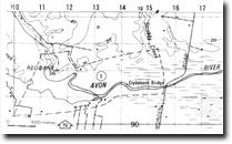
Location: | 115916. Avon River four kilometres upstream from Clydebank Bridge. | 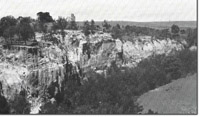 Cliffs in Nuntin Clay Member at Redbank, (Source: Tran Dang-Dai). |
Abstract: | Tertiary outcrop; changes in channel morphology. | |
Access: | Bengworden Road and Stratford - Redbank Road. | |
Ownership: | Private land. | |
Geology: | Cliffs along the Avon River near Redbank, expose beds of non-marine clays and silts. The material is grey to yellow, mottled and ferruginized, and contains only a small sand fraction. The beds were originally designated as the upper unit of the Boisdale Beds, but are now referred to as the Nuntin Clay Member of the Boisdale Formation. They are regarded as Pliocene in age and represent the first continental deposits that followed the marine transgression in the early to middle Pliocene. In the Stratford area, the Nuntin Clay Member is overlain unconformably by the Haunted Hill Gravel. | |
Geomorphology: | The Avon River flood plain near Redbank occupies a tract averaging 1.5 kilometres in width with well defined valley-side bluffs. The present channel lies on the eastern side of the flood plain and recent trimming of the bluff exposes the Tertiary sediments in river cliffs. There are very few cut-off meanders on the flood plain, although an anabranch channel follows the western side of the valley to rejoin the main stream two kilometres below Redbank. The Avon is notable for the abundant coarse sediments of the channel and flood plain, and the conspicuous braiding that extends from Redbank downstream beyond the Clydebank Bridge. The channel sediments are of cobbles, gravel and sand with little silt or clay material. Comparison with historical records indicates that channel braiding and bank erosion is a product of the past 100 years, and is probably due to increased erosion of the areas adjacent to the flood plain following clearing for closer settlement. During the 19th Century, Redbank was a steamer landing point, but the river upstream from Clydebank Bridge is now so shallow that it is no longer navigable, every by small boats. | |
Significance: | Regional. The outcrop of Tertiary sediments is the major exposure of the Nuntin Clay Member in the Sale - Stratford area. The braided reach of the Avon River is markedly different from the channel pattern of adjacent rivers and the causes of this development need to be investigated in detail. | |
Management: | Access to the cliffed exposures should be maintained. | |
References: | Jenkin, J.J. 1968. 'The geomorphology and Upper Cainozoic geology of Southeast Gippsland, Victoria', Geol. Surv. Vict. Memoir 27. Hocking, J.B. 1976. 'Geology of Lower Miocene calcareous deposits in the Sale-Yarram Region, South Gippsland', Min. geol. J. Vict., 6(6) :80-90. | |
Site 8321-1
© State of Victoria (Agriculture Victoria) 1996 - .

This work, Victorian Resources Online, is licensed under a Creative Commons Attribution 4.0 licence. You are free to re-use the work under that licence, on the condition that you credit the State of Victoria (Agriculture Victoria) as author, indicate if changes were made and comply with the other licence terms.
The licence does not apply to ‘branding’ or some ‘images or photographs’ that may be owned by third parties. We ask you to seek prior approval to use images using the VRO feedback form. Access to higher quality images can also be provided on request.
This page was last updated on .