
8223-3 Bryce Plain and Bryce Gorge
|
This information has been developed from the publications:
|
Location: | 790730. 17 kilometres south-east of Mt Howitt. | 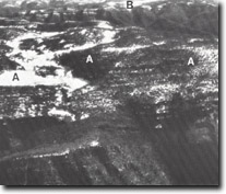 Bryce plain (A). Howit Plain (B). |
Abstract: | Exposures of Snowy Plain Formation and intercalated basalt flows. High altitude plain partially capped with basalt, escarpment, river gorge and waterfalls. | |
Access: | Howitt Road. | |
Ownership: | Crown land with small enclave of private land. |
| Geology: | Upper Devonian - Lower Carboniferous sediments of the Snowy Plains Formation are exposed in Bryce Gorge. This formation is distinguished from the underlying Mt Kent Conglomerate by the absence of pebbly sandstone and conglomerate beds and by the general trend from coarse to fine sandstone. Purple fine-grained sandstones, silty sandstone and red mudstone outcrop in the cliffed escarpment which heads Bryce Gorge. These sediments dip to the west and north-west at angels between 30 degrees and 40 degrees. In the lower sections of the gorge sandstone is interbedded with prominent basalt flows. The basalt is well-jointed, the joints often filled by chalcedony, quartz and epidote. West of Bryce Gorge the deeply dissected topography gives way to a gently undulating plain which is capped by Tertiary Older Basalt. |
Geomorphology: | The gently undulating Bryce Plain is situated at an altitude of between 1400 and 1500 m. It is capped by basalt, a factor which has led to its preservation form deep incision. The plain is bounded on the east by a steeply sloping and cliffed escarpment over which Conglomerate and Pieman Creeks plunge in spectacular waterfalls approximately 100 m in height. These creeks have excavated a gorge section (Bryce Gorge) bounded for the most part by cliffs. These cliffs clearly display the bedding of the Upper Devonian sediments and differential weathering and erosion of these beds has produced sloping and benched cliff forms. Many of the benches are covered by scree. A small fen at G.R. 777685 may prove to be one of the most significant sites for palaeo-environmental studies (particularly palynology) in the south eastern highlands. |
Significance: | State. The partially dissected undulating surface of Bryce Plain distinguishes the basalt topography from that of the Howitt Plains. Deeply dissected topography characterized by cliffed and gorge sections on creeks and rivers is typical of the landforms occurring on the sandstone of the Snowy Plains Formation. Bryce Gorge is a representative example of these landscapes. |
Management: | The comments regarding site 8322-1 apply also to this locality. The fen at G.R. 777685 is very sensitive to disturbance of its surface and catchment area. Grazing, roadworks and forest operations should be excluded from that catchment. |
References: | Joyce, L. 1979. The Late Quaternary History of Caledonia Fen - Snowy Plains Region - Central Eastern Victoria. Honours thesis (unpublished), Geography Department, Monash University. |
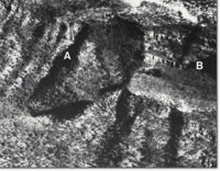 Bryce gorge. Pieman Creek (A). Conglomerate Creek (B). | |
© State of Victoria (Agriculture Victoria) 1996 - .

This work, Victorian Resources Online, is licensed under a Creative Commons Attribution 4.0 licence. You are free to re-use the work under that licence, on the condition that you credit the State of Victoria (Agriculture Victoria) as author, indicate if changes were made and comply with the other licence terms.
The licence does not apply to ‘branding’ or some ‘images or photographs’ that may be owned by third parties. We ask you to seek prior approval to use images using the VRO feedback form. Access to higher quality images can also be provided on request.
This page was last updated on .