
8223-1 Mount Howitt Area
|
This information has been developed from the publications:
|
Location: | 686855. 45 kilometres east of Mansfield. | 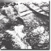 Mount Howitt to Mount Marjorie. Escarpment of the Avon River Group |
Abstract: | Exposures of Upper Devonian - Lower Carboniferous sediments. Peaks, escarpments, deeply dissected topography and periglacial landforms. | |
Access: | Howitt Road. | |
Ownership: | Crown land. | |
Geology: 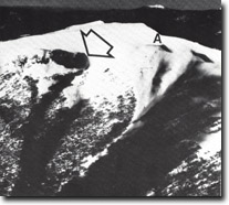 South-eastern slope, Mount Howitt. Nivation hollow (arrowed). Photographed in July 1980. | Excellent exposures of the Lower Carboniferous Snow Plains Formation occur in the north-facing cliffs between Mt Marjorie and Mt Howitt. These beds dip to the north at between 20 degrees and 25 degrees consist predominantly of quartzose and felspathic sandstone and siltstone with minor amounts of gritty sandstone and conglomerates. The gritty sandstones and conglomerates are more common toward the base of the sequence. The Lower Carboniferous sediments overly biotite rhyodacite, mudstones and fine arkoses and boulder conglomerates of the Upper Devonian sequence. These are particularly well exposed in the north-facing scarp below and to the west of Mt Marjorie. This sequence is notable for the massive boulder beds occurring near its base, and the rich and diverse fish fossil fauna recovered from the lower fine-grained sediments. The fossil site is located at the base of Howitt Spur and includes complete and articulated skeletal material. Crossopterygians are represented by isolated teeth and scales of proteiforms and three types of Acanthodians and two forms of palaeoniscids have been recorded. Dipnoans of two types are commonly preserved as entire specimens while several forms of placoderms are also present. Regional folding is absent in the Upper Devonian - Lower Carboniferous sediments and intercalated volcanics. However, localised folding, into two synclines and an anticline occurs in The Pimple - Mt Hewitt - Mt Speculation area. These fold structures tend to reflect bedrock structure and are better regarded as a fault-folded or monocline in which localised compression may have played a part. Folding associated with the Speculation Syncline is apparent in the northern slopes of Mt Howitt and the razor back ridge, known as the Cross Cut Saw has formed along the western limb of this syncline. | |
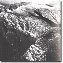
Geomorphology:  Crosscut Saw to Mount Speculation. Escarpment to the Avon River Group. | Deep incision by the Howqua River to the north of Mt Marjorie has produced a steep bluff which is lined by high cliffs cut in Lower Carboniferous sandstones and gritty sandstones. The bedding of the sequence dips to the south and this resulted in a cuesta form ridge with steep north-facing escarpments and prominent dip (e.g. Hells Window) producing deep fissures. The formation of these features has been attributed to erosion by ice-chutes although periglacial processes together with stream erosion and mass wasting could be responsible for their formation. Deep incision by the Howqua River to the west and the tributaries of the Wonnangatta River to the east have produced a rugged razorback ridge, the Cross Cut Saw. Several steeply sloping steeped ridges extend down into the valley of the Wonnangatta River. The most prominent of these is the Devils Staircase, so names for its pronounced steeped appearance. The stepping or benching is related to variation in lithology, the steps forming on the more erosion-resistant beds. Mt Howitt with an elevation of 1742 m is the highest peak in the long arc of mountains stretching from Mt Cobbler to The Bluff. The north-eastern slopes of Mt Howitt are broken by two steep-sided depressions which have been regarded as glacial cirques or nivation hollows. Striations occurring in the headwalls of these features were though to suggest a glacial origin although recent work has indicated that at least some of the striations result from contemporary mass movement of snow. Further detailed work is necessary to establish whether these features are of glacial origin, or whether they result from frost action and mass wasting beneath a snow bank (nivation cirque). | |
Significance: | National. Excellent exposures of the lithologies and structures and representative fossil sites of the Upper Devonian - Lower Carboniferous occur on the escarpment and Howqua Valley. The highly dissected topography, the peak form of Mt Howitt and the -associated glacial-periglacial features are of considerable interest geomorphologically, and are an important component of the Australian alpine landscape. | |
Management: | It is emphasized that this area is of considerable scientific interest and also one of spectacular scenic quality. It is recommended that visually discordant elements such as roads, quarries, and transmission towers and lines should be located below the sub-alpine zone. Means of reducing the evident erosion on walking tracks and cattle trails need to be investigated in detail, The above measures should assist in the preservation of the important glacial-periglacial features described. | |
References: | Costin, A.B. 1957. 'Further evidence of Pleistocene glaciation in the Victorian Alps', Proc. Linn. Soc. N.S.W., 82 :233-238. McAndrew, J. and Marsden, M.A.H. (eds) 1973. Regional Guide to Victorian Geology. Second Edition, School of Geology, University of Melbourne. Peterson, J.A. 1971. 'The equivocal extent of glaciation in the southeastern uplands of Australia', Proc. R. Soc. Vict., 84 :207-211. | |
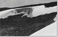 Ground photograph of small nivation hollow, October 1980. | 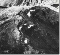 Mount Howitt. Naviation hollow with residual snow patches November, 1980 | |
 Sites 8223-1 to 8223-2 |
|
© State of Victoria (Agriculture Victoria) 1996 - .

This work, Victorian Resources Online, is licensed under a Creative Commons Attribution 4.0 licence. You are free to re-use the work under that licence, on the condition that you credit the State of Victoria (Agriculture Victoria) as author, indicate if changes were made and comply with the other licence terms.
The licence does not apply to ‘branding’ or some ‘images or photographs’ that may be owned by third parties. We ask you to seek prior approval to use images using the VRO feedback form. Access to higher quality images can also be provided on request.
This page was last updated on .