
8222-2 Lake Tali Karng
|
This information has been developed from the publications:
|
Location: | 811445. 17 kilometres north-east of Licola. | 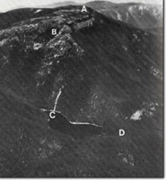 Gable End (A). The Sentinels (B). Lake Tali Karng (C). Position of landslide (D) |
Abstract: | Deep, permanent lake formed by the damming of the Nigothoruk Creek by a landslide. | |
Access: | Moroka Road from Licola to McFarlanes Saddle then walk along closed 4WD track. Moroka Road from Licola to Wellington River then along Wellington River Track, closed 4WD track, to Echo Point. | |
Ownership: | Crown land. | |
Geology: | Lake Tali Karng is located within the Upper Devonian Wellington Rhyolite of the Avon River Group, with a narrow south-westerly trending band of conglomerates, sandstones and siltstones of the Moroka Glen Formation outrcropping at the western end of the lake. Landslide debris of Recent age forms a natural rock dam at the western end of the lake separating the waters of Tali Karng from the Valley of Destruction. | |
Geomorphology: | Unique within the Victorian highlands and situated at about 900 m above sea level, Lake Tali Karng is the only permanent, deep, highland lake in Australia that is not of glacial or volcanic origin. The lake has a surface area of approximately 16 hectares and is a maximum of 51 m in depth. The shoreline of the lake is generally steep and rocky. A landslide at the western end of the lake , now estimated to have occurred 1500 years ago (P. Kershaw, per comm), caused the damming of Nigothoruk and Nightingale Creeks and resulted in the formation of the lake. | |
Significance: | National. Lake Tali Karng is the only deep highland lake in continental Australia that is not of glacial or volcanic origin. | |
Management: | The character of the site is dependent on the maintenance of the lake’s unique hydrology. It is stressed that any land use which could detrimentally affect either the quality or quantity of the water should be avoided. Vegetation disturbance within the catchment of the lake by logging and further access-track construction could result in the initiation of soil erosion by gullying and/or reactivation of potential landslide areas around the lake. An assessment needs to be made of the present, and predicted, impact of unrestricted visitor access to camping sites around the lake, particularly in relation to the disposal of solid and liquid wastes. | |
References: | Timms, B.V. 1974. 'Aspects of the Limnology of Lake Tali Karng Victoria', Ibid. 25 :273-279. Joyce, E.B and King, R.L. (eds). 1980. Geological features of the National Estate in Victoria. An inventory compiled for the Australian Heritage Commission. Geological Society of Australian (Inc.), Victorian Division. | |
Sites 8222- 1 3
© State of Victoria (Agriculture Victoria) 1996 - .

This work, Victorian Resources Online, is licensed under a Creative Commons Attribution 4.0 licence. You are free to re-use the work under that licence, on the condition that you credit the State of Victoria (Agriculture Victoria) as author, indicate if changes were made and comply with the other licence terms.
The licence does not apply to ‘branding’ or some ‘images or photographs’ that may be owned by third parties. We ask you to seek prior approval to use images using the VRO feedback form. Access to higher quality images can also be provided on request.
This page was last updated on .