
Wollaston (Wo)
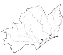 | Area: 28 sq. km (0.1%) Wollaston land system is found in the area surrounding the Gippsland Lakes in association with Clydebank and Morass land systems. The main components are sand dunes and intervening, often swampy, flats similar to, though smaller than, swamps mapped in Morass land system. The geomorphic history is obscure. The dunes are possibly the result of reshaping of the prior and inner barrier systems during the last major sea level fall. The intervening flats may have a more recent lacustrine or paludal origin. Wollaston and Tyers land systems are similar in that they are composed of dunes with intervening flats but they differ in geomorphic history and Wollaston has a slightly drier climate. Where the sands are deep, the soils are acidic, infertile and droughty, with dark topsoils and bleached subsurfaces. Iron and/or humus-enriched pans occur at depth. Elsewhere, clays and silts underlie a relatively thin cover of sand, producing duplex soils with mottled, sodic clay subsoils. | 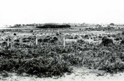 Low dunes and relict lacustrine flats with Melaleuca ericifolia (swamp paper-bark) growing in wet depressions |
| The vegetation on the dunes is a ferny open woodland I dominated mainly by E. viminalis var. racemosa and Banksia spp. The less sandy swales carry a woodland I of E. tereticornis. The deeper depressions, which are often inundated, have a zonation of vegetation towards the centre. | ||
| CLIMATE Rainfall, mean (mm) Temperature, mean (°C) Seasonal growth limitations | Annual 500 - 800; lowest January (30 - 50), highest October (40 - 70) Annual 12 - 14; lowest July (9 - 10), highest February (19 - 20) Temperature <10°C (av.): July Rainfall < potential evapotranspiration: November – March |
| GEOLOGY Age, lithology | Pleistocene barrier deposits of sands; Holocene lacustrine fill of sands and clays and minor paludal fills |
| PHYSIOGRAPHY Landscape Elevation range (m) Relative relief (m) Drainage pattern Drainage density (km/km2) | Sand dunes and intervening flats and stranded beach lines 0 - 20 0 - 20 Deranged 0.1 |
| PRESENT LAND USE | Mostly uncleared: areas in The Lakes National Park, Lake Coleman, Dowd Morass and Blond Bay State Game Reserves; apiculture; grazing of sheep and cattle (limited) |
 | 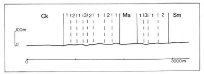 |
| LAND COMPONENT Percentage of land system Diagnostic features | 1 45 Dunes | 2 45 Relict lacustrine flats and stranded beach lines | 3 10 Depressed, wet, saline, inter-dune areas |
| PHYSIOGRAPHY Slope %, typical and (range) Slope shape | 5- 10, (2- 15) Convex | <1, (0- 2) Straight | <1, (0- 2) Concave |
| SOIL | |||
| Parent material | Wind-sorted sand of marine origin | Lacustrine sand and clay | Wind-sorted sand of marine origin |
| Description | Single observation but predictably dark sand over grey sand with coffee rock or bright yellowish brown sand below | Single observation — black sand over grey sand with mottled alkaline clay below. Possibly other soils | No observations — probably black acid sand over grey sand, possibly with coffee rock at depth where water table is deeper |
| Classification | Podzols Uc4.32 or Uc4.22 | Solodic Soils Dy5.23 | Humic Gleys, possibly some Podzols - |
| Surface texture | Sand | Loamy fine sand | Sand |
| Surface consistence | Loose or soft | Soft | Soft |
| Depth (m) | >2.0 | >2.0 | >2.0 |
| Nutrient status | Very low | Low | Very low |
| Available soil water capacity | Very low | Low | Low |
| Perviousness to water | Very rapid | Slow | Very rapid |
| Drainage | Somewhat excessive | Poor to somewhat poor | Very poor to poor |
| Exposed stone (%) | 0 | 0 | 0 |
| Sampled profile number | - | - | - |
| NATIVE VEGETATION Structure of vegetation and characteristic species of dominant stratum (+ Predominant species) | Ferny open woodland I: E. viminalis var. racemosa+ with Banksia serrata+ or B. integrifolia (near lake shore) and Pteridium esculentum | Woodland I: E. tereticornis+ | Zonation of vegetation with, from margins inwards: Closed scrub of Melaleuca ericifolia+ Rushland of Juncus maritimus+ Herbfield of Salicornia spp.+ Centres often with free water |
Disturbance | Affected process and trend | Primary resultant deterioration | Causal activities | Primary off-site process | ||
Form | Susceptibility of components | Incidence within components | ||||
| Alteration of vegetation: — reduction in leaf area, rooting depth and/or perenniality | Reduced transpiration, resulting in increased deep percolation and leaching | Nutrient loss | 1; high | Not determined | Removal of trees | Increased movement of water to groundwater; increased base-flow of streams |
| Increased exposure of surface soil | Increase wind velocity over soil and increased detachment of sand | Wind erosion | 1; high | Uncommon; local occurrence | Clearing, burning, road building and other earth-moving activities, trafficking by stock and vehicles. | Encroachment by sand |
| Increased physical pressure on soil | Increased compaction | Structure decline | 1; very low 2; low 3; low - moderate | Uncommon | Increased trafficking, cultivation, overgrazing, export of organic matter | - |
| Increased soil disruption | Increased loosening of sand | Wind erosion | 1; high | As for wind erosion above | As for wind erosion above | Encroachment by sand |
| Comments: Regeneration of vegetative cover on the dunes is usually slow because of soils with low fertility and exposure to wind | ||||||
© State of Victoria (Agriculture Victoria) 1996 - .

This work, Victorian Resources Online, is licensed under a Creative Commons Attribution 4.0 licence. You are free to re-use the work under that licence, on the condition that you credit the State of Victoria (Agriculture Victoria) as author, indicate if changes were made and comply with the other licence terms.
The licence does not apply to ‘branding’ or some ‘images or photographs’ that may be owned by third parties. We ask you to seek prior approval to use images using the VRO feedback form. Access to higher quality images can also be provided on request.
This page was last updated on .