
Wonnangatta (Wa)
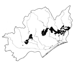 | Area: 1008 sq. km (5.0%) This extensive land system occurs on the hilly terrain with Ordovician, Devonian and Silurian sediments in the central and eastern parts of the East Victorian Uplands. The prominent ridge-and-ravine topography is characterised by moderately long, steep slopes, rock outcrop and active soil creep. Levees and alluvial flats similar to, though smaller than, those mapped in Walnut land system, occur occasionally along a few major streams, notably the Nicholson and Wonnangatta rivers. In most respects, Wonnangatta is a lower-relief version of Talbotville land system. It is similar in geology and topography to La Trobe land system but the climate is much drier. Steep slopes, slow-weathering sedimentary rocks and a climate which is inadequate to support vigorous and dense vegetation give rise to relatively rapid rates of natural erosion and slow soil formation. Thus shallow, stony, leached and acidic soils are characteristic. The structure of the topsoils tends to be weakly developed and subsoils are often apedal. Removal of the vegetation is likely to lead to severe sheet erosion. Shrubby open forest II predominates, with open forest III on protected sites and in some drainage corridors. | 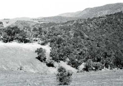 Hills with ridge-and-ravine topography and moderately long steep slopes north of Glenmaggie |
| CLIMATE Rainfall, mean (mm) Temperature, mean (°C) Seasonal growth limitations | Annual 700 - 1200; lowest January or February (40 - 80), highest October (100 - 150) Annual 8 - 12; lowest July (3 - 7), highest February (16 - 20) Temperature <10°C (av.): April - October Rainfall < potential evapotranspiration: December - February; occasional winter snow |
| GEOLOGY Age, lithology | Ordovician, Silurian and Devonian sandstones, siltstones and shales |
| PHYSIOGRAPHY Landscape Elevation range (m) Relative relief (m) Drainage pattern Drainage density (km/km2) | Steep hills with ridge-and-ravine topography 80 - 520 60 - 300 Dendritic 1.6 |
| PRESENT LAND USE | Mostly uncleared: hardwood forestry (minor timber products); apiculture; bush grazing of cattle (limited); small areas in Fairy Dell Scenic Reserve Minor proportion cleared: grazing of beef cattle and sheep |
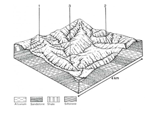 | 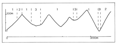 |
| LAND COMPONENT Percentage of land system Diagnostic features | 1 70 Exposed slopes, drier forest | 2 25 Protected slopes, moister forest | 3 5 Isolated narrow terraces in drainage corridors |
| PHYSIOGRAPHY Slope %, typical and (range) Slope shape | 25 - 30, (15 - 60) Straight | 25 - 30, (15 - 60) Straight | Variable, (0 - 30) Straight but uneven |
| SOIL | |||
| Parent material | Mudstone, siltstone, sandstone and shale | Alluvium | |
| Description | Dark clay loam to sandy loam grading into similarly or heavier textured brown or reddish brown subsoil. Shallow to very shallow, stony and acidic, but tending to be deeper in component 2 | Little differentiated greyish brown loamy sand to clay loam | |
| Classification | Lithosols; some Brown Earths and Red Podzolic Soils; Wiesenboden in small seepage areas Um4.13, Um5.51, Uc4.32, Uc1.44, Gn2.41, Gn4.34, Dr3.21, Dr3.61 | Alluvial Soils Uc1.43, Uc1.44, Um5.52 | |
| Surface texture | Clay loam to sandy loam | Loamy sand to clay loam | |
| Surface consistence | Slightly hard when dry, friable when moist | Varies with texture | |
| Depth (m) | Commonly <0.7, deeper pockets | >2.0 | |
| Nutrient status | Low | Low | |
| Available soil water capacity | Low to moderate | Low to moderate | |
| Perviousness to water | Moderate | Moderate to rapid | |
| Drainage | Good | Varies from somewhat poor to good | |
| Exposed stone (%) | 5 - 80 | 0 | |
| Sampled profile number | - | - | |
| NATIVE VEGETATION Structure of vegetation and characteristic species of dominant stratum (+ Predominant species) | Mainly shrubby open forest II, occasionally grassy open woodland: Mixed forests including — E. sieberi, E. macrorhyncha, E. goniocalyx, E. dives, E. globoidea (one of these usually predominant), E. polyanthemos, E. radiata, E. cypellocarpa, E. sideroxylon | Shrubby open forest III: E. muellerana+ or E. obliqua+ or, on upper slopes, E. sieberi+; E. cypellocarpa, E. globulus, E. sideroxylon commonly associated Occasionally closed forest II of Acmena smithii, climbers, ferns and epiphytes in drainage gullies | Mainly shrubby open forest II, III: E. bridgesiana+ and/or E. viminalis+, sometimes with E. radiata Rarely closed forest II: Acmena smithii, climbers, ferns and epiphytes |
Disturbance | Affected process and trend | Primary resultant deterioration | Causal activities | Primary off-site process | ||
Form | Susceptibility of components | Incidence within components | ||||
| Alteration of vegetation: — reduction in leaf area, rooting depth and/or perenniality — reduction in density of tree roots | Reduced transpiration, resulting in: a) increased deep percolation b) increased regolith wetness Decreased root-binding | Nutrient loss Soil creep Soil creep | Not determined 1; moderate 2; moderate – high 1; moderate 2; moderate - high | Not determined Common: on steep slopes Common: on steep slopes | Removal of trees Accelerated by major disturbance of native vegetation Accelerated by major disturbance of native vegetation | Increased movement of water to groundwater; increased base-flow of streams Increased sediment load Increased sediment load |
| Increased exposure of surface soil | Increased overland flow and soil detachment | Sheet and rill erosion | 1; moderate - high 2; moderate | Common | Clearing, logging, burning, overgrazing, road and dam building and other earth-moving activities, trafficking by stock. | Increased flash flows and sediment load. |
| Increased physical pressure on soil | Increased compaction With Reduced infiltration | Structure decline Sheet and rill erosion | 1; low 2; moderate 1; moderate - high 2; moderate | Uncommon Common | Increased trafficking, cultivation, overgrazing, export of organic matter As for sheet and rill erosion above | - Increased flash flows |
| Increased soil disruption | Increased soil break-up | Gully erosion Tunnel erosion Streambank erosion | 1,2; moderate 1; moderate on colluvial slopes 3; high | Common: locally severe Common Uncommon | As for sheet and rill erosion above As for sheet and rill erosion above As for sheet and rill erosion above | Increased sediment load and turbidity of streams. Increased sediment load and turbidity of streams. Increased sediment load and turbidity of streams. |
| Comments: Severe tunnel erosion occurs near Lake Glenmaggie | ||||||
© State of Victoria (Agriculture Victoria) 1996 - .

This work, Victorian Resources Online, is licensed under a Creative Commons Attribution 4.0 licence. You are free to re-use the work under that licence, on the condition that you credit the State of Victoria (Agriculture Victoria) as author, indicate if changes were made and comply with the other licence terms.
The licence does not apply to ‘branding’ or some ‘images or photographs’ that may be owned by third parties. We ask you to seek prior approval to use images using the VRO feedback form. Access to higher quality images can also be provided on request.
This page was last updated on .