
Valencia (Va)
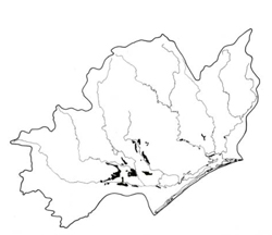 | Area: 158 sq. km (0.8%) Sea level began to fall after deposition of the earliest Pleistocene terrace materials. A temporary cessation of this fall led to the formation of a less-extensive, lower Pleistocene terrace, remnants of which can be found along the flanks of most of the major river valleys. Valencia and Yinnar land systems are mapped on this terrace. Valencia land system occurs in the main rain-shadow area of the Eastern lowlands on almost flat plains similar to those of Redgum 2 land system but with traces of fluviatile land forms still evident and with more variable and generally younger soils. Yinnar land system occurs further to the west in a more humid climate on terraces derived from Cretaceous sediments. Due to the stability of the very gently undulating to flat terrain, most soils have developed a duplex profile; further profile development has been limited by the clayey parent materials and rather poor drainage. The degree of mottling is variable but it usually occurs in the clay subsoils and frequently in the upper horizons as well. The topsoils are strongly to mildly acidic while the subsoils are mostly neutral to alkaline, probably caused by the presence of sodium. Erosion is generally minor but the sodic soils are susceptible to gully erosion along the margins of the terrace. The rain-shadow effect combined with poor internal drainage creates a low to moderate salinity hazard. The native vegetation, almost entirely cleared, appears to have been mainly a grassy open forest II dominated by E. tereticornis, with closed rushland in wetter back swamps. | 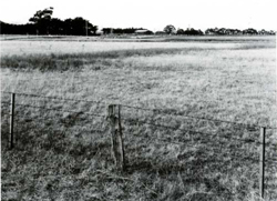 An almost flat plain with a poorly drained depression of a relict back-swamp |
| CLIMATE Rainfall, mean (mm) Temperature, mean (°C) Seasonal growth limitations |
Annual 500 - 800; lowest July (30 - 50), highest October (50 - 80) Annual 12 - 14; lowest July (8 - 10), highest February (19 - 21) Temperature <10°C (av.): June - August Rainfall < potential evapotranspiration: November – March |
| GEOLOGY Age, lithology |
Lower Pleistocene alluvium; gravels, sands, minor silts and clays |
| PHYSIOGRAPHY Landscape Elevation range (m) Relative relief (m) Drainage pattern Drainage density (km/km2) |
Almost flat alluvial plains of the second-highest terrace level 0 - 80 0 - 10 Dendritic 0.8 |
| PRESENT LAND USE |
|
| 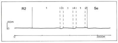 |
| LAND COMPONENT Percentage of land system Diagnostic features | 1 85 Broad almost flat plains | 2 5 Sloping terrace margins | 3 5 Drainage depressions of minor streams | 4 5 Relict back-swamps, poorly drained and possibly now functioning as drainage areas |
| PHYSIOGRAPHY Slope %, typical and (range) Slope shape | 1 - 2, (0 - 5) Straight | Variable, (0 - 10) Convex | <2 Concave | <1 Straight |
| SOIL | ||||
| Parent material | Mostly clay and silt but also some sand and gravel | |||
| Description | Very dark and sometimes mottled sandy loam to clay loam topsoil changing abruptly to yellowish brown clay subsoil with many grey and brown mottles | Limited observations — probably similar to component I but top- soil free of mottles and subsoil brown or reddish brown with few or no mottles | Limited observations — probably dark greyish brown loamy sand typical; possibly some black heavy soils | No observations — probably black heavy soil, mottled at depth; yellowish brown mottled duplex soils have been observed in similar situations in other land systems |
| Classification | Solodic Soils Dy3.42, Dy3.43, Dy3.33, Dy3.23 Db2.23, Dy3.32, Dy2.33 | Red Podzolic Soils Dr2.21 | Alluvial Soils Ucl.21, Ucl.23 | Wiesenboden, Humic Gleys - |
| Surface texture | Sandy loam to clay loam | Sandy loam to clay loam | Variable | Silty clay loam or heavier textures |
| Surface consistence | Friable to firm when moist | Friable to firm when moist | Soft to hard when dry | Firm when moist |
| Depth (m) | >2.0 | >2.0 | >2.0 | >2.0 |
| Nutrient status | Low to moderate | Low to moderate | Low to moderate | Moderate |
| Available soil water capacity | Low to moderate | Low to moderate | Low to moderate | Moderate |
| Perviousness to water | Slow | Slow | Slow to rapid | Very slow |
| Drainage | Poor to somewhat poor | Moderately good to good | Somewhat poor to good | Very poor to poor |
| Exposed stone (%) | 0 | 0 | 0 | 0 |
| Sampled profile number | 59, 66 | - | - | - |
| NATIVE VEGETATION Structure of vegetation and characteristic species of dominant stratum (+ Predominant species) | Grassy open forest II: E. tereticornis Closed rushland of Juncus spp. in wetter areas Clearing has made it difficult to determine if any other predominant or associated tree species | |||
Disturbance | Affected process and trend | Primary resultant deterioration | Causal activities | Primary off-site process | ||
Form | Susceptibility of components | Incidence within components | ||||
| Alteration of vegetation: — reduction in leaf area, rooting depth and/or perenniality | Reduced transpiration, resulting in: a) increased deep percolation b) raised watertable | Nutrient loss Salting | Not determined 2,3; moderate | Not determined Uncommon: isolated occurrences | Removal of trees Reduced plant water-use in the catchment | Increased movement of water to groundwater; increased base-flow of streams Raised watertable |
| Increased exposure of surface soil | Increased overland flow and soil detachment | Sheet and rill erosion | 2; low - moderate 3; low | Uncommon | Clearing, cultivation, overgrazing, road and dam building and other earth-moving activities, rabbit burrowing, trafficking by stock and vehicles. | Increased sedimentation and ponding in low-lying areas |
| Increased physical pressure on soil | Increased compaction With Reduced infiltration | Structure decline Sheet and rill erosion | 1,2; low 3,4; moderate 2; low - moderate 3; low | Uncommon Uncommon | Increased trafficking, overgrazing, export of organic matter As for sheet and rill erosion above | - Increased flash flows |
| Increased soil disruption | Increased soil break-up | Gully erosion | 2,3; low | Uncommon | As for sheet and rill erosion above | Increased sediment load. |
| Comments: Disturbances on adjoining land systems cause localised sheet, rill and gully erosion problems in the Valencia land system | ||||||
© State of Victoria (Agriculture Victoria) 1996 - .

This work, Victorian Resources Online, is licensed under a Creative Commons Attribution 4.0 licence. You are free to re-use the work under that licence, on the condition that you credit the State of Victoria (Agriculture Victoria) as author, indicate if changes were made and comply with the other licence terms.
The licence does not apply to ‘branding’ or some ‘images or photographs’ that may be owned by third parties. We ask you to seek prior approval to use images using the VRO feedback form. Access to higher quality images can also be provided on request.
This page was last updated on .