
Tyers (Ts)
 | Area: 5 sq. km (<0.1%) Tyers land system occurs on the Lake King side of the inner barrier where subsidence of the Pleistocene part of the barrier left only the tops of the old dune system protruding above lake level. Lacustrine and paludal in-filling has produced swampy flats between the old dune crests and these flats and remnant dunes are mapped in Tyers land system. The larger swamps are in Morass land system. The land forms are similar to those of Wollaston land system but their genesis is different. Also, the climate is more humid in Tyers land system. The sandy soils are acidic, infertile and droughty, with dark topsoils, bleached subsurfaces and iron and/or humus-enriched pans at depth. The dunes are susceptible to wind erosion upon disturbance. The ferny open woodland I of the dunes and the open woodland I of the flats are dominated mainly by E. botryoides and E. viminalis var. racemosa with Banksia spp. Salinas are bare of vegetation in the deepest parts and successively shallower areas towards the shore carry herbfield, rushland and a fringe of closed shrubland. | 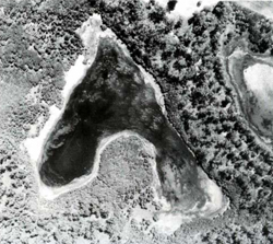 This large-scale aerial photograph of an area in the north-east of Raymond Island shows the swampy flats (shrubby vegetation, lower left) and the tops of old dunes (trees, upper right), representative of Tyers land system. |
| CLIMATE Rainfall, mean (mm) Temperature, mean (°C) Seasonal growth limitations |
Annual 600 - 900; lowest July or August (40 - 70), highest October (60 - 90) Annual 12 - 14; lowest July (9 - 10), highest February (19 - 20) Temperature <10°C (av.): No months Rainfall < potential evapotranspiration: December – March |
| GEOLOGY Age, lithology |
Pleistocene barrier deposits of sands; Holocene lacustrine and paludal fills of fine sands and probably some peat |
| PHYSIOGRAPHY Landscape Elevation range (m) Relative relief (m) Drainage pattern Drainage density (km/km2) |
Partly buried dune systems with intervening swampy in-filled flats 0 - 20 0 - 20 Nil 0 |
| PRESENT LAND USE |
|
 |  |
| LAND COMPONENT Percentage of land system Diagnostic features | 1 25 Dunes — the relict dune crests left above lake level after subsidence of the barrier | 2 25 Flats and plains — deposits in submerged interdune areas | 3 50 Drainage depressions, intermittently or permanently inundated |
| PHYSIOGRAPHY Slope %, typical and (range) Slope shape | 10 - 15, (3 - 30) Convex | <1, (0 - 2) Straight | <1, (0 - 2) Concave |
| SOIL | |||
| Parent material | Aeolian sand | Lacustrine and paludal sand | Aeolian sand |
| Description | No observations — probably acidic sand over coffee rock | No observations — probably acidic sand | No observations — probably black acidic sand over grey sand; may be saline in places |
| Classification | Podzols | - | Humic Gleys |
| Surface texture | Sand | Sand | Sand |
| Surface consistence | Loose or soft | Loose or soft | Soft |
| Depth (m) | >2.0 | >2.0 | >2.0 |
| Nutrient status | Very low | Very low | Very low |
| Available soil water capacity | Very low | Very low | Very low |
| Perviousness to water | Very rapid | Very rapid | Very rapid |
| Drainage | Somewhat excessive | Somewhat excessive | Very poor to somewhat poor |
| Exposed stone (%) | 0 | 0 | 0 |
| Sampled profile number | - | - | - |
| NATIVE VEGETATION Structure of vegetation and characteristic species of dominant stratum (+ Predominant species) | Limited data — probably ferny open woodland I: E. botryoides+ and/or E. viminalis var. racemosa+ with Banksia serrata or B. integrifolia (near lake shores) and Pteridium esculentum | Limited data — probably open woodland I: E. botryoides+ with B. integrifolia | Limited data — probably zonation of vegetation with, from margins inwards: Closed scrub of Melaleuca ericifolia Rushland of Juncus maritimus Herbfield of Salicornia spp. Centres often with free water |
|
|
|
|
| ||
|
|
| ||||
— reduction in leaf area, rooting depth and/or perenniality |
resulting in increased deep percolation and leaching |
|
|
|
|
|
|
|
|
2; low |
|
|
|
|
|
|
2,3; low |
|
|
|
|
|
|
2; low |
|
|
|
| Comments: Regeneration of vegetative cover on the dunes is usually slow because of low-fertility soils and exposure to wind | ||||||
© State of Victoria (Agriculture Victoria) 1996 - .

This work, Victorian Resources Online, is licensed under a Creative Commons Attribution 4.0 licence. You are free to re-use the work under that licence, on the condition that you credit the State of Victoria (Agriculture Victoria) as author, indicate if changes were made and comply with the other licence terms.
The licence does not apply to ‘branding’ or some ‘images or photographs’ that may be owned by third parties. We ask you to seek prior approval to use images using the VRO feedback form. Access to higher quality images can also be provided on request.
This page was last updated on .