
Thorpdale (Tp)
 | Area: 109 sq. km (0.6%) Areas of Tertiary basalt which have been subjected to extensive landslide activity, are mapped as the Thorpdale land system. The cause of the landslides is not clear but tectonic activity could have contributed. Most landslide debris has now been removed from the valleys by the streams but irregular debris deposits and landslide scars are characteristic of the slopes. Most occurrences are near Thorpdale where the volcanics have suffered considerable tectonic shock during uplift. Clearing of forests and irrigation from sub-basaltic aquifers has activated many slopes prone to landslides. The soils have developed on remnants of old, deep profiles which formed in a period with a warm, humid climate. They are very strongly weathered, leached and tend to fix phosphate in unavailable forms. Due to the high iron content in basalt and the weathering of most minerals to clay, the soil is a reddish brown, strongly-aggregated, granular or fine blocky clay. This fine, stable structure produces a high degree of friability and the soils are considered suitable for intensive cropping. The fine structure also promotes high permeability which results in lower rates of sheet erosion than those of other soils on similar gradients. The original vegetation, probably dominated by an open forest II or III of E. cypellocarpa, E. obliqua, E. radiata and E. viminalis, has been almost entirely cleared. | 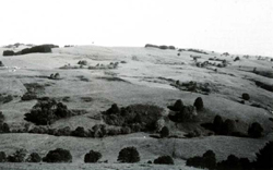 Numerous small landslips occur on the moderate slopes |
| CLIMATE Rainfall, mean (mm) Temperature, mean (°C) Seasonal growth limitations | Annual 800 - 1400; lowest January or February (40 - 70), highest August or October (90 - 120) Annual 12 - 14; lowest July (8 - 10), highest February (19 - 21) Temperature <10°C (av.): May - September Rainfall < potential evapotranspiration: December – February |
| GEOLOGY Age, lithology | Tertiary basalts (Older Volcanics); weathered |
| PHYSIOGRAPHY Landscape Elevation range (m) Relative relief (m) Drainage pattern Drainage density (km/km2) | Hills and slopes with extensive landslide activity 100 - 440 40 - 220 Dendritic 1.2 |
| PRESENT LAND USE | Cleared: grazing of dairy and beef cattle and fat lambs on improved pastures; some cropping, particularly potatoes; apiculture |
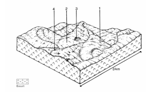 | 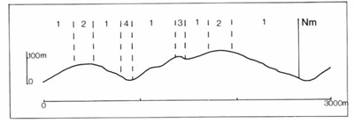 |
| LAND COMPONENT Percentage of land system Diagnostic features | 1 75 Steeper slopes with landslide scars and debris | 2 15 Gentle stable crest slopes | 3 2 Swamps impounded behind landslide debris | 4 8 Drainage depressions, often permanently wet due to seepage |
| PHYSIOGRAPHY Slope %, typical and (range) Slope shape | 20 - 25, (5 - 50) Straight or concave | 10, (0 - 15) Convex | <1, (0 - 2) Concave | <5, (0 - 10) Concave |
| SOIL | ||||
| Parent material | Weathered basalt with landslip deposits on steeper slopes | |||
| Description | Dark reddish brown to black loam to clay loam topsoil grading into friable reddish brown clay loam to silty clay subsoil. Mainly deep in component 1, moderately deep in component 2 | Black organic loam grading into mottled, sometimes stony grey clay at depth; inundated or with shallow water table | Locally derived alluvium Mottled dark greyish brown loam to clay loam topsoil over mottled lighter greyish brown similarly textured subsoil; shallow water table | |
| Classification | Krasnozems Gn3.11, Gn4.11, Um6.33 | Humic Gleys Um5.52, Gn3.92 | Humic Gleys Um6.12, Gn - | |
| Surface texture | Loam to clay loam | Loam | Loam to clay loam | |
| Surface consistence | Slightly hard when dry, friable when moist | Slightly plastic when wet | Friable when moist | |
| Depth (m) | >2.0 | 1.2 - 2.0 | >2.0 | >2.0 |
| Nutrient status | Low to moderate | Low to moderate | Moderate | Moderate |
| Available soil water capacity | Low to moderate | Low to moderate | High | Moderate to high |
| Perviousness to water | Rapid | Rapid | Rapid | Rapid |
| Drainage | Good | Good | Very poor | Very poor to poor |
| Exposed stone (%) | 0 | 0 | 0 | 0 |
| Sampled profile number | 30 | - | - | - |
| NATIVE VEGETATION Structure of vegetation and characteristic species of dominant stratum (+ Predominant species) | Open forest II, III: One or more of E. cypellocarpa, E. obliqua, E. radiata, E. viminalis usually predominant; E. ovata occasionally associated. (Vegetation is similar to Neerim land system, components 1, 2) | Probably open forest II, III: E. ovata, or sedgeland | Probably open forest II, III: E. ovata+ or E. viminalis+ | |
Original vegetation difficult to determine due to clearing | ||||
|
|
|
|
| ||
|
|
| ||||
— reduction in leaf area, rooting depth and/or perenniality
|
resulting in: a) increased deep percolation and leaching b) increased regolith wetness Decreased root-binding |
Nutrient loss Landslip and soil creep Landslip and soil creep |
1,2; moderate 1; moderate 2; low
2; low |
Not determined Common Common |
Removal of trees Accelerated by major disturbance of native vegetation Accelerated by major disturbance of native vegetation |
Increased movement of water to groundwater; increased base-flow of streams Increased sediment load Increased sediment load |
|
|
|
|
|
|
|
|
With Reduced infiltration |
Sheet and rill erosion |
3,4; high 1; low - moderate |
Common: particularly on cleared, steep slopes |
As for sheet and rill erosion above |
Increased flash flows |
|
|
|
2; low |
|
|
|
| ||||||
© State of Victoria (Agriculture Victoria) 1996 - .

This work, Victorian Resources Online, is licensed under a Creative Commons Attribution 4.0 licence. You are free to re-use the work under that licence, on the condition that you credit the State of Victoria (Agriculture Victoria) as author, indicate if changes were made and comply with the other licence terms.
The licence does not apply to ‘branding’ or some ‘images or photographs’ that may be owned by third parties. We ask you to seek prior approval to use images using the VRO feedback form. Access to higher quality images can also be provided on request.
This page was last updated on .