
Thomson (Th)
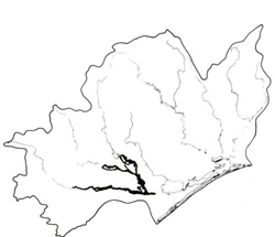 | Area: 175 sq. km (0.9%) The lowest levels of the modern flood plains in the main rain-shadow area of the Eastern lowlands, on which clayey alluvium predominates is mapped as Thomson land system. Major river channels, small levees, numerous oxbows, billabongs, swamps and clay plains are included. Stream courses are highly sinuous and meander cutoffs are common. These lowest level flood plains are relatively narrow but they carry the bulk of the flood waters. Traralgon land system also occurs on the lowest levels of the modern flood plains but it is in the more humid parts of the Western lowlands, mostly along tributaries of the major rivers. There has been little soil development on the youthful, mostly clayey and poorly drained alluvia, and most variation in these areas relates to texture and drainage. Some accumulation of organic matter has occurred, particularly in depressions and here organic loams may be found, but commonly fresh alluvium covers darker-coloured, former topsoil. On the well-drained levees textures tend to be lighter and the upper horizons tend to have weak or moderate subangular blocky structures. | 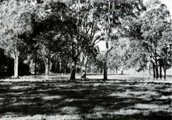 A swampy depression on the modern alluvial flood plain of the Thomson River. |
| Erosion hazards are minimal but many areas are subject to frequent sediment deposition. Clearing of vegetation has facilitated flood flow and increased flooding problems downstream. The native vegetation, probably mainly open forest II of E. tereticornis with Melaleuca ericifolia closed scrub on wetter sites, has been almost completely removed. | ||
| CLIMATE Rainfall, mean (mm) Temperature, mean (°C) Seasonal growth limitations | Annual 500 - 800; lowest July (30 - 50), highest October (50 - 80) Annual 12 - 14; lowest July (8 - 10), highest February (19 - 21) Temperature <10°C (av.): June - August Rainfall < potential evapotranspiration: November – March |
| GEOLOGY Age, lithology | Holocene alluvium |
| PHYSIOGRAPHY Landscape Elevation range (m) Relative relief (m) Drainage pattern Drainage density (km/km2) | Plains with abundant fluviatile forms on the lowest alluvial terrace 20 - 80 0 - 5 Meander channel 1.8 |
| PRESENT LAND USE | Mostly cleared: grazing of beef and dairy cattle on improved, often irrigated, pastures; cropping (limited); apiculture; recreation — caravaning, fishing and shooting |
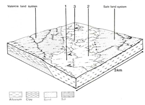 | 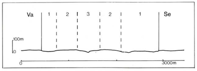 |
| LAND COMPONENT Percentage Diagnostic | 1 45 Plains with many relict channels, oxbows and low-lying areas | 2 35 Plains relatively free of channels | 3 20 Modern levees, including river channels |
| PHYSIOGRAPHY Slope %, typical and (range) Slope shape | 2, (0 - 5) Straight but some concave | 1, (0 - 2) Straight | 1, (0 - 2) Variable |
| SOIL | |||
| Parent material | Mostly fine-textured alluvium | Medium-textured alluvium | |
| Description | Soil varies with site drainage — better drained areas with dark brown clay loam to clay; sites with impeded or very poor drainage with dark greyish brown or dark grey clay loam to clay, often mottled throughout; evidence of alluvial stratification common at depth | Levee soils of dark greyish brown loamy sand to sandy clay loam topsoil merging into dark brown or dark yellowish textured subsoil, often stratified | |
| Classification | Wiesenboden, Humic Gleys, Alluvial Soils Dd2.11, Gn2.81, Uf6.11, Um6.21 | Alluvial Soils/Brown Earths, Prairie Soil Um6.21, Um6.23 | |
| Surface texture | Mostly clay loam, can be much sandier | Loamy sand to sandy clay loam | |
| Surface consistence | Friable to firm when moist, often hard when dry | Very friable to firm when moist | |
| Depth (m) | >2.0 | >2.0 | |
| Nutrient status | Moderate | Moderate to high | |
| Available soil water capacity | Moderate to high | Moderate | |
| Perviousness to water | Slow to moderate | Moderate to rapid | |
| Drainage | Mostly poor to somewhat poor, some very poor | Good | |
| Exposed stone (%) | 0 | 0 | |
| Sampled profile number | - | 23 | |
| NATIVE VEGETATION Structure of vegetation and characteristic species of dominant stratum (+ Predominant species) | Open forest I, II, often shrubby: Mainly E. tereticornis+, E. polyanthemos+ (drier sites); E. ovata+ and E. viminalis+ (moister sites) Closed scrub of Melaleuca ericifolia+ in wet areas | Grassy open forest II: E. tereticornis+ with or without E. polyanthemos | 0pen forest II, III, often shrubby or layered: E. tereticornis+ |
|
|
|
|
| ||
|
|
| ||||
— reduction in leaf area, rooting depth and/or perenniality |
resulting in raised watertable |
|
|
|
|
|
|
|
|
2; low - moderate 3; moderate |
|
|
|
|
With Reduced infiltration |
Scour erosion |
3; low – moderate 1; low 2; low - moderate 3; moderate |
Uncommon |
As for scour erosion above |
Increased run-on and ponding in low-lying areas |
|
Increased loosening of sand |
Scour erosion |
1; low 2; low - moderate 3; moderate |
Uncommon |
As for scour erosion above |
Increased sediment load |
| ||||||
© State of Victoria (Agriculture Victoria) 1996 - .

This work, Victorian Resources Online, is licensed under a Creative Commons Attribution 4.0 licence. You are free to re-use the work under that licence, on the condition that you credit the State of Victoria (Agriculture Victoria) as author, indicate if changes were made and comply with the other licence terms.
The licence does not apply to ‘branding’ or some ‘images or photographs’ that may be owned by third parties. We ask you to seek prior approval to use images using the VRO feedback form. Access to higher quality images can also be provided on request.
This page was last updated on .