
Traralgon (Tg)
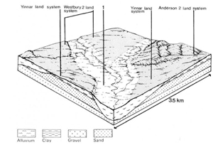
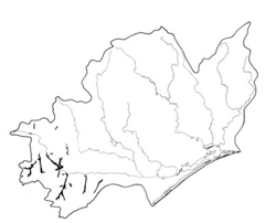 | Area: 96 sq. km (0.5%) Drainage depressions along tributaries of the La Trobe River, in which fine-textured alluvium predominates, have been mapped as the Traralgon land system. Variability in stream hydrology and in the nature and history of the catchments has affected the characteristics of these areas. Most have narrow, alluvial plains, often poorly drained, and more or less sinuous, central stream channels. In places there is a pattern of slightly depressed, abandoned stream channels. Some artificial channels have been dug to promote drainage. Post-settlement increments of alluvium are common. Thomson land system also occurs on the lowest, clayey terraces but Traralgon differs from it in occurring along smaller streams in the more humid parts of the Western lowlands. Flood regime and native vegetation also differ. | 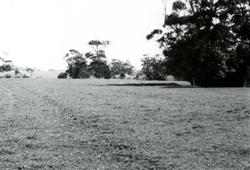 A broad, alluvial terrace adjacent to the incised system |
| Impeded soil drainage and relatively youthful parent materials have resulted in little soil development beyond the accumulation of organic matter in the topsoil, the formation of mottles and the development of weak to moderate blocky structure below the topsoil. Minor variations in soil features are often traceable to differences in soils of the source catchments. Erosion hazards are minor but human activities in the catchments may lead to large deposits of sediments on the drainage depressions. The original vegetation, probably open forest II or III, may often have been shrubby. It is now largely removed. | ||
| CLIMATE Rainfall mean (mm) Temperature, mean (°C) Seasonal growth limitations |
Annual 700 - 1200; lowest January (40 - 70), highest October (70 - 100) Annual 12 - 14; lowest July (8 - 10), highest February (19 - 21) Temperature <10°C (av.): June - August Rainfall < potential evapotranspiration: November – March |
| GEOLOGY Age, lithology |
Holocene fluviatile deposits, mostly clayey |
| PHYSIOGRAPHY Landscape Elevation range (m) Relative relief (m) Drainage pattern Drainage density (km/km2) |
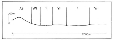
Narrow poorly drained alluvial plains with small meandering streams 20 - 500 0 - 5 Channel with closely-spaced meanders 5.0 |
| PRESENT LAND USE |
|
 |  |
| LAND COMPONENT Percentage of land system Diagnostic features | 1 100 Drainage depressions and minor terraces |
| PHYSIOGRAPHY Slope %, typical and (range) Slope shape | <2, (0 - 10) Straight |
| SOIL | |
| Parent material | Mostly clayey alluvium |
| Description | Mainly very dark greyish brown silty loam to clay loam topsoil, in places quite organic, commonly with fine yellowish brown mottles, grading into greyish brown or grey strongly mottled clay loam to clay subsoil with blocky structure; profiles usually mildly to moderately acidic throughout; stratification common. Small areas of better drained whole-coloured soils. |
| Classification | Wiesenboden; some Humic Gleys; Brown Earths in occasional well drained sites Gn4.51, Gn4.52, Gn4.41, Gn3.41, Gn2.81, Uml.44, Uf6.12, Dd2.21 |
| Surface texture | Silty loam to clay loam |
| Surface consistence | Friable to firm when moist |
| Depth (m) | >2.0 |
| Nutrient status | Moderate to high |
| Available soil water capacity | Moderate |
| Perviousness to water | Slow |
| Drainage | Mostly poor to somewhat poor; in places moderately good to good |
| Exposed stone (%) | 0 |
| Sampled profile number | - |
| NATIVE VEGETATION Structure of vegetation and characteristic species of dominant stratum (+ Predominant species) | Open forest II, III, often shrubby: Mainly E. ovata+; better drained sites with E. obliqua+ and E. radiata+ or E. viminalis+ |
|
|
|
|
| ||
|
|
| ||||
— reduction in leaf area, rooting depth and/or perenniality |
resulting in raised watertable |
|
|
|
|
|
|
|
|
|
|
|
|
|
|
|
|
|
|
|
|
|
|
|
|
|
|
| ||||||
© State of Victoria (Agriculture Victoria) 1996 - .

This work, Victorian Resources Online, is licensed under a Creative Commons Attribution 4.0 licence. You are free to re-use the work under that licence, on the condition that you credit the State of Victoria (Agriculture Victoria) as author, indicate if changes were made and comply with the other licence terms.
The licence does not apply to ‘branding’ or some ‘images or photographs’ that may be owned by third parties. We ask you to seek prior approval to use images using the VRO feedback form. Access to higher quality images can also be provided on request.
This page was last updated on .