
Tambo (Tb)
 | Area: 400 sq. km (2.0%) Low hills and undulating terrain occur on Ordovician sediments at low elevations close to the southern margin of the East Victorian Uplands and along some of the major river valleys. These areas are mapped as the Tambo land system. Some ridge crests are rounded but most slopes are short and moderately steep. Occurring in scattered localities, this land system is ecologically diverse. The area is topographically similar to the Avon land system on Carboniferous sediments. Shallow soils, with rock fragments common, particularly in the lower horizons, have formed on the moderate and gentle slopes. Soil depth appears to be limited by rock strata that is resistant to weathering. The soils typically show increasing clay content with depth, the increase appearing to be more gradual than abrupt. The reaction is moderately to strongly acidic, often tending to neutrality at depth. Open forest II predominates, with open forest III on some protected slopes. | 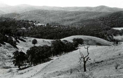 The low relief on the rounded hill is apparent when compared with the ridge (right background) of Talbotville land system. |
| CLIMATE Rainfall, mean (mm) Temperature, mean (°C) Seasonal growth limitations |
Annual 700 - 1200; lowest January or February (40 - 80), highest October (100 - 150) Annual 12 - 14; lowest July (8 - 10), highest February (19 - 21) Temperature <10°C (av.): May - September Rainfall < potential evapotranspiration: November – March |
| GEOLOGY Age, lithology |
Mostly Ordovician sandstones, mudstones and shales |
| PHYSIOGRAPHY Landscape Elevation range (m) Relative relief (m) Drainage pattern Drainage density (km/km2) |
Rounded low hills and undulating terrain 40 - 540 40 - 160 Dendritic 0.5 |
| PRESENT LAND USE |
Cleared areas: grazing of cattle on improved pastures |
 |  |
| LAND COMPONENT Percentage of land system Diagnostic features | 1 45 Steeper slopes and sharp or sub-rounded peaks | 2 30 Gentle lower slopes | 3 5 Broad rounded crests | 4 10 Protected slopes | 5 5 Minor drainage depressions | 6 5 Terraces in major drainage corridors |
| PHYSIOGRAPHY Slope %, typical and (range) Slope shape | 20 - 30, (10 - 40) Straight | 10 - 15, (5 - 20) Concave | 5, (0 - 10) Convex | 20 - 30, (10 - 40) Concave | <2, (0 - 5) Concave | <5, (0 - 10) Straight but uneven |
| SOIL | ||||||
| Parent material | Sandstone, mudstone and shale | Colluvium and local alluvium | Alluvium | |||
| Description | Very dark greyish brown loamy sand to loam topsoil; gradual or abrupt change to yellowish brown or reddish brown, sometimes mottled, clay subsoil, usually with blocky structure. Commonly stony, sometimes shallow, probably depending on hardness of underlying rock and slope | Variable; sand to clayey texture; greyish brown, often mottled; may be stony | Limited observation — undifferentiated brown sand | |||
| Classification | Yellow Podzolic Soils; some Red Podzolic Soils and Brown Earths; rarely Lithosols Gn3.21, Gn3.54, Gn2.41, Gn2.44, Gn3.11 Dy3.21, Dy3.41 | Humic Gleys, Siliceous Sands Gn3.91, Uc1.23 | Alluvial Soils Uc1.23 | |||
| Surface texture | Loamy sand to loam | Variable | - | |||
| Surface consistence | Variable; soft to hard when dry | Variable | - | |||
| Depth (m) | 0.9 - 1.5; <0.9 where hard bedrock and/or steeper slopes | >2.0 | >2.0 | |||
| Nutrient status | Low to moderate | Low to moderate | Low to moderate | |||
| Available soil water capacity | Moderate | Very variable | Very variable | |||
| Perviousness to water | Mostly slow | Very variable | Very variable | |||
| Drainage | Good | Moderately good to good | Somewhat poor to good | Good | Mostly poor | Mostly good |
| Exposed stone (%) | Generally 0, but up to 20 where soil shallow | 0 | 0 | |||
| Sampled profile number | - | - | - | |||
| NATIVE VEGETATION Structure of vegetation and characteristic species of dominant stratum (+ Predominant species) | Open forest II: | Shrubby open forest I and II: | Open forest II, III often shrubby: | Mostly open forest II: E. ovata+, E. bridgesiana or E. polyanthemos, some times with E. radiata Rarely closed forest II: Acmena smithii, Pittosporum undulatum, climbers, ferns and epiphytes | Limited data — open forest II: E. viminalis+ | |
E. globoidea usually predominant, occasionally E. polyanthemos or E. consideniana (in poorer drained sites); E. cypellocarpa or E. sideroxylon sometimes associated | E. cypellocarpa+ and/or E. obliqua+; E. radiata or E. globoidea often associated | |||||
|
|
|
|
| ||
|
|
| ||||
— reduction in leaf area, rooting depth and/or perenniality |
resulting in increased deep percolation |
|
|
|
|
|
|
|
|
4; low |
|
|
|
|
With Reduced infiltration |
Sheet and rill erosion |
5,6; low – moderate 1,2,3; moderate 4; low |
Uncommon |
As for sheet and rill erosion above |
Increased flash flows |
|
|
|
5; moderate 4,6; low |
|
|
|
| ||||||
© State of Victoria (Agriculture Victoria) 1996 - .

This work, Victorian Resources Online, is licensed under a Creative Commons Attribution 4.0 licence. You are free to re-use the work under that licence, on the condition that you credit the State of Victoria (Agriculture Victoria) as author, indicate if changes were made and comply with the other licence terms.
The licence does not apply to ‘branding’ or some ‘images or photographs’ that may be owned by third parties. We ask you to seek prior approval to use images using the VRO feedback form. Access to higher quality images can also be provided on request.
This page was last updated on .