
Stockdale (St)
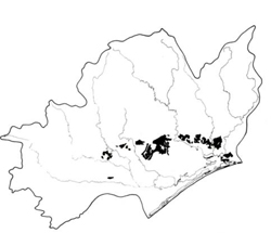 | Area: 368 sq. km (1.8%) Stockdale land system occurs mainly on dissected Tertiary fan deposits close to the East Victorian Uplands. Dissection is deeper than usual for the Eastern lowlands due to high elevation, the steep slopes of the deposits and the coarse unconsolidated materials. Rounded hills occur with moderately steep slopes and a broad drainage pattern. Small landslides are very common in Stockdale land system, and larger examples have been noted on steeper slopes. Geology and topography are similar to Anderson 1 and 2 and Salt Creek land systems, but Stockdale land system is mapped on the sandier deposits. As sandy materials may be difficult to detect on air photographs, the boundaries must be considered as somewhat tentative. |  Gentle to moderate slope typical of Stockdale land system; bracken indicates the sandy nature of the soils |
| Although the deposits are mainly sands, silty and clayey beds have been observed. The presence of a drainage system and landslides also point to the existence of less permeable strata at depth. Because of these strata and their effects on hydrological processes, Stockdale has been placed in a different geomorphological province from other land systems of sandy deposits. The sediments were weathered prior to deposition in the Tertiary and further weathering and leaching have occurred since. The soils are, therefore, mostly low in nutrients. Deep, moderately to strongly acidic Podzols and Earthy Sands predominate. Podzols also occur over clayey substrata where the clays are deeper than about 1.2 m. Where the clays are close to the surface, the soils are duplex with blocky subsoils and an acidic reaction. The vegetation is mainly open forest II in which the most common dominant species is E. globoidea. Drainage depressions carry open forest I or II, mostly shrubby, or occasionally closed forest II in more protected areas. | ||
| CLIMATE Rainfall, mean (mm) Temperature, mean (°C) Seasonal growth limitations |
Annual 500 - 800; lowest July (30 - 50), highest October (50 - 80) Annual 12 - 14; lowest July (8 - 10), highest February (19 - 21) Temperature <10°C (av.): June - August Rainfall < potential evapotranspiration: November – March |
| GEOLOGY Age, lithology |
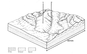
Tertiary fan and colluvial apron deposits of unconsolidated gravels, sands, minor silts and clays (Sale Group) |
| PHYSIOGRAPHY Landscape Elevation range (m) Relative relief (m) Drainage pattern Drainage density (km/km2) |
Broadly dissected fans; rounded hills with moderate slopes and relief 0 - 210 20 - 100 Dendritic 0.3 |
| PRESENT LAND USE |
Minor proportion cleared: softwood plantations; grazing of sheep and beef cattle |
 | 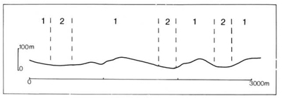 |
| LAND COMPONENT Percentage of land system Diagnostic features | 1 85 Gentle to moderate slopes and broad crests with scattered steep short slopes | 2 15 Unchannelled sandy drainage depressions |
| PHYSIOGRAPHY Slope %, typical and (range) Slope shape | 6 - 10, (0 - 30) Variable and uneven | <2, (0 - 5) Straight or concave |
| SOIL | ||
| Parent material | Sand, silt, gravel and clay, in places covered by windblown and colluvial sand. Substrata variable over short distances | Alluvium, often sandy |
| Description | Variable due to variation in parent material; dark grey to black loamy sand to coarse sand topsoil grading through lighter grey to yellowish brown sand, sometimes with coffee rock hard pan. Also dark grey to black loamy sand to sandy loam over mottled yellowish brown clay subsoil | Limited observations — probably dark greyish brown light-textured topsoil, sometimes mottled, over stratified variously textured mottled subsoil |
| Classification | Podzols, Earthy Sands, Yellow Podzolic Soils, Siliceous Sands Uc2.21, Uc3.21, Uc4.32, Uc3.31, Uc4.11, Uc4.22, Uc4.31, Uc5.23, Dy3.21 Dy3.31, Dy5.41 | Alluvial Soils, Wiesenboden Uc5.23, Dy5.61 |
| Surface texture | Coarse sand to sandy loam | Probably sand to sandy loam |
| Surface consistence | Very variable | Probably slightly hard when dry |
| Depth (m) | >2.0 | >2.0 |
| Nutrient status | Low | Low |
| Available soil water capacity | Low | Low |
| Perviousness to water | Moderate to rapid | Moderate |
| Drainage | Good (Podzols, Earthy Sands, Siliceous Sands); somewhat poor (Yellow Podzolic Soils) | Very poor to poor |
| Exposed stone (%) | 0 | 0 |
| Sampled profile number | 8,9,52 | - |
| NATIVE VEGETATION Structure of vegetation and characteristic species of dominant stratum (+ Predominant species) | Open forest II: Mainly mixed forests with composition and predominant species variable. E. globoidea most commonly predominant; less common predominants include E. bosistoana, E. tereticornis, E. muellerana, E. sieberi and, near the coast, E. botryoides. E. sideroxylon, E. polyanthemos or E. cypellocarpa often associated | Mostly shrubby open forest I or II: E. bridgesiana or E. ovata usually predominant; E. viminalis often associated Occasional small areas of closed forest II: Acmena smithii, climbers, ferns and epiphytes |
|
|
|
|
| ||
|
|
| ||||
— reduction in leaf area, rooting depth and/or perenniality |
resulting in: a) increased deep percolation and leaching b) increased regolith wetness |
Nutrient loss Landslip |
1; high 1; moderate |
Not determined Common |
Removal of trees Accelerated by major disturbance of the native vegetation |
Increased movement of water to groundwater; increased base-flow of streams Increased sediment load |
|
Increased wind velocity over soil and increased detachment of sand |
Wind erosion |
1; low |
Uncommon: local occurrences on exposed, cleared sites |
|
Encroachment by sand |
|
With Reduced infiltration |
Sheet and rill erosion |
1; moderate |
Uncommon |
As for sheet and rill erosion above |
Increased flash flows |
|
Increased loosening of sand |
Wind erosion |
1; low |
Uncommon (as for wind erosion above) |
As for sheet and rill erosion above |
Encroachment by sand |
| Comments: Most landslips appear to pre-date settlement size of slip correlated to steepness of slope. Some subsoils are very dispersive and road-side drains gully easily. | ||||||
© State of Victoria (Agriculture Victoria) 1996 - .

This work, Victorian Resources Online, is licensed under a Creative Commons Attribution 4.0 licence. You are free to re-use the work under that licence, on the condition that you credit the State of Victoria (Agriculture Victoria) as author, indicate if changes were made and comply with the other licence terms.
The licence does not apply to ‘branding’ or some ‘images or photographs’ that may be owned by third parties. We ask you to seek prior approval to use images using the VRO feedback form. Access to higher quality images can also be provided on request.
This page was last updated on .