
Salt Creek (SC)
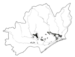 | Area: 194 sq. km (1.0%) Salt Creek land system occurs in the main rain-shadow area of the lowlands to the east of Lake Glenmaggie, on hills and Eastern steep slopes cut into Tertiary and Pleistocene deposits. It is usually found along incised drainage lines but it also includes the dissected coastal edge of the Pleistocene plains mapped in Redgum 1 land system. The rounded hills with moderate slopes and a broad dissection pattern are similar to those in Anderson 1 and 2 and Stockdale land systems. However the vegetation of Anderson 1 or 2 does not contain redgums and in Stockdale the parent materials are sandier. Clayey parent materials and duplex soils dominate and significant amounts of quartz gravels may occur in the upper horizons. Due to low rainfall and the lack of leaching the subsoils are commonly neutral to slightly alkaline at depth and may be susceptible to gullying. Some areas of deep sands occur. The native vegetation, now almost entirely removed, was a grassy open forest II of E. tereticornis, sometimes accompanied by E. globoidea on areas of higher elevation, higher rainfall or better drainage. | 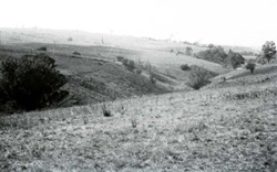 Low rounded spurs produced by dissection of the Tertiary plateau |
| CLIMATE Rainfall, mean (mm) Temperature, mean (°C) Seasonal growth limitations |
Annual 500 - 800; lowest July (30 - 50), highest October (50 - 80) Annual 12 - 14; lowest July (8 - 10), highest February (19 - 21) Temperature <10°C (av.): June - August Rainfall < potential evapotranspiration: November – March |
| GEOLOGY Age, lithology |
Mainly Tertiary but some Pleistocene colluvial and alluvial deposits of gravels, sands, silts, clays; minor marine limestones (Seaspray Group) |
| PHYSIOGRAPHY Landscape Elevation range (m) Relative relief (m) Drainage pattern Drainage density (km/km2) |
Hilly terrain or short relatively steep marginal slopes 0 - 120 10 - 60 Dendritic 1.7 |
| PRESENT LAND USE |
|
 |  |
| LAND COMPONENT Percentage of land system Diagnostic features | 1 50 Short, steep slopes, often gravelly; minor cliffs | 2 20 Gentle slopes | 3 10 Drainage depressions | 4 10 Steep slopes on limestone in lower parts of deep valleys | \ - Fans da10 dudror1 |
| PHYSIOGRAPHY Slope %, typical and (range) Slope shape | 10 - 20, (10 - 50) Straight | 3 - 5, (1 - 10) Concave | 2, (0 - 5) Straight to concave | 12 - 18, (10 - 40) Straight or convex | 10 - j Conca,e21 |
| SOIL | |||||
| Parent material | Gravel, sand, silt and clay | Alluvium | Limestone | Variable colluvium | |
| Description | Dark greyish brown loamy sand to sandy clay loam topsoil, often gravelly; abrupt change to yellowish brown or reddish brown, blocky structured clay subsoil | Limited observations — pr over mottled greyish loam brown clay | Dark reddish brown clay loam to clay over red blocky alkaline clay; may be gravelly | Variable: includes deep pale coloured sands and mottled yellowish brown duplex soils | |
| Classification | Soloths, Solodic Soils Dy2.21, Dy2.42, Dy3.21, Dy3.41, Dr3.21 | Humic Gleys | Terra Rossa Soils | Earthy Sands, Solodic Soils Uc4.11, Dy3.22 | |
| Surface texture | Loamy sand to sandy clay loam | Probably silty loam to silty clay loam | Clay loam to clay | Variable | |
| Surface consistence | Mostly slightly hard when dry, but hard for heavier soils | - | Friable to firm when moist | Variable | |
| Depth (m) | >2.0 | >2.0 | 0.3 - 1.0 | >2.0 | |
| Nutrient status | Low to moderate | Low | Moderate | Variable | |
| Available soil water capacity | Low | High | Moderate | Variable | |
| Perviousness to water | Slow | Rapid | Moderate | Variable | |
| Drainage | Mostly moderately good | Mostly poor | Good | Variable | |
| Exposed stone (%) | 0 | 0 | 0 | 0 | |
| Sampled profile number | - | 62, 63 | - | 13 | - |
| NATIVE VEGETATION Structure of vegetation and characteristic species of dominant stratum (+ Predominant species) | Grassy open forest II: Mostly E. tereticornis+, occasionally E. globoidea+ (better drained sites) or E. polyanthemos+; E. cypellocarpa and E. bridgesiana localities associated in some | Grassy open forest II: Limited data — probably E. tereticornis+ Clearing has made it difficult to determine if any other tree species predominant or associated | |||
|
|
|
|
| ||
|
|
| ||||
— reduction in leaf area, rooting depth and/or perenniality |
resulting in increased deep percolation and leaching |
|
|
|
|
|
|
|
|
2,5; moderate 3; low 4; moderate - high |
land |
|
|
|
With Reduced infiltration |
Sheet and rill erosion |
3; high 4; moderate 1; high 2,5; moderate 3; low 4; moderate - high |
Common: on cleared land |
As for sheet and rill erosion above |
Increased flash flows |
|
|
|
2; moderate 3,4,5; low |
|
|
|
| ||||||
© State of Victoria (Agriculture Victoria) 1996 - .

This work, Victorian Resources Online, is licensed under a Creative Commons Attribution 4.0 licence. You are free to re-use the work under that licence, on the condition that you credit the State of Victoria (Agriculture Victoria) as author, indicate if changes were made and comply with the other licence terms.
The licence does not apply to ‘branding’ or some ‘images or photographs’ that may be owned by third parties. We ask you to seek prior approval to use images using the VRO feedback form. Access to higher quality images can also be provided on request.
This page was last updated on .