
Rotamah (Rh)
 | Area: 14 sq. km (0.1%) Rotamah land system occurs near Lakes Entrance on Holocene sands added to the inner barrier; these sands are adjacent to the modern coastal foredune system. As with the rest of the inner barrier which is of older sands, an uneven sand sheet has formed from a close sequence of beach-ridge deposits. There is also a slightly different vegetation type, probably resulting from the slightly more humid climate. Although the marine sands originally contained shell fragments, the carbonate has been removed by leaching. The sands are now acidic, of very low fertility, droughty and susceptible to wind erosion. The vegetation is a ferny open woodland I dominated mainly by E. botryoides, with Banksia spp. and Pteridium esculentum. | 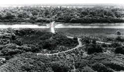 An aerial photograph showing the causeway to Rotamah Island with a typical woodland of Eucalyptus hotryoides and Banksia species in the background |
| CLIMATE Rainfall, mean (mm) Temperature, mean (°C) Seasonal growth limitations |
Annual 600 - 900; lowest July or August (40 - 70), highest October (60 - 90) Annual 12 - 14; lowest July (9 - 10), highest February (19 - 20) Temperature <10°C (av.): No months Rainfall < potential evapotranspiration: December – March |
| GEOLOGY Age, lithology |
Holocene barrier and coastal foredune sand deposits |
| PHYSIOGRAPHY Landscape Elevation range (m) Relative relief (m) Drainage pattern Drainage density (km/km2) |
Uneven sand sheets formed from a close sequence of beach ridge deposits 0 - 20 0 - 5 Nil 0 |
| PRESENT LAND USE |
|
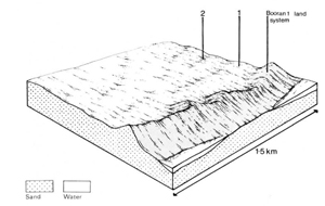 |  |
| LAND COMPONENT Percentage of land system Diagnostic features | 1 90 Ridges | 2 10 Swales |
| PHYSIOGRAPHY Slope %, typical and (range) Slope shape | 4, (2 - 8) Mainly convex | <1, (0 - 2) Concave or straight |
| SOIL | ||
| Parent material | Sand of marine origin | |
| Description | No observations — probably leached acidic sand, pale or whitish in the subsurface, generally over coffee rock or bright yellowish brown sand; light coloured sand below | |
| Classification | Probably Podzols; Uc4.3-, Uc2.3-, Uc4.2-, Uc2.2- Siliceous Sands; Uc1.21 | |
| Surface texture | Sand | |
| Surface consistence | Loose or soft | |
| Depth (m) | >2.0 | |
| Nutrient status | Very low | |
| Available soil water capacity | Very low | |
| Perviousness to water | Very rapid | |
| Drainage | Somewhat excessive | |
| Exposed stone (%) | 0 | |
| Sampled profile number | - | |
| NATIVE VEGETATION Structure of vegetation and characteristic species of dominant stratum (+ Predominant species) | Ferny open woodland I: Variable composition — species including E. botryoides, E. viminalis var. racemosa, Banksia serrata, B. integrifolia (near lake shores) and Pteridium esculentum | |
|
|
|
|
| ||
|
|
| ||||
— reduction in leaf area, rooting depth and/or perenniality |
|
|
|
|
|
|
|
|
Wave erosion |
2; moderate 2; moderate |
Uncommon |
Removal of protective reeds along shore line |
Turbidity of lake waters |
|
|
|
2; low - moderate |
|
|
|
|
|
Wave erosion |
2; moderate 2; moderate |
Uncommon |
Above As for wave erosion above |
Turbidity of lake waters |
| ||||||
© State of Victoria (Agriculture Victoria) 1996 - .

This work, Victorian Resources Online, is licensed under a Creative Commons Attribution 4.0 licence. You are free to re-use the work under that licence, on the condition that you credit the State of Victoria (Agriculture Victoria) as author, indicate if changes were made and comply with the other licence terms.
The licence does not apply to ‘branding’ or some ‘images or photographs’ that may be owned by third parties. We ask you to seek prior approval to use images using the VRO feedback form. Access to higher quality images can also be provided on request.
This page was last updated on .