
Redgum 2 (R2)
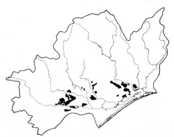 | Area: 331 sq. km (1.6%) Redgum 2 also occurs on the earlier Pleistocene terraces and more distal parts of the Tertiary flood plain deposits, but differs from Redgum 1 land system in that it has suffered very little dissection. The original land surface is usually unchannelled and forms almost flat plains, commonly with low gilgai micro-relief. Well-developed, duplex soils have formed on the flat terrain. Varying amounts of rounded gravels can occur within the profile. Erosion hazards are slight, but extensive clearing may aggravate waterlogging, particularly during winter and spring. The Redgum 2 land system is judged to have a moderate salinity hazard. The native vegetation, mainly an E. tereticornis grassy open forest II, is now mostly cleared. |  Flat plain with reeds growing in the wetter depressions. The dead trees are indicative of the decline in the Eucalypt tereticornis (forest red gum) woodland which once covered most of this plain |
| CLIMATE Rainfall, mean (mm) Temperature, mean (°C) Seasonal growth limitations |
Annual 500 - 800; lowest July or August (30 - 50), highest October (50 - 80) Annual 12 - 14; lowest July (8 - 10), highest February (19 - 21) Temperature <10°C (av.): June - August Rainfall < potential evapotranspiration: November – March |
| GEOLOGY Age, lithology |
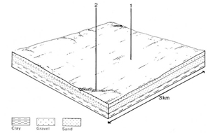
Lower Pleistocene gravels, sands, silts and clays; minor Tertiary alluvium |
| PHYSIOGRAPHY Landscape Elevation range (m) Relative relief (m) Drainage pattern Drainage density (km/km2) |
Almost flat plains, residual Pleistocene terraces 20 - 90 0 - 5 Dendritic <0.1 |
| PRESENT LAND USE |
Uncleared portion: firewood extraction (limited) |
 | 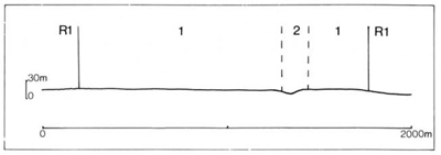 |
| LAND COMPONENT Percentage of land system Diagnostic features | 1 95 Almost flat plains and slightly depressed areas with poorer drainage | 2 5 Incised drainage depressions and bordering slopes |
| PHYSIOGRAPHY Slope %, typical and (range) Slope shape | 1, (0 - 4) Straight | Variable, (0 - 10) Concave |
| SOIL | ||
| Parent material | Clay, silt, sand and gravel, often stratified | Locally derived alluvial lag deposits |
| Description | Very dark greyish brown sandy loam to sandy clay loam topsoil grading into greyish brown similarly textured subsurface soil, often mottled; abrupt change to strongly mottled yellowish brown clay subsoil, commonly alkaline at depth. Varying gravel content | No observations — probably mostly undifferentiated medium textured dark greyish brown topsoil, brown subsoil and appreciable gravel content |
| Classification | Solodic Soils, Solodized Solonetz Soils, Soloths Dy3.23, Dy3.22, Dy3.33, Dy3.21, Dy3.13, Dy3.31, Dy2.43 | - |
| Surface texture | Sandy loam to sandy clay loam | - |
| Surface consistence | Slightly hard to hard when dry | - |
| Depth (m) | >2.0 | - |
| Nutrient status | Low | >2.0 |
| Available soil water capacity | Low to moderate | - |
| Perviousness to water | Slow | - |
| Drainage | Mainly somewhat poor, in places poor | - |
| Exposed stone (%) | 0 | - |
| Sampled profile number | 61, 64, 65 | - |
| NATIVE VEGETATION Structure of vegetation and characteristic species of dominant stratum (+ Predominant species) | Grassy open forest II: Mainly E. tereticornis+ Occasionally E. globoidea or E. melliodora (Heyfield, Seaton areas) predominant or associated Other species sometimes associated include E. bridgesiana, E. polyanthemos | |
|
|
|
|
| ||
|
|
| ||||
— reduction in leaf area, rooting depth and/or perenniality |
resulting in: a) increased deep percolation b) raised winter/spring watertable |
Waterlogging Salting |
1; moderate 1; moderate |
Common: seasonally Common: localised areas |
Removal of trees. Reduced plant-water use in catchment. Reduced plant water use in catchment |
Increased movement of water to groundwater Increased salting in lower areas |
|
|
|
2; low - moderate |
|
|
|
|
With Reduced infiltration |
Waterlogging |
1; low - moderate |
Common; localised areas |
As for structure decline above |
Increased run-on and ponding of water in low-lying areas |
|
|
|
|
|
|
|
| ||||||
© State of Victoria (Agriculture Victoria) 1996 - .

This work, Victorian Resources Online, is licensed under a Creative Commons Attribution 4.0 licence. You are free to re-use the work under that licence, on the condition that you credit the State of Victoria (Agriculture Victoria) as author, indicate if changes were made and comply with the other licence terms.
The licence does not apply to ‘branding’ or some ‘images or photographs’ that may be owned by third parties. We ask you to seek prior approval to use images using the VRO feedback form. Access to higher quality images can also be provided on request.
This page was last updated on .