
Redgum 1 (R1)
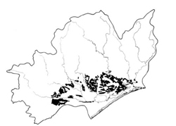 | Area: 857 sq. km (4.2%) Redgum 1 is the most extensive land system in the drier parts of the Eastern lowlands. It occurs on the gently sloping to undulating plains of the earlier Pleistocene terrace and of the more distal parts of the Tertiary flood plain deposits. Dissection is firmly established and integrated drainage has developed, with broad shallow erosional basins holding the main streams. Most of the original land surface has now been removed. Near the southern bank of the Mitchell River flood plain, sink holes have developed where Miocene limestones occur close to the surface. Where sandy rises of Barrier or Perry land systems block the natural drainage, there are poorly drained depressions. Geology and climate are similar to those in Westbury 1 land system but Redgum 1 has lower relief. The very gentle slopes and the well-developed duplex soils are major factors in the general stability of the area. However, the clayey subsoils are commonly sodic and any sheet erosion near the dissected edges of the plain and near the incised drainage ways could be followed by gully erosion. The upper horizons are sometimes thick and sandy due to wind-blown accretions. The soils are similar to those in Redgum 2 land system but appear to lack gilgai micro-relief. Seasonal waterlogging occurs on the flatter slopes. The native vegetation, probably mainly an E. tereticornis grassy open forest II, has mostly been cleared. | 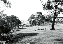 Dissection of the early Pleistocene terraces has often resulted in steep slopes along the drainage channels with gently sloping and undulating terrain adjacent. This dissection distinguishes Redgum 1 from Redgum 2 land system. |
| CLIMATE Rainfall, mean (mm) Temperature, mean (°C) Seasonal growth limitations |
Annual 500 - 800; lowest July or August (30 - 50), highest October (50 - 80) Annual 12 - 14; lowest July (8 - 10), highest February (19 - 21) Temperature <10°C (av.): June - August Rainfall < potential evapotranspiration: November – March |
| GEOLOGY Age, lithology |
Lower Pleistocene terrace and some more distal parts of Tertiary floodplain deposits; gravels, sands, silts and clays; unexposed marine limestone |
| PHYSIOGRAPHY Landscape Elevation range (m) Relative relief (m) Drainage pattern Drainage density (km/km2) |
20 - 160 0 - 20 Dendritic 0.3 |
| PRESENT LAND USE |
Minor proportion uncleared: bush grazing of cattle; timber (minor products and some firewood) |
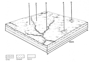 | 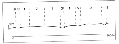 |
| LAND COMPONENT Percentage of land system Diagnostic features | 1 64 Slopes | 2 20 Almost flat areas | 3 10 Drainage depressions | 4 5 Slightly depressed, poorly drained areas on the flats | 5 1 Sink-holes |
| PHYSIOGRAPHY Slope %, typical and (range) Slope shape | 3, (1 - 10) Straight | 1, (0 - 2) Straight | 1, (0 - 5) Concave | <1, (0 - 2) Concave | Variable, (0 - 10) Concave |
| SOIL | |||||
| Parent material | Unconsolidated clay, silt, sand and gravel (often stratified, in places cemented or dense) | Colluvium from components 1 - 3 and/or marine limestone | |||
| Description | Very dark grey to very dark greyish brown loamy sand to sandy loam topsoil, grading into greyish brown in places deep, similarly textured subsurface soil; abrupt change to strongly mottled yellowish brown, blocky clay subsoil. Commonly very gravelly | No observations — probably undifferentiated medium textured gravelly soils | Similar to component 1 and 2, but mottling often extending into topsoil; clay subsoil may have columnar structure | Limited observations — greyish brown to slightly reddish brown clay loam to light clay, mottled to near the surface | |
| Classification | Mostly Solodized Solonetz and Solodic Soils, some Soloths and Yellow Podzolic Soils Dy3.22, Dy5.22, Dy5.21, Dy3.31, Dy3.33, Dy3.23, Db2.31 | - | Soloths, Yellow Podzolic Soils Dy3.41, Db2.41 | Brown Earths Um6.21, Uf6.13 | |
| Surface texture | Loamy sand to sandy loam | - | Sandy loam | Clay loam | |
| Surface consistence | Soft to slightly hard when dry | - | Friable to very firm when moist | Very firm when moist | |
| Depth (m) | >2.0 | >2.0 | >2.0 | >2.0 | |
| Nutrient status | Low to moderately low | - | Low | Moderately low | |
| Available soil water capacity | Low | - | Moderately low | Moderately low | |
| Perviousness to water | Slow | - | Slow | Slow | |
| Drainage | Mostly somewhat poor | - | Very poor to poor | Somewhat poor | |
| Exposed stone (%) | 0 | - | 0 | 0 | |
| Sampled profile number | 68 | - | - | - | - |
| NATIVE VEGETATION Structure of vegetation and characteristic species of dominant stratum (+ Predominant species) | Grassy open forest II: Mainly E. tereticornis+ E. bridgesiana, E. polyanthemos associated On better drained slopes E. bosistoana or E. globoidea occasionally predominant | Mainly open forest I, II, often shrubby: E. tereticornis+ sometimes with E. ovata and occasionally E. cephalocarpa. Understorey often with Melaleuca ericifolia Closed scrub of M ericifolia in poor drained areas | As for components 1, 2 and 3 | ||
|
|
|
|
| ||
|
|
| ||||
— reduction in leaf area, rooting depth and/or perenniality |
resulting in: a) increased deep percolation b) raised winter/spring water table |
Nutrient loss Waterlogging |
Not determined 2; low 3,4,5; moderate |
Not determined Not determined |
Removal of trees Reduced plant-water use in catchment |
Increased movement of water to groundwater; increased base-flow of streams Increased run-on and ponding of water in low-lying areas |
|
|
|
2,5; very low |
|
|
|
|
With Reduced infiltration |
Sheet and rill erosion |
4,5; moderate 1,3,4; low 2,5; very low |
Uncommon: isolated occurrence on cleared land |
As for sheet and rill erosion above |
Increased flash flows |
|
|
|
1; low - moderate 2,4,5; very low |
|
|
|
| ||||||
© State of Victoria (Agriculture Victoria) 1996 - .

This work, Victorian Resources Online, is licensed under a Creative Commons Attribution 4.0 licence. You are free to re-use the work under that licence, on the condition that you credit the State of Victoria (Agriculture Victoria) as author, indicate if changes were made and comply with the other licence terms.
The licence does not apply to ‘branding’ or some ‘images or photographs’ that may be owned by third parties. We ask you to seek prior approval to use images using the VRO feedback form. Access to higher quality images can also be provided on request.
This page was last updated on .