
Nambrok (Nk)
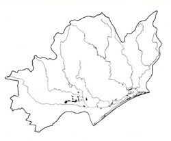 | Area: 32 sq. km (0.2%) Parts of the later Pleistocene terrace which are periodically inundated are mapped in Nambrok land system and occur where drainage is poor and run-off water accumulates, notably to the north of Snake Ridge between Sale and Rosedale. Waterlogging after rainfall has given rise to hydromorphic, locally-saline soils. In recent years irrigation of adjoining land has caused water tables to rise, aggravating the salinity and drainage problems. Artificial drainage installed in many areas, has largely alleviated these problems. The youthful clayey soils have clay loam to silty clay loam topsoils which gradually merge into clays with depth. Subsoils are always mottled, although the depth at which mottling begins and its intensity are not uniform and probably depend on drainage status. The more poorly-drained areas have rusty coloured fine mottles in the topsoils, particularly along root channels. The main soil degradation hazards are increased waterlogging and salinity due to irrigation and clearing of native vegetation higher in the catchment. The salinity hazard is judged to be high. The native vegetation, probably dominated by a grassy open forest II of E. tereticornis, has been almost entirely cleared. | 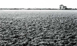 Surface water and pugging of the surface soil by cattle are indicative of the poor drainage of this land system |
| CLIMATE Rainfall, mean (nun) Temperature, mean (°C) Seasonal growth limitations |
Annual 500 - 800; lowest July (30 - 50), highest October (50 - 80) Annual 12 - 14; lowest July (8 - 10), highest February (19 - 21) Temperature <10°C (av.): June - August Rainfall < potential evapotranspiration: November – March |
| GEOLOGY Age, lithology |
Upper Pleistocene alluvial silts and clays |
| PHYSIOGRAPHY Landscape Elevation range (m) Relative relief (m) Drainage pattern Drainage density (km/km2) |
Poorly-drained, alluvial plains and shallow depressions 20 - 40 0 - 1 Dendritic 1.5 |
| PRESENT LAND USE |
|
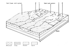 | 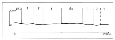 |
| LAND COMPONENT Percentage of land system Diagnostic features | 1 80 Low-lying, poorly drained plains | 2 20 Depressions and channels on poorly drained plains |
| PHYSIOGRAPHY Slope %, typical and (range) Slope shape | <1, (0 - 1) Straight or slightly concave | <1, (0 - 1) Concave |
| SOIL | ||
| Parent material | Alluvial silt and clay | |
| Description | Dark brown to dark greyish brown clay loam or silty clay loam grading into dark yellowish brown, often strongly mottled blocky structured clay subsoil; topsoil mildly acidic, subsoil neutral to alkaline. Low rises with less subsoil mottling | Grey clay loam to silty clay loam with few to many fine yellowish brown mottles, grading into grey and yellowish brown mottled clay subsoil. Surface usually mildly acidic, alkaline at depth |
| Classification | Wiesenboden; some Minimal Prairie Soils on better drained low rises Gn3.93, Gn4.33, Gn4.72 | Humic Gleys Uf6.41, Gn3.43 |
| Surface texture | Clay loam to silty clay loam | Clay loam to silty clay loam |
| Surface consistence | Friable when moist | Friable to firm when moist |
| Depth (m) | >2.0 | |
| Nutrient status | Moderate | |
| Available soil water capacity | Moderate to high | |
| Perviousness to water | Slow | |
| Drainage | Poor to somewhat poor | Very poor to poor |
| Exposed stone (%) | 0 | 0 |
| Sampled profile number | - | 28 |
| NATIVE VEGETATION Structure of vegetation and characteristic species of dominant stratum (+ Predominant species) | Grassy open forest II: E. tereticornis+ Clearing has made it difficult to determine other tree species which may have grown in association | |
|
|
|
|
| ||
|
|
| ||||
- reduction in leaf area, rooting depth and/or perenniality |
resulting in raised saline groundwater table |
|
2; high |
|
|
|
|
With Reduced infiltration |
Waterlogging |
2; moderate – high 1; moderate 2; high |
Common |
As for structure decline above |
Increased ponding of water in lower areas |
| ||||||
© State of Victoria (Agriculture Victoria) 1996 - .

This work, Victorian Resources Online, is licensed under a Creative Commons Attribution 4.0 licence. You are free to re-use the work under that licence, on the condition that you credit the State of Victoria (Agriculture Victoria) as author, indicate if changes were made and comply with the other licence terms.
The licence does not apply to ‘branding’ or some ‘images or photographs’ that may be owned by third parties. We ask you to seek prior approval to use images using the VRO feedback form. Access to higher quality images can also be provided on request.
This page was last updated on .