
McAdam (Mm)
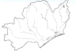 | Area: 9 sq. km (0.1%) McAdam land system occurs on the hard calcareous Devonian marine sediments which are restricted to a small area near Bindi in the north-west of the survey area. The rock here is the Buchan Caves Limestone, a much harder rock formation than the more mixed calcareous sediments of Bindi land system. The terrain is steep and mountainous with a ridge-and-ravine topography and rock outcrops where slopes cut across bedding planes. The mountains occur at low elevations. Somewhat shallow clayey soils have formed on the steep slopes from the hard limestones. Soil reaction varies from slightly acidic to alkaline. Good surface drainage, moderate rainfall and low water-holding capacity allied with drainage fractures and solution channels in the bedrock. promote seasonal deficiencies in available water. The native vegetation. probably a grassy woodland I dominated by E. pauciflora with or without E. viminalis, has been almost entirely removed. | 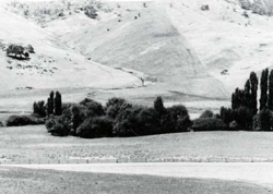 Cleared slopes near Bindi |
| CLIMATE Rainfall, mean (mm) Temperature, mean (°C) Seasonal growth limitations | Annual 500 - 800; lowest July (30 - 50), highest October (50 - 80) Annual 8 - 12; lowest July (3 - 7), highest February (16 - 20) Temperature <10°C (av.): May - September Rainfall < potential evapotranspiration: November – March |
| GEOLOGY Age, lithology | Devonian limestones, mainly Buchan Caves Limestone (Buchan Group) |
| PHYSIOGRAPHY Landscape Elevation range (m) Relative relief (m) Drainage pattern Drainage density (km/km2) | Steep mountains with ridge-and-ravine topography 400 - 800 160 - 320 Dendritic 1.0 |
| PRESENT LAND USE | Mostly cleared: grazing of beef cattle and sheep |
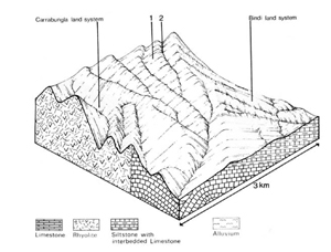 | 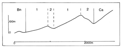 |
| LAND COMPONENT Percentage of land system Diagnostic features | 1 65 Long slopes parallel to rock bedding | 2 35 Short steep rocky slopes cutting across bedding planes |
| PHYSIOGRAPHY Slope %, typical and (range) Slope shape | 20 - 30. (10 - 50) Straight | 30 - 40. (20 - 50) Straight to convex |
| SOIL | ||
| Parent material | Limestone | |
| Description | Dark blocky or crumb structured clay loam to light clay grading into reddish brown or less commonly brown, blocky light or medium clay subsoil. In places very stony or with parent rock floaters; usually shallow. Component 2 has appreciable rock outcrop | |
| Classification | Terra Rossa Soils. Lithosols Uf6.12. Gn4.13 | |
| Surface texture | Clay loam to light clay | |
| Surface consistence | Hard when dry, firm when moist | |
| Depth (m) | <0.8 | |
| Nutrient status | Moderate | |
| Available soil water capacity | Low | |
| Perviousness to water | Moderate | |
| Drainage | Good | |
| Exposed stone (%) | Variable; 20 - 70 | |
| Sampled profile number | - | |
| NATIVE VEGETATION Structure of vegetation and characteristic species of dominant stratum (+ Predominant species) | Grassy woodland I: Upper slopes — E. pauciflora+ Lower slopes — E. pauciflora+, E. viminalis+ | |
Disturbance | Affected process and trend | Primary resultant deterioration | Casual activities | Primary off-site process | ||
Form | Susceptibility of components | Incidence with components | ||||
— reduction in leaf area, rooting depth and/or perenniality |
resulting in increased deep percolation |
|
|
|
|
|
|
|
|
|
|
|
|
|
With reduced infiltration |
Sheet and rill erosion |
2; high (low for Lithosols) 1,2; high Not determined |
Increased trafficking, overgrazing, export of organic matter |
As for sheet and rill erosion above |
Increased flash flows |
|
|
|
|
|
|
|
| ||||||
© State of Victoria (Agriculture Victoria) 1996 - .

This work, Victorian Resources Online, is licensed under a Creative Commons Attribution 4.0 licence. You are free to re-use the work under that licence, on the condition that you credit the State of Victoria (Agriculture Victoria) as author, indicate if changes were made and comply with the other licence terms.
The licence does not apply to ‘branding’ or some ‘images or photographs’ that may be owned by third parties. We ask you to seek prior approval to use images using the VRO feedback form. Access to higher quality images can also be provided on request.
This page was last updated on .