
Maffra 2 (M2)
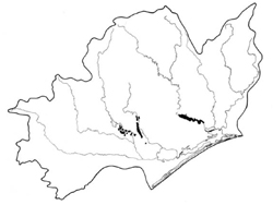 | Area: 78 sq. km (0.4%) The highest parts of the modern flood plains with a less active flood regime and with relatively uniform materials are mapped as Maffra 2 land system. The plains arc almost flat, with few channels or levees, and the alluvium tends to be clayey and relatively pervious. Generally the length of time since deposition of alluvium and the high organic matter production due to high moisture availability and nutrient-rich parent materials have allowed the development of two different soil types; those with good drainage and those with poorly-drained subsoils. Both of these have friable, black to very dark greyish brown topsoils, rich in organic matter. Soil development has been similar to that in Maffra I land system. but the lower frequency of the poorly-drained soils in Maffra 2 may he explained by the better permeability and/or deeper ground water. The soils are generally fertile and have a low erosion hazard, but are susceptible to compaction, particularly when wet. As in Maffra 1, the native vegetation has been almost completely cleared. It was probably also an E. tereticornis grassy open forest II. | 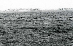 A broad. almost flat flood plain without active or relict channels. typical of Maffra 2 land system. |
| CLIMATE Rainfall, mean (mm) Temperature, mean (°C) Seasonal growth limitations |
Annual 500 - 800: lowest July (30 - 50). highest October (50 - 80) Annual 12 - 14; lowest July (8 - 10), highest February (19 - 21) Temperature <10°C (av.): June - August Rainfall < potential evapotranspiration: November – March |
| GEOLOGY Age, lithology |
Holocene alluvium of clays and silts |
| PHYSIOGRAPHY Landscape Elevation range (m) Relative relief (m) Drainage pattern Drainage density (km/km2) |
Almost flat, partly active alluvial plains 20 - 40 0 - 5 Irregular and braided 1.3 |
| PRESENT LAND USE |
|
 | 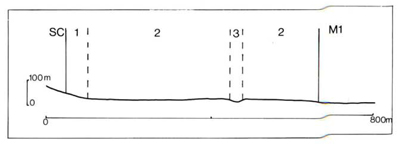 |
| LAND COMPONENT Percentage of land system Diagnostic features | 1 10 Fans and aprons | 2 80 Broad, almost flat flood plains | 3 10 Mainly relict flat bottomed channels |
| PHYSIOGRAPHY Slope %, typical and (range) Slope shape | 4, (3 - 5) Straight to concave | 1, (0 - 2) Straight | <2, (0 - 3) Concave |
| SOIL | |||
| Parent material | Clayey and silty alluvium | ||
| Description | Mostly clayey and silty colluvium from adjacent land systems | Probably mainly black to very dark friable silty loam to clay loam grading into greyish brown to reddish brown clay loam to light clay subsoil | Probably mainly greyish brown topsoil merging into grey. strongly mottled subsoil; textures similar to component 2 |
| Classification | Probably mainly greyish brown loam to clay loam changing abruptly to mottled yellowish brown blocky alkaline clay subsoil | Prairie Soils, some Wiesenboden Um5.52. Uf6.12 | Wiesenboden/Humic Gleys Gn3.53 |
| Surface texture | Solodic Soils, sometimes strongly gleyed Dy3.13, Dy3.23 | Silty loam to clay loam | Fine and medium textures |
| Surface consistence | Loam to clay loam | Friable when moist | Friable to firm when moist |
| Depth (m) | Firm when moist | >2.0 | >2.0 |
| Nutrient status | >2.0 | Moderate to high | |
| Available soil water capacity | Moderate | Moderate to high | |
| Perviousness to water | Moderate | Slow to moderate | |
| Drainage | Slow | Moderately good to good | Very poor to poor |
| Exposed stone (%) | Poor to somewhat poor | 0 | 0 |
| Sampled profile number | 0- | - | - |
| NATIVE VEGETATION Structure of vegetation and characteristic species of dominant stratum (+ Predominant species) | Grassy open forest II: E. tereticornis+ Clearing has made it difficult to determine if any other predominant or associated tree species | ||
Disturbance | Affected process and trend | Primary resultant deterioration | Casual activities | Primary off-site process | ||
Form | Susceptibility of components | Incidence with components | ||||
| Alteration of vegetation: - reduction in leaf area, rooting depth and/or perenniality | Reduced transpiration, resulting in increased deep percolation and leaching | Nutrient loss | Not determined | Not determined | Reduced plant-water use | Increased movement of water to groundwater; increased base-flow of streams |
| Increased exposure of surface soil | Increased overland flow and soil detachment | Sheet and rill erosion | 2,3; very low 1; low | Uncommon; localised occurrences | Cultivating, overgrazing, road and dam building and other earth-moving activities, trafficking by stock and vehicles. | Increased flash flows, sediment load and turbidity of streams. |
| Increased physical pressure on soil | Increased compaction With Reduced infiltration | Structure decline Sheet and rill erosion | 1.3; moderate 2; moderate-high 2,3; very low 1; low | Not determined Not determined | Increased trafficking cultivation, overgrazing, export of organic matter. As for sheet and rill erosion above | - Increased flash flows |
| Increased soil disruption | Increased soil break-up | Gully erosion | 1,3; very low 2; low | Uncommon | As for sheet and rill erosion above | Increased sediment load. |
| Comments: Disturbances on adjacent land systems do contribute to sheet, rill and gully erosion. | ||||||
© State of Victoria (Agriculture Victoria) 1996 - .

This work, Victorian Resources Online, is licensed under a Creative Commons Attribution 4.0 licence. You are free to re-use the work under that licence, on the condition that you credit the State of Victoria (Agriculture Victoria) as author, indicate if changes were made and comply with the other licence terms.
The licence does not apply to ‘branding’ or some ‘images or photographs’ that may be owned by third parties. We ask you to seek prior approval to use images using the VRO feedback form. Access to higher quality images can also be provided on request.
This page was last updated on .