
Kirchubel (Kl)
 | Area: 287 sq. km (1.4%) In the west of the uplands precipitous mountain slopes with a high rainfall and vigorous vegetative growth are mapped in Kirchubel land system. These slopes flank the major plateaux on granodiorite, for example Mount Baw Baw and the Toorongo Plateau, and result from differential erosion, although faulting may be involved in places. A cool climate, high rainfall and a parent rock that weathers relatively easily have produced deep soils, even on steep slopes. Active weathering of iron-bearing minerals, combined with leaching and a high production of organic matter have resulted in well-aggregated soils with a crumb or fine blocky structure in the upper horizons; subsoils are usually apedal with an earthy fabric. The soils are moderately acidic and permeable. Mica and feldspar are often abundant in the deep subsoil and hence soils are relatively fertile despite leaching. Steep slopes are susceptible to sheet erosion once disturbed but vertical slopes, such as road batters, do not slump due to the excellent soil drainage. The well-structured topsoils are sensitive to compaction. The vegetation is mainly layered open forest III or IV, with open forest II on more exposed slopes. | 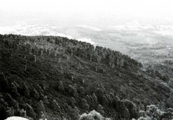 A long, steep slope, typical of Kirchubel land system, on the southern side of Mount Toorongo. A long, steep slope, typical of Kirchubel land system, on the southern side of Mount Toorongo. |
| CLIMATE Rainfall, mean (mm) Temperature, mean (°C) Seasonal growth limitations |
Annual 900 - 1600; lowest January or February (60 - 90), highest August or October (120 - 150) Annual 8 - 12; lowest July (3 - 7), highest February (16 - 20) Temperature <10°C (av.): April - October Rainfall < potential evapotranspiration: February; frequent winter snow |
| GEOLOGY Age, lithology |
Devonian; Baw Baw and Toorongo Granodiorites, Tynong Granite and associated metamorphics |
| PHYSIOGRAPHY Landscape Elevation range (m) Relative relief (m) Drainage pattern Drainage density (km/km2) |
Long, precipitous mountain slopes with very high relief and ridge-and-ravine topography 240 - 1180 200 - 720 Dendritic 0.5 |
| PRESENT LAND USE |
|
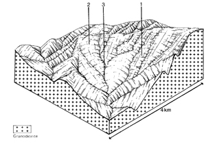 | 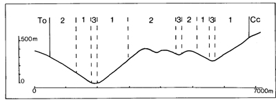 |
| LAND COMPONENT Percentage of land system Diagnostic features | 1 55 Long, very steep sheltered slopes | 2 40 Long, steep, more-exposed slopes | 3 5 Drainage corridors |
| PHYSIOGRAPHY Slope %, typical and (range) Slope shape | 40 - 50, (30 - 70) Straight | 30 - 50, (15 - 70) Straight | -, (0 - 5) Straight |
| SOIL | |||
| Parent material | Granodiorite, granite and associated metamorphic rock | Alluvium | |
| Description | Black sandy loam to sandy clay loam merging into red or brown sandy clay loam to sandy clay; deep; subsoils often fine blocky structured, sometimes apedal | Very dark to black sandy loam to sandy clay loam merging into red or brown sandy clay loam to sandy clay; mainly deep. Maybe somewhat stony; subsoil structure as in component 1 | Limited observations — probably variable; fine to coarse textured, sometimes gravelly |
| Classification | Red and Brown Earths/Krasnozems, Lithosols Gn2.21, Gn2.11, Gn3.11, Gn4.11, Gn4.10, Um5.52, Um6.12, Um7.11 | Red and Brown Earths/Krasnozems, minor Lithosols Gn4.11, Gn4.31, Gn2.11, Um5.51 | Alluvial Soils Uc5.21, Uf1.41 |
| Surface texture | Sandy loam to sandy clay loam | Sandy loam to sandy clay loam | Sandy loam to sandy clay |
| Surface consistence | Soft | Soft | Soft |
| Depth (m) | >2.0 | >1.5 | Variable |
| Nutrient status | Low to moderate | Low to moderate | |
| Available soil water capacity | Moderate | Moderate | |
| Perviousness to water | Rapid | Rapid | |
| Drainage | Good | Often waterlogged | |
| Exposed stone (%) | <10 | 0 | |
| Sampled profile number | - | 35 | - |
| NATIVE VEGETATION Structure of vegetation and characteristic species of dominant stratum (+ Predominant species) | Layered open forest II, IV: E. regnans+ with or without E. obliqua and E. cypellocarpa; E. nitens occasionally predominant. Nothofagus cunninghamii associated in higher rainfall areas | Open forest II, often shrubby: Pure or mixed stands of E. obliqua, E. sieberi, E. cypellocarpa, E. baxteri | Layered open forest III, IV: E. regnans+; E. viminalis+ (at lower elevations) |
Disturbance | Affected process and trend | Primary resultant deterioration | Casual activities | Primary off-site process | ||
Form | Susceptibility of components | Incidence with components | ||||
— reduction in leaf area, rooting depth and/or perenniality
| Reduced transpiration, resulting in: a) increased deep percolation b) increased regolith wetness Decreased root-binding |
Nutrient loss Landslip and soil creep Soil creep | Not determined 1,2; moderate 12; moderate | Not determined Not determined Not determined | Removal of trees Usually after the removal of native vegetation Usually after the removal of native vegetation | Increased movement of water to groundwater; increased base-flow of streams Increased sediment load Increased sediment load |
| Increased overland flow and soil detachment | Sheet and rill erosion | 1,2; high | Not determined | Clearing, logging, burning, road building and other earth-moving activities | Increased flash flows and sediment load. |
| Increased compaction With Reduced infiltration | Structure decline Sheet and rill erosion | 1,2,3; moderate - high 1,2; high | Not determined Not determined | Increased trafficking, export of organic matter As for sheet and rill erosion above | - Increased flash flows |
| Increased soil break-up | Gully erosion | 1,2; high
| Not determined | As for sheet and rill
| Increased sediment load. |
| Comments: Regeneration of vegetative cover is quite rapid because of good growing conditions | ||||||
© State of Victoria (Agriculture Victoria) 1996 - .

This work, Victorian Resources Online, is licensed under a Creative Commons Attribution 4.0 licence. You are free to re-use the work under that licence, on the condition that you credit the State of Victoria (Agriculture Victoria) as author, indicate if changes were made and comply with the other licence terms.
The licence does not apply to ‘branding’ or some ‘images or photographs’ that may be owned by third parties. We ask you to seek prior approval to use images using the VRO feedback form. Access to higher quality images can also be provided on request.
This page was last updated on .