
Gormandale (Gd)
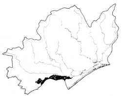 | Area: 296 sq. km (1.5%) This land system is confined to the northern slopes of the Baragwanath Anticline, along the steeper land near the Rosedale Monocline. The hills and slopes mostly occur on very sandy and often lateritised Tertiary materials but localized variation in texture is not uncommon. Although the sands are suitably sized for aeolian transport most of the land forms have formed through erosion by water. Springs and seepage areas occur in the lower tracts of fluvial corridors, the larger of which are mapped in Sandy land system. Under the high rainfall, acidic soils, usually with black and dark brown, cemented layers (coffee-rock) at depth, have developed where the depth of sand is greater than 0.5 m. Sometimes the brown, sandy, subsoil layer is not cemented. Where clay underlies the sand cover at less than about 0.5 m depth, it is common to find acidic duplex soils with yellow, mottled clay subsoils. The soils are droughty and infertile. The vegetation in uncleared areas is mostly ferny or heathy woodland I and II with shrubby woodland I and II in alluviated valley floors. Similar vegetation probably once covered the cleared land. | 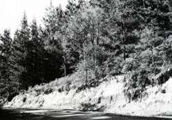 Deep, white sands with coffee rock, now being used for pine growing, are common in Gormandale land system. |
| CLIMATE Rainfall, mean (mm) Temperature, mean (°C) Seasonal growth limitations | Annual 700 - 1200; lowest January (30 - 60), highest October (60 - 90) Annual 12 - 14; lowest July (8 - 10), highest February (19 - 21) Temperature <10°C (av.): May - September Rainfall < potential evapotranspiration: November – March |
| GEOLOGY Age, lithology | Mainly Tertiary sands, often lateritic |
| PHYSIOGRAPHY Landscape Elevation range (m) Relative relief (m) Drainage pattern Drainage density (km/km2) | Hills and slopes on the northern flanks of the Baragwanath Anticline 20 - 320 20 - 60 Dendritic 0.4 |
| PRESENT LAND USE | Approximately half the area uncleared: some areas in Holey Plains State Park; apiculture (limited) Cleared portion: softwood forestry; grazing of beef cattle and sheep on both native and improved pastures |
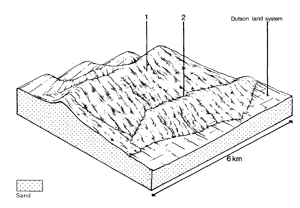 | 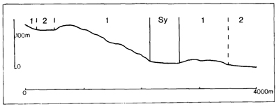 |
| LAND COMPONENT Percentage of land system Diagnostic features | 1 85 Crests, slopes and low hills | 2 15 Valley flats |
| PHYSIOGRAPHY Slope %, typical and (range) Slope shape | 5 - 10, (0 - 15) Variable, predominantly concave or convex | 3, (0 - 5) Straight |
| SOIL | ||
| Parent material | Windblown and colluvial sand over highly variable substrata, usually older weathered clay, gravel or lateritic material | Colluvium and alluvium |
| Description | Mostly deep sand with whitish subsurface and brown or black and brown hardpan (coffee rock) or nodular concretions at depth; lighter coloured sand below. Occasionally shallow dark and grey sand overlies yellow mottled acidic clay subsoil | Limited observations — probably deep sand with black and brown hardpan including coffee rock; deep undifferentiated sand |
| Classification | Podzols, some Yellow Podzolic Soils Uc2.31 and Uc2.36 common; also Uc2.21, Uc2.32, Uc2.34, Uc4.32, Dy5.21 | Podzols, Alluvial Soils Uc2.36, Uc1.2 |
| Surface texture | Sand | - |
| Surface consistence | Soft | - |
| Depth (m) | >2.0 | >2.0 |
| Nutrient status | Low | Low |
| Available soil water capacity | Low | - |
| Perviousness to water | Rapid | - |
| Drainage | Mostly somewhat excessive | Poor to somewhat poor |
| Exposed stone (%) | 0 | 0 |
| Sampled profile number | 70, see also Nicholson (1978) Profile 758 | - |
| NATIVE VEGETATION Structure of vegetation and characteristic species of dominant stratum (+ Predominant species) | Ferny or heathy woodland I, II: Species composition and predominance variable — frequently one or more of E. consideniana, E. nitida and E. viminalis var. racemosa, often with Banksia serrata, E. dives, E. cephalocarpa, E. globoidea and E. muellerana occur less commonly | Limited data — similar to Sandy land system, component 3 |
Disturbance | Affected process and trend | Primary resultant deterioration | Casual activities | Primary off-site process | ||
Form | Susceptibility of components | Incidence with components | ||||
— reduction in leaf area, rooting depth and/or perenniality |
resulting in increased deep percolation and leaching |
|
|
|
|
|
|
Increased wind velocity over soil and increased detachment of sand |
Wind erosion |
1; moderate - high |
Uncommon: limited to cleared areas |
As for sheet and rill erosion above |
Encroachment by sand |
|
With Reduced infiltration |
Sheet and rill erosion |
1; moderate - high |
Uncommon: severe in localised areas |
As for sheet and rill erosion above |
Increased flash flows |
|
Increased loosening of sand |
Wind erosion |
2; moderate 1; moderate - high |
Uncommon: limited to cleared areas |
As for sheet and rill erosion above |
Encroachment by sand |
| ||||||
© State of Victoria (Agriculture Victoria) 1996 - .

This work, Victorian Resources Online, is licensed under a Creative Commons Attribution 4.0 licence. You are free to re-use the work under that licence, on the condition that you credit the State of Victoria (Agriculture Victoria) as author, indicate if changes were made and comply with the other licence terms.
The licence does not apply to ‘branding’ or some ‘images or photographs’ that may be owned by third parties. We ask you to seek prior approval to use images using the VRO feedback form. Access to higher quality images can also be provided on request.
This page was last updated on .