
Elizabeth (Eh)
 | Area: 175 sq. km (0.9%) Elizabeth land system occurs at relatively high elevation but below the subalpine tract, mainly in the northern parts of the East Victorian Uplands and along the major interfluves of the acid volcanics, mainly the Wellington Rhyolites and the Snowy River Volcanics. The terrain is mountainous with ridge-and-ravine topography and long, steep slopes, occasionally leading down to major streams, notably the Wellington River. The land is similar in geology and topography to Carrabungla land system but it is much more humid, particularly in the west. High rainfall in a cool climate and parent rocks that weather relatively easily have produced moderately-deep soils except on very steep slopes. The soils are well-aggregated and have a crumb or granular structure in the upper horizons but may become massive and earthy in the subsoil. They are moderately acidic and permeable. The vegetation is mainly shrubby open forest II or III. On the protected upper slopes, mostly at higher elevations, the forests are often layered and have species indicative of humid conditions. | 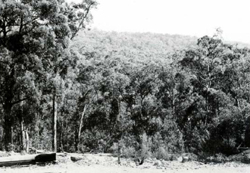 Slopes with shrubby open forest of box and stringybark species typical of component 1. |
| CLIMATE Rainfall, mean (mm) Temperature, mean (°C) Seasonal growth limitations | Annual 800 - 14(X): lowest January or February (50 - 90), highest August or September (120 - 180) Annual 8 - 12; lowest July (3 - 7), highest February (16 - 20) Temperature <10°C (av.): April - October Rainfall < potential evapotranspiration: January. February; occasional winter snow |
| GEOLOGY Age, lithology | Devonian rhyolites and rhyodacites (Wellington Rhyolites and Snowy River Volcanics) |
| PHYSIOGRAPHY Landscape Elevation range (m) Relative relief (m) Drainage pattern Drainage density (km/km2) | Steep mountains with ridge-and-ravine topography 180 - 1520 120 - 540 Dendritic 1.0 |
| PRESENT LAND USE | Uncleared: hardwood forestry (mainly for general construction); apiculture; summer hush grazing of cattle; recreation — bushwalking |
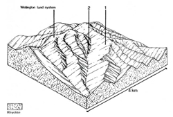 | 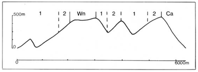 |
| LAND COMPONENT Percentage of land system Diagnostic features | 1 80 Exposed slopes and ridges | 2 20 Protected upper slopes |
| PHYSIOGRAPHY Slope %, typical and (range) Slope shape | 30 - 40. (10 - 60) Straight | 30 - 40, (10 - 60) Straight |
| SOIL | ||
| Parent material | Rhyolite and rhyodacite | Rhyolite and rhyodacite |
| Description | Brown sandy loam to clay loam merging into sometimes stony red or brown sandy clay loam to clay loam | Black sandy loam to clay loam merging into sometimes stony brown sandy clay loam to clay loam |
| Classification | Brown and Red Earths. some Lithosols Um5.52, Gn2.41 | Brown Earths, some Lithosols Um6.21, Um7.11 |
| Surface texture | Sandy loam to clay loam | |
| Surface consistence | Soft to slightly hard | |
| Depth (m) | <1.5 | |
| Nutrient status | Low to moderate | |
| Available soil water capacity | Moderate | |
| Perviousness to water | Rapid | |
| Drainage | Good | |
| Exposed stone (%) | <15 | |
| Sampled profile number | - | - |
| NATIVE VEGETATION Structure of vegetation and characteristic species of dominant stratum (+ Predominant species) | Shrubby open forest II. III: E. obliqua+ or E. sieberi+; E. polyanthemos and E. muellerana often associated | Open forest III (often shrubby or layered): E. delegatensis+, often with E. rubida. Possibly replaced by E. regnans+ and E. obliqua at lower elevations |
Disturbance | Affected process and trend | Primary resultant deterioration | Casual activities | Primary off-site process | ||
Form | Susceptibility of components | Incidence with components | ||||
— reduction in leaf area, rooting depth and/or perenniality — reduction in density of tree roots |
resulting in: a) increased deep percolation b) increased regolith wetness Decreased root-binding |
Nutrient loss Soil creep Soil creep |
Not determined 1,2: high 12; high |
Not determined Not determined Not determined |
Removal of trees Accelerated by clearing of native vegetation Accelerated by clearing of native vegetation |
Increased movement of water to groundwater; increased base-flow of streams Increased sediment load Increased sediment load |
|
|
|
|
|
burning, overgrazing, road building and other earth-moving activities. |
and sediment load. |
|
With Reduced infiltration |
Sheet and rill erosion |
1.2: high |
Not determined |
in topsoil As for sheet and rill erosion above |
Increased flash flows |
|
|
|
|
|
erosion above |
|
| ||||||
© State of Victoria (Agriculture Victoria) 1996 - .

This work, Victorian Resources Online, is licensed under a Creative Commons Attribution 4.0 licence. You are free to re-use the work under that licence, on the condition that you credit the State of Victoria (Agriculture Victoria) as author, indicate if changes were made and comply with the other licence terms.
The licence does not apply to ‘branding’ or some ‘images or photographs’ that may be owned by third parties. We ask you to seek prior approval to use images using the VRO feedback form. Access to higher quality images can also be provided on request.
This page was last updated on .