
Dutson (Dn)
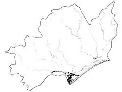 | Area: 120 sq. km (0.6%) In the Seaspray-Dutson area the land has been uplifted from beneath the sea by monoclinal movements associated with the Baragwanath Anticline. Perry, Barrier and Dutson land systems are widespread in this area. Dutson land system consists of almost flat to gently sloping plains with land forms of marine origin and with both sandy and sodic, clayey materials. Drainage is undeveloped and diversion or detention of run-off water behind old, coastal sand forms is common, resulting in many poorly-drained areas. Dutson is similar to Redgum I land system in age and topography but its heavier soils show the effects of marine deposition. Shallow groundwater of low to moderate salinity has been detected in some parts of this land system, resulting in a moderate salinity hazard in such areas. | 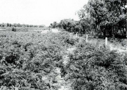 Uneven sandy plains with some woodland still remaining. The bracken is indicative of the sandy. well-drained nature of the soils. |
| The nature of the soils is determined largely by the depth of sand over more clayey substrata. Where the sands are deeper than 0.5 to I m the underlying clayey materials appear to have little or no influence on soil formation processes. These soils, with topsoil darkened by humus merge into paler-coloured sands that overlie soft, bright yellowish-brown, sandy layers or cemented coffee-rock. The accumulation of iron compounds may extend into the top of the clay. Where the clay is close to the surface, duplex soils have developed, with coarse- to medium-textured upper horizons abruptly overlying clays that are sodic and alkaline at depth. Prior to clearing, grassy woodland II was probably the dominant vegetation, with woodland I and sedgeland in small swamps and swales. | ||
| CLIMATE Rainfall, mean (mm) Temperature, mean (°C) Seasonal growth limitations | Annual 500 - 800; lowest January (30 - 50), highest October (40 - 70) Annual 12 - 14; lowest July (9 - 10), highest February (19 - 20) Temperature <10°C (av.): July Rainfall < potential evapotranspiration: November – March |
| GEOLOGY Age, lithology | Pleistocene sands and clays of marine origin |
| PHYSIOGRAPHY Landscape Elevation range (m) Relative relief (m) Drainage pattern Drainage density (km/km2) | Gently sloping plains 20 - 80 0 - 5 Undeveloped 0.2 |
| PRESENT LAND USE | Mostly cleared: grazing of beef cattle and sheep on improved pastures; extensive softwood plantations Minor proportion uncleared: bush grazing of cattle; apiculture |
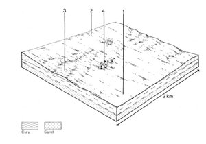 | 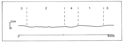 |
| LAND COMPONENT Percentage of land system Diagnostic features | 1 45 Clay plains with thin sand cover | 2 30 Uneven sandy plains | 3 20 Higher sandy rises | 4 5 Swales and swamps |
| PHYSIOGRAPHY Slope %, typical and (range) Slope shape | <2, (0 - 4) Straight | <2, (0 - 4) Straight | 2, (0 - 5) convex | <1, (0 - 2) Straight or concave |
| SOIL | ||||
| Parent material | Sand; marine silt and clay Sand to sandy clay loam abruptly overlying mottled, generally alkaline clay at shallow depth | Sand | Sand | Sand |
| Description | Solodic and Solodized Solonetz | Dark sand over whitish sand overlying bright yellowish brown sand; yellow sand or sometimes clay below | Dark sand over paler sand over coffee rock: yellow sand below | No observations — probably black sand over grey sand over coffee rock or mottled clay |
| Classification | Soils Dy3.42, Dy3.43, Db2.43 and other Dy3. - , Dy5. - and Db2. - soils | Podzols Uc2.21, Uc4.22 and other Uc2. - and Uc4. - soils | Podzols Uc4.3- | Podzols. Humic Gleys - |
| Surface texture | Loamy sand to sandy clay loam | Sand | Sand | |
| Surface consistence | Soft to slightly hard | Loose to soft | Soft | |
| Depth (m) | >2.0 | >2.0 | >2.0 | |
| Nutrient status | Very low to low | Very low | Very low | |
| Available soil water capacity | Moderate | Very low | Very low | |
| Perviousness to water | Slow | Very rapid | Very rapid | |
| Drainage | Poor | Somewhat excessive | Very poor to poor | |
| Exposed stone (%) | 0 | 0 | 0 | |
| Sampled profile number | - | 72 | - | - |
| NATIVE VEGETATION Structure of vegetation and characteristic species of dominant stratum (+ Predominant species) | Sands underlain by clays: | Mainly woodland I, II: Deeper sands: E. viminalis var. racemosa E. bridgesiana, E. cephalocarpa and/or E. ovata; less commonly E. melliodora or E. tereticornis | Sedgeland: Lepidosperma spp. in wetter areas Woodland I: E. ovata around margins | |
Disturbance | Affected process and trend | Primary resultant deterioration | Casual activities | Primary off-site process | ||
Form | Susceptibility of components | Incidence with components | ||||
— reduction in leaf area, rooting depth and/or perenniality |
resulting in: a) increased deep percolation and leaching b) raised winter/spring watertable |
Nutrient loss Waterlogging Salting |
1,4; low 2; moderate - high 3; high 1,2,4; moderate 4; high |
Not determined Common Common |
Removal of trees Reduced water use by plants within the catchment Reduced water use by plants within the catchment |
Increased movement of water to groundwater. Increased waterlogging in lower areas Increased salting in lower areas |
|
Increased wind velocity over soil and increased detachment of sand |
Wind erosion |
12; moderate 3: high 4; low |
Common |
As for sheet and rill erosion above |
Encroachment by sand |
|
With reduced infiltration |
Sheet and rill erosion |
2,3; low 1; low |
Common |
As for sheet and rill erosion above |
Increased waterlogging in lower areas |
|
|
|
3: high 4; low |
|
|
|
| ||||||
© State of Victoria (Agriculture Victoria) 1996 - .

This work, Victorian Resources Online, is licensed under a Creative Commons Attribution 4.0 licence. You are free to re-use the work under that licence, on the condition that you credit the State of Victoria (Agriculture Victoria) as author, indicate if changes were made and comply with the other licence terms.
The licence does not apply to ‘branding’ or some ‘images or photographs’ that may be owned by third parties. We ask you to seek prior approval to use images using the VRO feedback form. Access to higher quality images can also be provided on request.
This page was last updated on .