
Delburn (Dl)
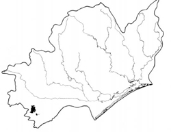 | Area: 46 sq. km (0.2%) In the South Victorian Uplands, erosion has removed most of the Tertiary sediments and associated, weathered products overlying the Older Volcanics. Some areas however, still retain part of the weathered kaolinized, basaltic regolith and these have been mapped in Delburn land system. They occur mainly in the western part of the Morwell River Catchment. Topography consists of hills and long slopes with a broad. dendritic-dissection pattern. The areas of elevated volcanics from which erosion has removed most or all of the kaolinized regolith, are mapped as Neerim and Thorpdale land systems. | 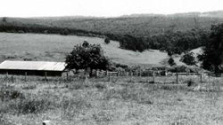 Deep soils mantle the gentle slopes of Delburn land system; grazing is the main land use |
| Basaltic rocks weather to clays and silts and where these are kaolinized much of the original iron content has been removed. Consequently the soils on this kaolinized basalt are predominantly pale brown or yellowish brown and clayey with a medium blocky structure. They contrast with the finely-structured, bright-reddish-brown soils that have developed on the less-weathered basalt in Neerim and Thorpdale land systems. The soils in Delburn are also leached, acidic and generally gradational, though there is a tendency towards a more developed, duplex profile on the gentler slopes of component 2. Most of the native vegetation, probably mainly open forest II with more shrubby understories in valley floors, has been cleared. | ||
| CLIMATE Rainfall, mean (mm) Temperature, mean (°C) Seasonal growth limitations | Annual 700) - 1200; lowest January or February (40 - 70), highest August or October (90 - 120) Annual 12 - 14; lowest July (8 - L0), highest February (19 - 21) Temperature <10°C' (av.): May - September Rainfall < potential evapotranspiration: November – March |
| GEOLOGY Age, lithology | Tertiary basalts (Older Volcanics), highly and deeply weathered |
| PHYSIOGRAPHY Landscape Elevation range (m) Relative relief (m) Drainage pattern Drainage density (km/km2) | Long slopes and hills with a broad dissection pattern 40 - 260 20 - L40 Dendritic 0.9 |
| PRESENT LAND USE | Mostly cleared: softwood forestry: some grazing of beef and dairy cattle on improved pastures Minor proportion uncleared: hardwood forestry (minor timber products with some general construction timber); apiculture |
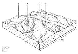 | 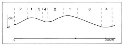 |
| LAND COMPONENT Percentage of land system Diagnostic features | 1 40 Crests and upper slopes | 2 30 Gentle to moderate slopes with pale kaolinitic soil | 3 20 Protected shorter slopes with deeper reddish soils | 4 10 Drainage depressions, often swampy |
| PHYSIOGRAPHY Slope %, typical and (range) Slope shape | 5 - 10, (0 - 20) Convex | 5 - 10. (5 - 30) Straight tending concave | 15, (5 - 30) Straight tending convex | 2, (0 - 5) Concave |
| SOIL | ||||
| Parent material | Weathered, mostly kaolinised basalt | Mainly fine-textured alluvium | ||
| Description | Brown loam to clay loam merging into slightly reddish brown or yellowish brown blocky clay subsoil | Brown sandy clay loam to clay loam merging into pale brown or brownish yellow blocky clay subsoil | Dark greyish brown to dark reddish brown loam to clay loam merging into reddish brown or brown blocky clay subsoil | Limited observations — probably mainly dark silty clay loam over strongly mottled yellowish brown clay subsoil |
| Classification | Xanthozems, Yellow Podzolic Soils Gn3.91, Gn4.31, Gn4.51, Gn4.81, Dy3.41 | Yellow Podzolic Soils. Xanthozems Dy3.11, Dy3.21, Gn3.71 | Krasnozems. Brown Earths Gn3.11. Gn3.52. Gn4.11. Gn4.51 | Probably Wiesenboden, Humic Gleys - |
| Surface texture | Loam to clay loam | Sandy clay loam to clay loam | Loam to clay loam | - |
| Surface consistence | Friable when moist | Friable when moist | Friable when moist | Friable when moist |
| Depth (m) | 1.5 –2.0 | 1.5 - 2.0 | 1.0 - >2.0 | >2.0 |
| Nutrient status | Low to moderate | Low to moderate | Low to moderate | Low to moderate |
| Available soil water capacity | Moderate | Moderate | Moderate | Moderate to high |
| Perviousness to water | Moderate to rapid | Moderate to rapid | Moderate to rapid | Slow to moderate |
| Drainage | Good | Moderately good | Good | Poor |
| Exposed stone (%) | 0 | 0 | 0 | 0 |
| Sampled profile number | - | - | - | - |
| NATIVE VEGETATION Structure of vegetation and characteristic species of dominant stratum (+ Predominant species) | Open forest II: Mixed forests with predominant species and composition variable including E. obliqua (usually predominant), E. cypellocarpa, E. radiata, E. sieberi (mostly on crests) and E. viminalis | Open forest II, III: Mixed forests with predominant species and composition variable — as for components 1 and 2 | Shrubby open forest II: E. ovata+ with or without E. radiata+ | |
Disturbance | Affected process and trend | Primary resultant deterioration | Casual activities | Primary off-site process | ||
Form | Susceptibility of components | Incidence with components | ||||
— reduction in leaf area, rooting depth and/or perenniality |
|
|
| Not determined |
|
|
|
|
|
| Not determined |
|
|
|
With Reduced infiltration |
Sheet and rill erosion |
4: high 1,2,3: moderate | Not determined Not determined |
As for sheet and rill erosion above |
Increased flash flows |
|
|
|
3; low | Not determined |
erosion above |
|
| ||||||
© State of Victoria (Agriculture Victoria) 1996 - .

This work, Victorian Resources Online, is licensed under a Creative Commons Attribution 4.0 licence. You are free to re-use the work under that licence, on the condition that you credit the State of Victoria (Agriculture Victoria) as author, indicate if changes were made and comply with the other licence terms.
The licence does not apply to ‘branding’ or some ‘images or photographs’ that may be owned by third parties. We ask you to seek prior approval to use images using the VRO feedback form. Access to higher quality images can also be provided on request.
This page was last updated on .